Greensboro Bend
Natural Communities
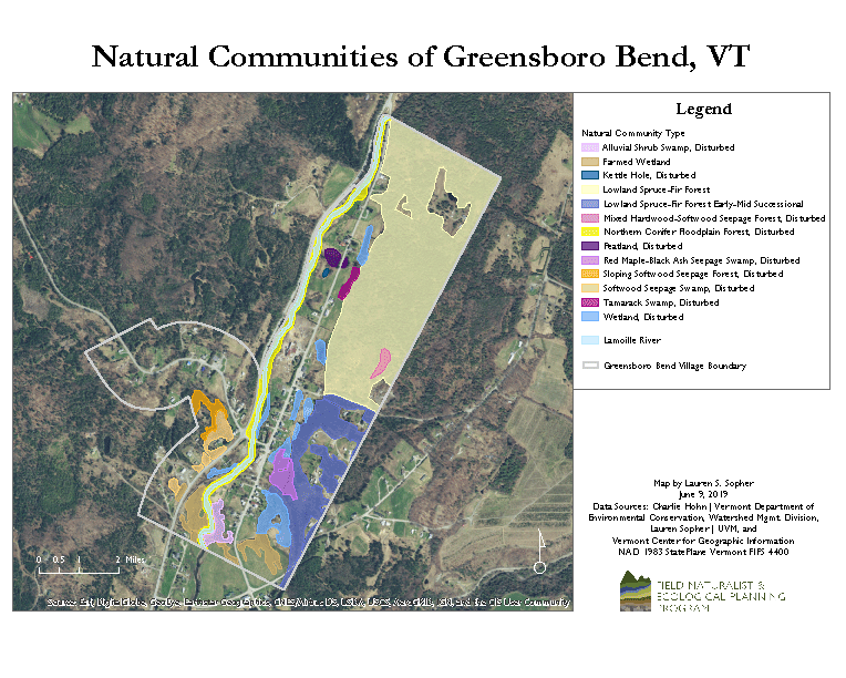
Natural Communities Map
Lauren SopherGreensboro lies within the Northern Vermont Piedmont biophysical region. Biophysical regions share common characteristics of climate, geology, topography, soils, combinations of plants and animals, and human history. The Northern Vermont Piedmont is distinguished by hills and many rivers, a moderate climate—cooler and moister than the Champlain Valley and warmer and drier than the Northern Green Mountains—and rich soils.
A natural community is an interacting assemblage of organisms (plants and animals), their physical environment (bedrock geology, surficial geology, soils, hydrology, and topography), and the natural processes (natural disturbance, human disturbance, and succession) that impact them.
Two forest types, Lowland Spruce-Fir Forest [1] and Northern Conifer Floodplain Forest (or Boreal Floodplain Forest) [2], are highlighted in this document for the following reasons:
- These forests are distinctive upland (Lowland Spruce-Fir Forest) and wetland (Northern Conifer Floodplain Forest) communities in Greensboro Bend.
- These forests are either large in area (Lowland Spruce-Fir Forest) or readily visible to the public via the Lamoille Valley Rail Trail, Vermont Route 16, and Main Street.
- These forests have large restoration potential (Northern Conifer Floodplain Forest). This forest type has an S2 state rank—defined by the Vermont Natural Heritage Inventory as rare in the state, occurring at a small number of sites or occupying a small total area in the state [3].
The scent of a Lowland Spruce-Fir Forest puts evergreen candle fragrances to shame. Terpenes, organic compounds commonly found in conifers, are responsible for the rich olfactory experience we have when walking through this forest type. The Lowland Spruce-Fir forest type dominates the forest block in northeast Greensboro Bend.
The Lowland Spruce-Fir Forest Early-Mid Successional is similar to the Lowland Spruce-Fir Forest, but is dominated by quaking aspen due to past and present logging practices. These patches of forest occur in southeast Greensboro Bend.
The Northern Conifer Floodplain Forest was historically a floodplain, though it is not actively so in some present day areas. Black ash, characterized as a “northern” species, is present in Greensboro Bend; black ash typically replaces green ash in this semi-boreal wetland community. Two other plants characteristic of this forest type, both named after their bird-like features, are the beaked hazelnut, a shrub, and the ostrich fern, an edible herb commonly referred to as “fiddlehead.”
The Alluvial Shrub Swamp is associated with the Northern Conifer Floodplain Forest; it is distinguished by the dominance of the shrub speckled alder.
The Lowland Spruce-Fir Forest is characterized by the following plants and animals:
| Trees | |
|---|---|
Abundant Species
|
Occasional Species
|
| Herbs | |
Abundant Species
|
Occasional Species
|
| Animals | |
Mammals
|
Birds
|
Northern Conifer Floodplain Forest (or Boreal Floodplain Forest)
| Trees | |
|---|---|
Abundant Species
|
Occasional Species
|
| Herbs | |
Abundant Species
|
|
| Animals | |
Mammals
|
Birds
|
Alluvial Shrub Swamp
This community is related to the Northern Conifer Floodplain Forest. It is distinguished by the dominance of shrubs.
| Trees | |
|---|---|
Abundant Species
|
- |
| Shrubs | |
Abundant Species
|
- |
| Herbs | |
Abundant Species
|
- |
| Animals | |
Mammals
|
Birds
|
Footnotes
[1] Lowland Spruce Forest PDF[2] Vermont Natural Communities Types
[3] Synonymy of Vermont Community Types with National Vegetation Classification Associations
Works Consulted
Thompson, E.H., & Sorenson, E.R. (2000). Wetland, Woodland, Wildland: A Guide to the Natural Communities of Vermont. Hanover, NH: University Press of New England.
Sorenson, E.R., Zaino, B., & Hohn, C. (2016). Vermont Natural Community Ranking Specifications. Barre, VT: Vermont Fish and Wildlife Department.