New Haven
Bedrock
Written by Emma Stuhl
Imagine Vermont 540 million years ago. The Green Mountains had not yet risen to define the “Green Mountain State.” In fact, time travelers to this era would find New Haven underwater, and much closer to the equator. There they could lounge, enjoying the shallow, tropical Iapetus Ocean that covered much of modern-day Vermont. They would take in the views of another era, and enjoy the grand vista of the coastal Grenville Mountains, which we can still see parts of today in the Adirondacks. The massive Grenville Mountains stretched from Newfoundland to Mexico and stood higher than today’s Himalayas. One might wish that Vermont were still a tropical destination, and that this sort of mountaineering opportunity still existed in New England. Alas, rocks are always changing, and over the following 540 million years, the landscape transformed in astounding ways.
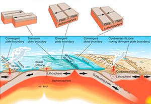
This image shows three types of tectonic plate interactions and some of the resulting geologic formations. Image courtesy of the U.S. Geological Survey.
Click to view larger size
In Vermont, 540 million years ago, separating tectonic plates steadily expanded the land under the sea. As Vermont lay under the Iapetus Ocean, the nearby Grenville Mountains began to erode. Water, wind, and ice cracked and fragmented the solid bedrock into fine particles, which washed and blew downhill. These sediments traveled down streams and into the ocean, where they settled out, along with the shells and dead bodies of small marine creatures. Over the ages, the loose sand and mud cemented into the stone that makes up the modern Green Mountains, and the calcium-rich shells and other bodily remains turned into the limestone and dolostone rocks that underlie much of New Haven. Today, these rocks provide ample calcium, an important plant nutrient, to the soils that cover them and to nearby plant roots.
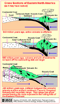
In a dramatic turn of events, the separating plates under the ocean reversed direction and began to creep towards each other. Where the plates met, a ring of volcanoes spewed liquid rock from the depths of the earth. This arc of explosive mountains eventually crashed into the seashore, and lifted the Green Mountains upwards in what is known as the Taconic Orogeny. In the midst of the upheaval, eastern New England, which was then a separate continent, smashed into Vermont. The collision uplifted the mountains even further. This action-packed story, which took place incrementally over 300 million years, explains the formation of most of the bedrock in Vermont.In New Haven, the calcium-rich limestones and dolostones that underlie much of the town were warped in these massive geologic collisions. The extreme heat and pressure of these collisions folded the layers of bedrock and even metamorphosed some of the rocks, changing their physical and chemical structure. A layer of the calcium-rich bedrock recrystallized into marble, which arcs through town in a thin stripe. Some of the bedrock in town started as sand, rather than as the shells of marine organisms; this rock metamorphosed into the quartzite that now lines the eastern edge of town. Over the following millions of years, wind, rain, and ice scoured away the surface of the bedrock that New Haven sits upon, leaving behind the bedrock pattern we see today, a beautiful arc of different rock formations (see map below). In the map below, each color and three-letter code corresponds to a different rock type, which is explained in the legend at the bottom of the page. While there are many types of rock in New Haven, the majority are variants of limestone and dolostone.
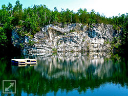
This limestone bedrock was and is an economically important resource. In the 1800 and 1900’s, limestone was mined from the quarry and heated in the kiln on Lime Kiln Road to break it apart into lime for farmer’s fields and for plaster and masonry. The calcium in the bedrock also enriches the surficial materials and the soils that lie above it, slowly fertilizing the landscape.

