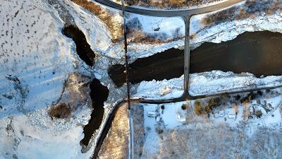
When flooding hit Vermont this past week the state called on UVM’s Unmanned Aircraft Systems (UAS) Team, which is based out of the Rubentein School’s Spatial Analysis Lab. The UAS team used high-tech drone technology to map the damage.
Judy Simpson of WCAX, local Channel 3 News, visited the Rubenstein School Spatial Analysis Lab soon after. She interviewed Director Jarlath O'Neil-Dunne and his team of technicians and students who helped state emergency management officials to track the recent storm and flooding damage throughout Vermont.
“This was a great example of how our team of faculty, staff, and students can use cutting-edge technology and natural resource expertise to help our state respond to disasters," said Jarlath. "Not only are our students learning outside of the classroom, but they are actively engaged in work that directly benefits the citizens of Vermont."
Read the story on WCAX.com: http://www.wcax.com/story/31329449/tracking-vermont-storm-damage-by-drone