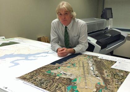
Sam Wear (NRP ’83), assistant chief information officer, has managed New York State’s Westchester County GIS program since the County began to develop geographic information systems (GIS) capacity in the late 1980s. His graduate work in natural resource planning (NRP) in the early 1980s at UVM’s then School of Natural Resources involved the early use of GIS and markedly influenced his professional career direction.
While at UVM, Sam studied with faculty members Robert Manning and Jack Lindsay on his master’s project titled “Allocation and Management of Lakes for Outdoor Recreation: A Case Study for Lake Champlain.” Sam measured the quality and amount of recreation use on Shelburne and Colchester Bays. He surveyed boaters and shoreline landowners, researched land use regulations, and used aerial photography captured over the bays during a series of days and times. Sam analyzed data collected from the photos using GIS, which was at the time, the beginning of the GIS program at UVM, located at 16 Colchester Avenue.
“I’m not sure how many folks realize that UVM’s place in the initial use and contribution to the development of GIS technology in the early 80s was actually very significant,” points out Sam. “UVM was one of ESRI’s earliest installations in the United States. Little did my generation of NRP UVM grad students know they were using some of the very first ESRI (GIS) software products. The GIS tools we were starting to use in the early 80s would ultimately have a dramatic impact on the broad spectrum of natural resources management.”
After graduating from UVM, Sam was headed to the University of Montana to work on his Ph.D. but first detoured to southeastern New York State to visit his future wife, Daryl, also an NRP graduate student, with family in Westchester County. While there, Sam interviewed with the Westchester County Department of Planning, and he never left.
“It’s the only place I’ve ever worked. Thirty-one years later, I’m still in route to Missoula,” he jokes.
Sam manages a core group of seven GIS professional staff, several contractors, and seasonal temporary personnel. Westchester County’s Department of Information Technology GIS program helps County departments and government agencies improve service delivery to County residents by coordinating, designing, and implementing cost-effective geospatial technologies and services. Program activities and resource allocation are aligned with County government priority areas of fiscal responsibility, public health and safety, shared services, and the environment.
“Over the last couple years, here in Westchester County, we’ve seen a steady growth of geospatial activity in the health and human services – government and nonprofit program areas which were very slow to recognize the benefits of and build geospatial capacity,” explains Sam. “It’s been some of my most rewarding government work, as professionals in these areas are so passionate about their work and the populations they serve.”
One of Sam’s most rewarding efforts has been his work with the nonprofit Food Bank for Westchester, which is using GIS technology to better match food collections and deliveries to areas of most need. Similarly, Sam’s department works with the Homeless Services Office in the Westchester County Department of Social Services.
“GIS provides very visual and powerful analytical tools to help better manage the complex geographic network of homeless shelters, service providers, transportation programs, and of course, the underlying individuals and families in the homeless system. Along this line we have done smaller projects with the Red Cross and the Salvation Army.”
From 2004 to 2008, Sam was “loaned out” to the National Geospatial Program at the U.S. Geological Survey headquarters in Reston, Virginia. He commuted via Amtrak and served as a local government liaison to the Geospatial One Stop and early versions of the National Map.
Sam is a GIS devotee. He founded the New York State GIS Association ten years ago because he felt there was a need to start growing the GIS professional field separate from government.
“For too many years, activities and programs within the statewide geospatial community were being dictated by New York State government agencies and personnel. The New York statewide professional GIS community needed a fresh start and new place to grow from. Never in my wildest dreams did I think I would run with GIS as long as I have.”
Sam also started the eSpatially New York blog that he plans to spend more time on when he retires. He hopes it will be a starting place for his consulting work after he leaves civil service.
Sam lives in Westchester County with his wife Daryl. They have two sons, Colin and Lukas, and a younger daughter Hannah who is a sophomore at Providence College. Sam and Daryl enjoy traveling and vacationing in the Adirondacks across the Lake from Burlington. They raised their family on hiking and camping in the Adirondacks, have gone back every year since, and hope to retire there. As a moderately serious runner and golfer, Sam finds golfing to be very therapeutic and great exercise.
“Bob Manning has published several books on benefits and virtues of walking. I know I will have found my place in academic lore when I can get Bob to support and compare the benefits of walking 18-holes of golf to that of similar benefits of walking the Long Trail!”