Look up in the sky, it’s a bird, it's a plane, no it’s a drone! This summer I had the great opportunity to work at UVM’s Spatial Analysis Lab (SAL) as an intern. The SAL uses imagery to create maps to show data. I had the responsibilities of assisting with drone flights and editing map data.
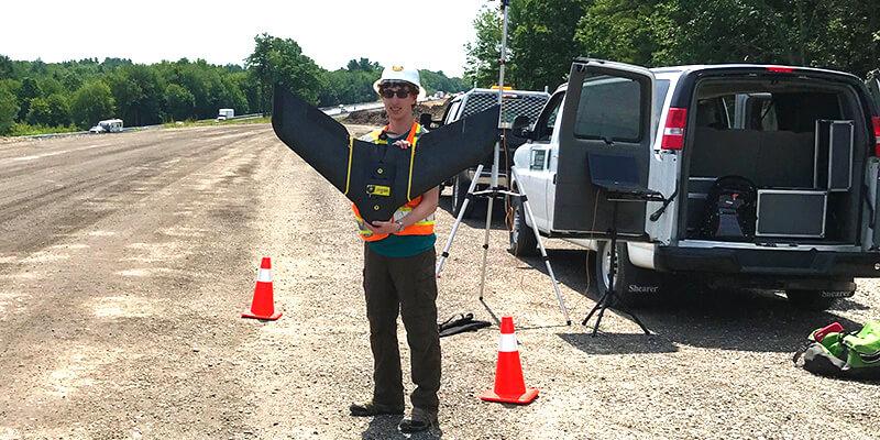
The drones were used to collect high resolution images of the projects to form maps and models. I was usually the visual observer. It was my job to keep the drone within my line of sight and alert the drone operator of potential obstacles and collisions. Projects ranged from marking cracks on a runway to measuring how large a pile of rubble at a construction site was. The drones I had the opportunity to use included quadcopters, a helicopter like drone with 4 propellers and fixed wing drones, which were a wing shaped mini airplanes like the one I am holding in the picture.
I worked on all stages of data gathering and assessment. In addition to learning how to manually fly the quadcopters, I also learned how to program them and the fixed wing drones to fly a set path for data collection on a program called Emotion3. I was taught how to process the data, which is how all the images would be formed into one map on the computer program called Pix4d.
Once the map was made, it had to be checked to make sure all the images connected correctly and make corrections manually where needed. When the images merged incorrectly it left what were called artefacts which looked like television static and blurry marks on the image. Objects could also be contorted, which I saw often as fences bending outwards. These distortions were caused by the different angled photos of the object being connected incorrectly. As the drone flew over an object, it takes images of the object from different positions in the air. The images of the object from different angles allows us to make 3D models and maps of the area of interest. However, the computer sometimes mistakes which part of the object goes where, leading to the errors. This was corrected by manually selecting what images the computer should use for the map in each area.
Once the images were corrected, the data could be added. At this point I would add markings of features such as rail lines, and measure the 3D models to get data such as height and volume. For features, markings were added by digitally drawing features such as lines and shapes around an area on the map and labeling what it was in the ARCmap program. The measurements for volume were done by subtracting a 3D model’s values of an object such as a rubble pile by the flattened version of the model.
In addition to working on drone data sets, I helped with manual edits of larger data sets that had been compiled by a computer. Since computer programs are not perfect at identifying all things in an image, I learned to change what the computer misclassified. An example of this is relabeling a driveway from what the computer thought was bare dirt to pavement. Once this was done the data could be reprocessed and sent back to the client.
Besides assisting with flights and editing data, during the fourth week of the internship we ran a camp for 13 through 17 year olds. I helped teach the campers how to operate the quadcopter drones and assisted them in creating their online maps from the data they collected.
In addition to drone and data related skills, I learned the following helpful tips for future internships. Treat the internship like a job because if you want to get the most experience you will want to prove you can maturely handle tasks and responsibilities like the rest of the employees. Be prepared for most of your time to be the less glamourous work and remember its often the most necessary. Most of the time I was working on data editing and analysis, which was less exciting then drone flights. However, without data analysis the SAL would not be hired to fly the drones in the first place. I found it helpful to take notes, so I had a way of remembering important procedures and helpful suggestions. Record what you did to fix a problem so if anyone else has the same problem they could see how you fixed it. Most importantly, learn to troubleshoot and adapt. I learned on numerous occasions that the tools you work with will at some point do something unexpected. Through my work at the SAL I learned skills and practices that will continue to help me through my career.