
Details and Metadata
Printer-friendly version View XML version Download Ecological Metadata Language file
Methods
The methods followed in the creation of the dataset, including description of field, laboratory and processing steps, and quality control procedures
Current Methods
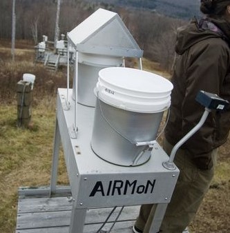
Precipitation sampling
Started: 1993-01-01Year-round daily wet-only precipitation sampling includes: amount, field pH and conductivity, lab pH and conductivity, Ca, K, Mg, Na, NO3, Cl, SO4 and PO4.
Quality Control Measures: Periodic site maintenance and bi-annual calibration, annual site certification, documented QA/QC protocol for field procedures and lab analyses.
Dataset Fields
Detailed documentation of the fields comprising the dataset, including the type of measurement, units where applicable, and any controlled vocabularies or code lists present in the data
Field Name Caption Description Additional Information Ca Ca Ca Concentration
Ratio Units: Cl Cl Cl Concentration
Ratio Units: Date Date Date on which sample bucket was installed on the collector
DateTime Date/Time Format: Field_pH Field_pH pH of the sample as measured in the field laboratory, reported as the negative log of hydrogen ion c
Ratio Units: K K Concentration of potassium
Ratio Units: Lab_pH Lab_pH Negative log of the hydrogen ion concentration as measured at the lab, in pH units
Ratio Units: Mg Mg Concentration of Magnesium (Mg)
Ratio Units: mmSvol_ml mmSvol_ml Volume of sample captured in the sample bucket
Ratio Units: Na Na Sodium concentration. The lower limit of detection is 0.003 mg/L
Ratio Units: NH4 NH4 Ammonium concentration. The lower limit of detection is 0.03 mg/L
Ratio Units: NO3 NO3 Nitrate concentration. The lower limit of detection is 0.03 mg/L
Ratio Units: Site Site Alphanumeric site identification code used by National Program; first two characters are state abbre
Nominal SO4 SO4 Sulfate concentration. The lower limit of detection is 0.02 mg/L
Ratio Units: SubPpt SubPpt Precipitation amount as measured by the NWS rain gage. Trace amounts are indicated by -7.77.
Ratio Units: Sampling Equipment
Equipment and software used to collect data, including how that equipment was used.
No sampling equipment recorded for this dataset
Site Characteristics
The spatial extent of the dataset site coverage, and descriptions of the spatial extent and context for the data collection
- Site Description
West slope of Mt. Mansfield, in the field station at the Proctor Maple Research Center, at 400 m (1300 feet).
Minimum Altitude: 0 meters
Maximum Altitude: 400 meters