Details and Metadata
Printer-friendly version View XML version Download Ecological Metadata Language file
Methods
The methods followed in the creation of the dataset, including description of field, laboratory and processing steps, and quality control procedures
Current Methods
Meteorological variables
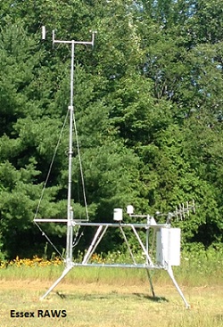
Started: 1999-05-01Meteorological data comes from five remote automated weather stations operated by VT FPR as part of a national network of stations used to predict fire danger. Variables measured are solar radiation, wind speed, wind direction, air temperature, relative humidity, barometric pressure and precipitation. Some stations measure fuel temperature also. The data here are daily averages made available by MesoWest. For detailed information on each station visit MesoWest Weather Summary for Vermont
Instrumentation: Pyranometer, anemometer, temperature probes, Relative humidity sensor, barometric pressure sensor, tipping bucket.
Quality Control Measures: VT FPR maintains the equipment and Mesowest aggregates and QA/QC checks the data published on its website
Dataset Fields
Detailed documentation of the fields comprising the dataset, including the type of measurement, units where applicable, and any controlled vocabularies or code lists present in the data
Field Name Caption Description Additional Information AirTempAveDegC Average Air Temperature Daily average air temperature
Ratio Units: Degrees centigrade
Precision: 0.1AirTempMax Maximum Air Temperature Daily maximum air temperature
Ratio Units: Degrees centigrade
Precision: 0.1AirTempMin Minimum Air Temperature Daily minimum air temperature
Ratio Units: Degrees centigrade
Precision: 0.1BaroPresAvembar Average Barometric Pressure Daily average barometric pressure
Ratio Units: millibars
Precision: 0.01Date Date Date data was collected
DateTime Date/Time Format: M/D/YYYY DayOfRun Day Of Run Data record number
Nominal DayOfYear Day Of Year Day of year from 1 to 365
Interval Units: Day
Precision: 1FuelTempAveDegC Average fuel temperature Daily average temperature of fuel
Ratio Units: Degrees centigrade
Precision: 0.1FuelTempMaxDegC Maximum Fuel Temperature Daily maximum fuel temperature
Ratio Units: Degrees centigrade
Precision: 0.1FuelTempMinDegC Minimum Fuel Temperature Daily minimum fuel temperature
Ratio Units: Degrees centigrade
Precision: 0.1GrowingDegreeDaysBase40 GrowingDegreeDaysBase40 GrowingDegreeDaysBase50 GrowingDegreeDaysBase50 HeatingDegreeDays HeatingDegreeDays PrecipTotalmm Total Precipitation Daily total precipitation (mm)
Ratio Units: millimeters
Precision: 0.01RelativeHumidityAvePercent Average Relative Humidity Daily average relative humidity
Ratio Units: percent
Precision: 1RelativeHumidityMaxPercent Maximum Relative Humidity Daily maximum relative humidity
Ratio Units: percent
Precision: 1RelativeHumidityMinPercent Minimum Relative Humidity Daily minimum relative humidity
Ratio
Unit: percent
Precision: 1SoilTempAveDegC Average Soil Temperature Daily average soil temperature
Ratio Units: Degrees centigrade
Precision: 1SoilTempMaxDegC Maximum Soil Temperature Daily maximum soil temperature
Ratio Units: Dgrees centigrade
Precision: 0.1SoilTempMinDegC Minimum Soil Temperature Daily minimum soil temperature
Ratio Units: Degrees centigrade
Precision: 0.1SolarRadiationTotal_KW-hr-per-m2 Total Solar Radiation Daily Total Solar Radiation
Ratio Units: Kilowatt hour per meter squared (KW-hr-per-m2)
Precision: 0.001WindDirVector Wind Direction Vector Daily wind direction vector
Interval Units: degrees
Precision: 1WindSpeedAveMeterPerSecond Average Wind Speed Daily average wind speed
Ratio Units: meters per second
Precision: 0.01WindSpeedGust Wind Speed Gust Daily highest wind speed gust
Ratio Units: meters per second
Precision: 0.01Year Year Year data was collected
DateTime Date/Time Format: YYYY Sampling Equipment
Equipment and software used to collect data, including how that equipment was used.
No sampling equipment recorded for this dataset
Site Characteristics
The spatial extent of the dataset site coverage, and descriptions of the spatial extent and context for the data collection
- Site Description
Sweezy (Danby VT) Mobile Fire Weather Station (DBYVT1)
Minimum Altitude: 204 meter
Maximum Altitude: 204 meter