Current Maple Research Projects
Other Hosted Projects
Forest Health Monitoring Program
The Forest Health Monitoring Program (FHM) was established in 1991 as a joint effort between the Vermont Department of Forests, Parks and Recreation (FPR) and the Forest Ecosystem Monitoring Cooperative (FEMC) to monitor the condition of a range of tree species in Vermont. After successfully establishing and conducting annual assessments on FHM plots in Vermont for almost three decades, the FEMC has expanded to surrounding states to yield a more complete picture of forest health across the New England and New York region (196 total plots). One of these long-term forest monitoring plots is located at PMRC. Annually, the FHM program visits each plot to collect data on forest stand composition and structure, canopy condition and crown health, tree regeneration, and forest stressors and threats using a variety of field collection tools and protocols.
Funding Source: U.S. Forest Service, with support from the University of Vermont and Vermont Department of Forests, Parks, and Recreation.
Contact: UVM Forest Ecosystem Monitoring Cooperative, femc@uvm.edu

Forest Canopy Tower Meteorological Monitoring
The Forest canopy tower is one of 3 meteorological stations FEMC manages on Mount Mansfield. Meteorological data is collected at 4 heights along the tower from the forest floor to the canopy. The following are collected at all four levels: wind speed and direction, leaf wetness, temperature and relative humidity, while measurements of solar radiation and irradiance are taken at the canopy level.
Funding Source: U.S. Forest Service, with support from the University of Vermont and Vermont Department of Forests, Parks, and Recreation.
Contact: UVM Forest Ecosystem Monitoring Cooperative, femc@uvm.edu
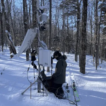
Summit-to-Shore Snow Monitoring Network
UVM’s Water Resources Institute and Department of Civil and Environmental Engineering partnered to install athe Summit-to-Shore Snow Monitoring Network of 22 monitoring stations in a transect through central Vermont, from the shore of Lake Champlain, up and over Mount Mansfield, and ending in Danville. This includes a site at PMRC, which has hosted the station since 2022. The stations monitor snow depth and associated meteorological variables, such as temperature, humidity, radiation components, wind speed and direction, and in some cases precipitation. These data are recorded in order to capture the role of elevation, aspect, variable forest canopy, and short-term and longer-term changes in weather patterns on snowpack accumulation and melt. We hope to measure long records of snow at multiple locations that help understand the nature of changes occurring primarily in the winter. This can influence forest ecology, flood risk, and land/atmosphere feedbacks.
Funding Source: Cold Regions Research and Engineering Laboratory (CRREL)
Contact: Arne Bomblies and Beverley Wemple
Vermont Mesonet
Vermont Mesonet is a statewide network of weather stations built to fill important data gaps and help communities better prepare for extreme weather and support agricultural monitoring and research. By using existing infrastructure and adding new stations in key high-elevation areas, like the western slopes of Mt. Mansfield at the Proctor Maple Research Center, the project gathers real-time weather information from across the state.
That data makes a difference. It helps forecasters improve predictions, supports emergency responders during floods and severe storms, and gives farmers and researchers valuable insight into temperature, wind, snowmelt, and rainfall. These measurements not only protect public safety but also help maple producers understand conditions that influence sap flow and yields.
A secondary station is currently in place at Proctor Maple Research Center, and there are plans to develop a primary station on the property in the coming years.
Funding Source: Leahy Institute for Rural Partnerships, Cold Regions Research and Engineering Laboratory (CRREL). Related regional integrations are funded by the Environmental Protection Agency (EPA) to integrate the monitoring infrastructure into a regional mountain observatory network.
Contact: UVM Water Resources Institute, Joshua Beneš

National Atmospheric Deposition Program
The National Atmospheric Deposition Program (NADP) is a cooperative research program that has monitored atmospheric data across North America since 1978. Operated by the Wisconsin State Laboratory of Hygiene at the University of Wisconsin-Madison, NADP maintains over 250 collection sites to provide long-term environmental data on the effects of air pollution on ecosystems and human health. The program is comprised of several networks that examine trends in concentrations of sulfur, nitrogen, mercury, ammonia, and per- and polyfluoroalkyl substances (PFAS, starting in Spring 2026) and how these pollutants are removed from the atmosphere through precipitation (wet deposition) and settling to the surface (dry deposition). The program brings together federal, state, tribal, and local governmental agencies, educational institutions, private companies, and non-governmental organizations to advance our understanding of how atmospheric processes impact air quality, water resources, and ecosystem health. This collaborative effort generates critical information for environmental management and policy decisions. The University of Vermont's Forest Ecosystem Monitoring Cooperative sponsors the Underhill site (VT99) in Vermont, which contributes to both NADP's Mercury Deposition Network (MDN) and National Trends Network (NTN) monitoring efforts.
Funding Source: U.S. Geological Survey, Vermont Department of Environmental Conservation
General Contact: NADP Coordinator and Principal Investigator, Sarah Benish – sebenish@wisc.edu
Local Contact: UVM Forest Ecosystem Monitoring Cooperative, femc@uvm.edu

USDA UV-B Monitoring and Research Program
The USDA UV-B Monitoring and Research Program (UVMRP) is the only US network providing nationwide surface monitoring of ultraviolet-B (UV-B) irradiance, an atmospheric radiation band of significant concern to USDA due to its known negative impacts on forests, rangelands, and crops. The appearance of an “ozone hole” over the Arctic in March 1990 spurred and sustains (reappearing in March 1997, March 2005, March 2011, March 2020) the USDA interest in documenting the baseline, variability and trending of UV-B across the Nation. Of note is that the National Weather Service’s nationwide network does not monitor UV-B irradiance. UVMRP's mission is "measuring ultraviolet radiation and studying its effects on agriculture, human health, and climate."
Funding Source: USDA – NIFA for Colorado State University
General Contact: Dr. Wei Gao – wei.gao@colostate.edu
Instrumentation Network Contact: George Janson – george.janson@colostate.edu
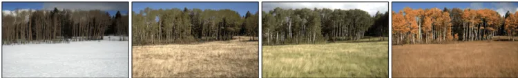
PhenoCam
The PhenoCam Network uses repeat digital photograph to track the rhythmic seasonality of vegetation activity in ecosystems across North America and around the world. This study of this seasonality is the science of phenology, and a phenocam is a digital camera specifically used to study phenology. From Alaska to Arizona, and from Hawaii to Maine, phenocams upload images to our server at NAU every 30 minutes, from sunrise to sunset, 365 days a year. Images and data products characterizing vegetation “greenness” are made publicly available in near-real time through the PhenoCam web page. The PhenoCam archive includes over 80 million images from almost 1000 different cameras. With a total of more than 6000 site-years of derived phenological data, and 75 cameras that have been in continuous operation for over a decade, the PhenoCam Network archive is the largest repository of phenologically-relevant repeat digital photography in the world. In addition to scientific research (over 400 papers have been published using PhenoCam Network data and imagery), PhenoCam provides unique opportunities for education and outreach. Engage in virtual travel through time and space by browsing the PhenoCam image archive!
Contact: Andrew D. Richardson – andrew.richardson@nau.edu
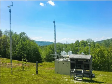
Air Quality Monitoring
The Vermont Department of Environmental Conservation's Air Quality and Climate Division (AQCD) operates a permanent air monitoring site at PMRC. This site is part of the National Air Toxics Trends Stations (NATTS) Network which consists of 27 sites across the country, aimed at collecting long term Hazardous Air Pollutant (HAP) data. It is one of the few rural sites participating in the program. It is also part of the national Interagency Monitoring of Protected Visual Environments (IMPROVE) Program, aimed at measuring and preserving visibility in federal Class I areas.
Funding Sources: Federal NATTS and PM2.5 grants
Contact: David Ruby – david.ruby@vermont.gov