Broad-Scale Forest Disturbance
Aerial Detection Surveys of Forest Disturbance
Damage to trees caused by insects, disease, animals, and weather, are a natural and common occurrence in the region’s forests. Such disturbances can result in changes to biodiversity and species composition, and allow for cycling of nutrients from trees to soil, but can also negatively affect timber quality and other important ecosystem services. There is also concern that climate change and further introduction of non-native pests and pathogens may alter disturbance patterns.
The Data
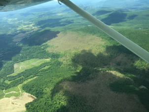
Aerial detection surveys (ADS) have been used to map the cause and extent of forest disturbances in the US for many years.
Annual sketch-mapping surveys are collected by state agencies, and by the US Forest Service on federal lands, via fixed-wing airplane by trained technicians. The US Forest Service Forest Health Monitoring Program set survey methods and standards. Resulting mapped polygons include information on the disturbance cause, type, size, and severity, and are confirmed with ground assessments. Causal agents of disturbance can range from insects and disease, to weather events, wild animals, and humans.
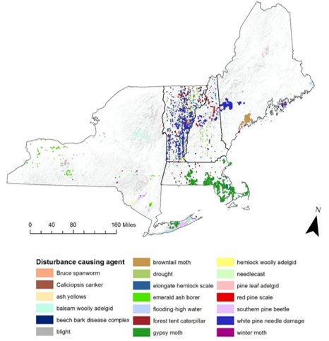
Surveys are a cost-effective and vital tool for detecting emerging forest health issues and tracking trends. However, surveys are not comprehensive of all forest damage and cannot capture subtle disturbance or light decline. Here for the first time we examine forest disturbances via ADS for the northeastern temperate forest region (Massachusetts, Maine, New Hampshire, New York, and Vermont). Please note that survey scope and coverage are not uniform between the five states; therefore, it can appear that some states have more disturbances than others which is a result of differing priorities during surveys.
in Summary
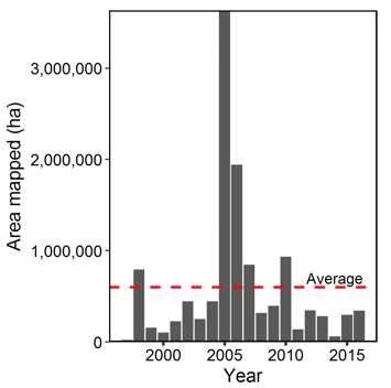
In 2016, 333,640 hectares (824,441 acres) of forest disturbance were mapped in the Northern Forest region. This amounts to less than 2% of the region’s forestland (Figure 7). This is a slight increase from 2015 when 297,051 ha were mapped, and below the average disturbance rate of 3% of the region’s forestland per year (599,015 ha/year) between 1997 and 2016.
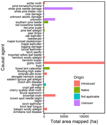
Substantial damage was caused by two introduced (non-native) insects, gypsy moth (Lymantria dispar; 150,510 ha) and browntail moth (Euproctis chrysorrhoea; 28,329 ha) (Figure 8). While both insects have caused disturbance every year in the region between 1997 and 2016, in 2016, we saw the largest amount of disturbance attributed to these insects in the record. In fact, in 2016 introduced insects and diseases caused nearly 7 times more disturbance (198,145 ha) compared to those of native origin (28,607 ha, Figure 8). White pine needle damage was much more widespread (Figure 7) and severe than in previous years (71,364 ha mapped) (Figure 8). Understanding the cause of this damage is ongoing. For more information, see the document from UMass Extension (2016).
Long Term Trends
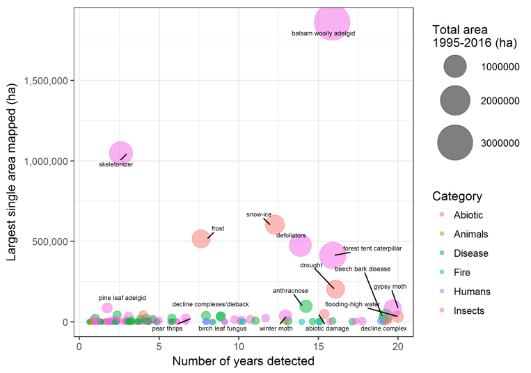
Summing all disturbances per year (1997-2016) reveals substantial year to year variability (Figure 9). This is partially to do with divergent forest health priorities and differing amount of forested land surveyed between the five states. But also, several disturbances are episodic, particularly abiotic weather events (e.g., late spring frost events, drought) and many insect outbreaks. The year of the highest disturbance area occurred in 2005 during an outbreak of the non-native insect, balsam wooly adelgid (1,860,334 ha affected in 2005; Adelges piceae). Only two agents have been detected regionally every year in the 20-year period: gypsy moth and flooding/high water damage (Figure 10).
In total, 194 different damage agents have been mapped in the region since 1997. When the maximum extent of damage caused by specific damage agents is compared to number of years they were mapped, agents have varying impacts in the landscape (Figure 10). In general, insects and abiotic agents have had the largest effect on the region’s forests. The most damaging agents overall have been insects: balsam wooly adelgid (3,147,304 ha), forest tent caterpillar (1,521,682 ha; Malacosoma disstria), and skeletonizer (1,107,655 ha; species unknown).
Abiotic disturbance agents, like ice and frost events and drought, can indiscriminately affect trees regardless of species (although there can be reasons why specific species may be more harmed in abiotic events, due to branching structure, wood density, or habitat, for example) and as a result can cause widespread disturbance. Most other disturbance agents have only affected a small area of regional forestland. Only twelve agents out of 194 have resulted in total damage greater than 100,000 ha in the 20-year period. Many tree diseases identified in the region have not caused large disturbance extents despite frequent occurrence (Figure 10). Of diseases, beech bark disease (a complex between Cryptococcus fagisuga scale and Neonectria fungi (N. faginata and N. ditissima)) and anthracnose (Gnomonia spp.) have resulted in the largest disturbance area. Forest fire is an infrequent event regionally, and when it does occur, the extent is small.
The large effect of introduced insects and diseases over the 20-year period is cause for concern: introduced agents affected two times the amount of forest (4,452,361 ha) compared to those of native origin (2,100,723 ha). However, as new pests and pathogens emerge, often the origins of agents are unknown; agents of unknown origin have caused substantial disturbance overall (3,810,792 ha). These results demonstrate the destructive nature of introduced pests and support the need for continued monitoring of emergent pests.
Regional Context & Implications
ADS data provides the longest region-wide annual record of forest disturbances. Over the past 20 years, relatively low levels of total forest disturbance have been mapped. Most disturbances cause small damage extents and minor total damage.
In total, 194 different causes of disturbance have been mapped, which reflects the varied nature of the region’s forests. Causal agents that lead to repeat and extensive damage are more likely to have significant impacts on forest health. Many biotic agents tend to be chronic or episodic, while abiotic events are often less predictable, yet can result in large disturbed areas. As our climate continues to change, it is projected that extreme weather events will become more frequent, which may mean more storms, wind, ice, frost, or flood events. Elevated summer temperatures, along with changes to rainfall patterns, could lead to more severe and frequent droughts. See the Climate Change Indictors Dashboard (Vermont ANR 2017) for more information. Such abiotic events can cause large areas of damage to multiple tree species (Figure 10). Continued monitoring of disturbances over time is needed to understand the patterns of various types of events and how they may be changing.
Many invasive insects and diseases have been detected in the region, or have been detected nearby. These pests and pathogens have caused much more disturbance to the region’s forests than those of native origin, and we could see widespread declines of specific species, such as ash (Fraxinus spp.) with the spread of emerald ash borer. The good news is that we are not seeing increases in total disturbance over time. The high species diversity in many forest stands and continued vigilant monitoring may be helping to mitigate widespread issues and to identify problems before they become widespread.
- 2016 regional forest disturbance was less than the long-term record
- Non-native insects caused substantial damage region-wide
- Continued monitoring is essential to examine trends and detect novel agents
- 2016 regional forest disturbance was less than the long-term record
- Non-native insects caused substantial damage region-wide
- Continued monitoring is essential to examine trends and detect novel agents
Additional Resources
- UMass Extension, Plant Diagnosis Laboratory. 2016. Dramatic needle browning and canopy dieback of eastern white pine (Pinus strobus) in southern New England. Available online at https://ag.umass.edu/sites/ag.umass.edu/files/content-files/alerts-messages/2016_white_pine_update.pdf
- Vermont Agency of Natural Resources. 2017. Climate Change in Vermont. Available online at: http://climatechange.vermont.gov/vermonts-changing-climate.
FEMC Project Database Link
- Northeastern Regional Aerial Detection Surveys: https://www.uvm.edu/femc/data/archive/project/northeastern_ads
- New York Aerial Forest Health Surveys: https://www.uvm.edu/femc/data/archive/project/nydec-aerial-survey
- Vermont Aerial Sketchmapping: https://www.uvm.edu/femc/data/archive/project/statewide-aerial-sketchmapping-tree-defoliation-mortality