Post-Meeting Content
VMC has made available as much content from the meeting as possible. You can
- - Watch videos of the invited speakers at the plenary session
- - Read abstracts, download talks and watch video of the afternoon contributed presentations, and
- - View the posters presented at our poster session
In addition, VMC will again be publishing a proceedings for the conference, so check back in early 2016.
Plenary Session: 25 Years of Forest Ecosystem Monitoring: Trends, Patterns and Lessons Learned
Long-term trends in forested ecosystems
Moderated by Steve Sinclair, Director of Forests for the Vermont Department of Forests, Parks and Recreation
Back to Top
Contributed Presentations: Forest ecosystem science and monitoring, resource management, and public policy.
Presentations on the new and ongoing research, monitoring, conservation and outreach initiatives from around the region.
| Changing Forests and Management Moderator: Nicole Rogers |
Water Quality and Watersheds Moderator: Tami Wuestenberg |
Fauna and Landscapes Moderator: Cathleen Balantic |
|---|---|---|
Management for old-growth characteristics and late-successional biodiversity in temperate montane forests William Keeton ABSTRACT VIDEO PRESENTATION | Mountain hydrology – 15 years of streamgaging on Mount Mansfield Jamie Shanley ABSTRACT VIDEO PRESENTATION | Decline of bumblebee species diversity in Vermont, 1900-2013 Leif L. Richardson ABSTRACT VIDEO |
Management for old-growth characteristics and late-successional biodiversity in temperate montane forests Presenter: William Keeton, University of Vermont Rubenstein School of Environment and Natural Resources Many have wondered if active management could be used to restore some characteristics of High Conservation Values forests, such as increasingly rare temperate old-growth systems, to managed landscapes. Silvicultural systems for this purpose are being tested in several regions globally and have been the focus of the Vermont Forest Ecosystem Management Demonstration Project (FEMDP), now in its 15th year. The FEMD is testing the hypothesis that an approach called "Structural Complexity Enhancement" (SCE) can accelerate rates of late-successional/old-growth development faster than conventional selection systems. The study employs a Before-After-Control-Impact experimental design to compare SCE against modified single-tree and group selection treatments. Manipulations and controls were applied to 2 ha experimental units and replicated four times at two research areas in Vermont. Field data were collected over two years pre- and 13 years post-treatment. Operational expenses and revenue were tracked as was information on market conditions.
Ten years after harvest, measured aboveground carbon in SCE units was 15.9% less than simulated no-harvest baselines, compared to 44.9% less in conventional treatments. Statistical results show that herbaceous understory composition was strongly affected by overstory treatment and less influenced by soil chemistry and drought stress. However, diversity for sensitive, late-successional herbaceous plants increased significantly in SCE units and decreased significantly in the semi-open conditions within group selection units. Fungi and salamander responses were strongly associated with microsite characteristics, particularly coarse woody debris, and increased significantly under SCE, but showed no statistically significant decrease in gaps created by group selection. SCE is economically viable under the right site and market conditions, but does not maximize timber revenue. Potential applications include old-growth restoration, riparian restoration, carbon management, and low intensity commercial management. Silviculture promoting old-growth characteristics can contribute to biodiversity conservation and terrestrial carbon storage in northern hardwood-conifer systems while providing both timber and non-timber economic opportunities.
| ||
Mountain hydrology – 15 years of streamgaging on Mount Mansfield Jamie Shanley (US Geological Survey), Beverley Wemple (University of Vermont) Presenter: Jamie Shanley, US Geological Survey Since 2000, VMC has supported stream gaging for a paired watershed study by USGS, UVM and others at Mt. Mansfield. The paired watershed approach was designed to assess the effects of high-elevation development, but has also generated compelling findings on the nature of extreme hydrologic events in Vermont's mountains. Our results suggest that extreme events in the mountains are more frequent, more extreme, and more localized than the events that make headlines in the populated lowlands. | ||
Decline of bumblebee species diversity in Vermont, 1900-2013 Leif L. Richardson, Kent McFarland and Sara Zahendra Presenter: Leif L. Richardson, Gund Institute for Ecological Economics, University of Vermont Bumblebees (Bombus; Apidae) are important components of temperate ecosystems, playing key roles in the pollination of wild and crop plants. Bees face many threats, yet efforts to assess conservation needs are hampered by a lack of data on historical distributions of most species. To address this deficit, we conducted a survey of the bumblebee species native to Vermont. We identified and digitized 1,669 historical specimens held by museums, and made new collections, including a citizen science effort in 2012-2013 that netted >10,000 new records. Comparing these historic and modern datasets, we conclude that 29% of the 18 species historically present have been extirpated since 2000, and an additional 22% are threatened. We find strong geographic patterning to the data, with factors such as road density and land use patterns predicting distribution of some species. Based on our assessment, three bumblebee species, Bombus affinis, B. ashtoni and B. terricola, have been afforded protection by the state’s endangered species statute. Given rapid changes in bee species distribution, this inventory forms a critical baseline to which future surveys of these important insects can be compared. | ||
Effectively Communicating Science: Lessons Learned Sandy Wilmot ABSTRACT VIDEO PRESENTATION | Edge of Field Monitoring in Vermont Fletcher (Kip) Potter ABSTRACT VIDEO PRESENTATION | Not your parents’ field guide: a site-specific macroinvertebrate IPhone app for citizen scientists. Declan J. McCabe ABSTRACT VIDEO PRESENTATION |
Effectively Communicating Science: Lessons Learned Presenter: Sandy Wilmot, Vermont Department of Forests, Parks and Recreation You may be a brilliant scientist achieving wonders in your area of expertise, but how effectively are you reaching non-scientists? If there is to be real progress in land use and resource management, graphs and charts with plenty of statistics may not bear fruit. Reasons are plenty for ineffective communication with non-science audiences. New studies are helping explain why our science message may be falling flat. This presentation will share lessons learned in communicating ecosystem science by VMC Cooperators, by staff at the Agency of Natural Resources, and by other Vermont science organizations, in the context of new social studies. In an era where science is not held as truth on a pedestal, there is need for more scientists who become expert science communicators. | ||
Edge of Field Monitoring in Vermont Fletcher (Kip) Potter, USDA/NRCS Julie Moore, Stone Environmental Dave Braun,Stone Environmental Don Meals,Stone Environmental Mike Middleman,VAAFM Eric Howe,LCBP Presenter: Fletcher (Kip) Potter, USDA/NRCS Nonpoint runoff from agricultural lands is a major source of phosphorus loading to Lake Champlain. In some Vermont watersheds agriculture is estimated to contribute as much as 62% of the total phosphorus load. For decades NRCS and VAAFM have been recommending and providing technical and financial support for conservation practices to reduce sediment and phosphorus loss from Vermont farms. For some of these practices there is very little relevant data on their effectiveness. In 2012 NRCS in Vermont initiated an effort to evaluate selected agricultural practices using an “edge of field” monitoring system. These systems are using a paired watershed, or an above and below experimental design, with a monitoring period of 3 to 5 years. Treatment results will be available from the first projects sometime in early 2016. Monitoring data collected from these projects during the calibration period has provided important information on phosphorus concentrations and loadings in surface runoff from agricultural fields. As part of NRCS’s new National Edge of Field Monitoring Program new monitoring projects will quantify phosphorus loadings in tile drainage water and determine the effectiveness. | ||
Not your parents’ field guide: a site-specific macroinvertebrate IPhone app for citizen scientists. Declan McCabe; Janel Roberge; Lindsay Wieland; Patrick Clemins; Steven Exler; Erin Hayes-Pontius; Lillian Gamache; Elissa Benedetto; Jeremy Gould; My Mai; Lara Nargozian; Colum Smith Presenter: Declan J. McCabe, Saint Michael's College Biology Taxonomic keys are the gold standard for aquatic invertebrate identification. Keys work by elimination; we find the needle in the haystack by removing hay until just the needle remains. Frustrated students wading through keys, often 'learn' that the organism sampled in Vermont occurs only in California. Field guides reduce the list of organisms to a common, broadly-distributed subset of a taxon. Keys and guides are of limited use when citizen scientists attempt to accurately identify organisms from particular sites. To lower barriers for high-school collaborators, faculty and students working on Vermont EPSCoR projects (NSF Grant EPS-1101317) developed tailored field guides to macroinvertebrates for specific streams. The guides are hosted on a wiki site mirrored on an IPhone app. To build each wiki page, we sampled 86 streams in Vermont, New York, and Puerto Rico to develop lists of commonly collected organisms. For each organism, we developed a web template that includes a photograph, description, and ID tips. The templates are used on multiple pages on the web or hand-held device. Organisms newly found can easily be added to existing field guides. The hand-held app can be synchronized with the web page using wifi or cell connections and then used at field sites lacking web connections. The free app is available in Apple's App Store. | ||
Tracking parcelization and addressing forest fragmentation – tools and strategies for reversing negative trends in Vermont. Jamey Fidel ABSTRACT VIDEO PRESENTATION | High-resolution Mapping of Potential Vernal Pools using LiDAR and Object-based Image Analysis Sean MacFaden ABSTRACT VIDEO PRESENTATION | Improving Large-scale Forest Mapping in the Northeast: Coupling Pixel-based and Object-based Classification of Multitemporal Landsat Imagery David Gudex-Cross ABSTRACT VIDEO PRESENTATION |
Tracking parcelization and addressing forest fragmentation – tools and strategies for reversing negative trends in Vermont. Presenter: Jamey Fidel, Vermont Natural Resources Council Despite being so heavily forested, for the first time in over a century Vermont is losing forestland due to parcelization, suddivision, land clearing and development. In order to minimize the effects of parcelization and subdivision, it is necessary to understand where it is occurring, the rate at which it is occurring, and how it can be managed to reduce its impacts. This presentation will share data on recent trends, and examine strategies that are being developed for land managers, conservation organizations, municipalities, and the Vermont Legislature to address parcelization and forest fragmentation. The presentation will also explain a new tool that is being developed to create a user friendly webpage and interactive map interface that will allow for the visual inspection, querying and dissemination of parcelization and subdivision data on an annual basis over time. This tool will benefit researchers, state agencies, municipalities, professional planners, land managers, foresters, conservation organizations, and interested citizens in their ability to develop effective strategies to keep forestland intact in Vermont. | ||
High-resolution Mapping of Potential Vernal Pools using LiDAR and Object-based Image Analysis Sean MacFaden, University of Vermont Spatial Analysis Laboratory Steven Faccio, Vermont Center for Ecostudies Presenter: Sean MacFaden, University of Vermont Spatial Analysis Laboratory Given the ecological significance of vernal pools as essential breeding habitat for amphibians, there is much interest in finding efficient techniques for mapping potential pools across large study areas. Automated identification of potential vernal pools is now possible with a combination of LiDAR and object-based image analysis (OBIA), an expert-system approach that incorporates landscape context and other traditional elements of image interpretation. An OBIA model for Addison County, Vermont used LiDAR-derived topographic models to identify candidate landscape depressions and then used LiDAR intensity and 4-band multispectral imagery (visible bands plus near infrared) to classify them according to the likely presence of water during spring conditions. When compared to an existing database of potential vernal pools in Vermont, the model captured 91% of the pools with discernible evidence of water. As LiDAR availability increases in Vermont and elsewhere in the Northeast, this mapping approach can help facilitate vernal pool conservation by expediting initial identification of potential pools and guiding field-based examination of functional amphibian breeding habitat. | ||
Improving Large-scale Forest Mapping in the Northeast: Coupling Pixel-based and Object-based Classification of Multitemporal Landsat Imagery David Gudex-Cross, Jennifer Pontius, and Alison Adams Presenter: David Gudex-Cross, Rubenstein School of Environment and Natural Resources, UVM Spatially-explicit distribution maps of tree species are increasingly valuable to forest managers and researchers, particularly in light of the anticipated effects of climate change and invasive pests on forest resources. Yet, current regional and national forest cover maps provide only coarse classifications (e.g. deciduous, evergreen, or mixed) with minimal validation. Advanced remote sensing techniques, such as spectral unmixing and object-based image analysis (OBIA), offer a novel approach to mapping species distributions by utilizing multitemporal imagery and a suite of ancillary datasets to quantify basal area on a per-species basis. Spectral unmixing outperforms traditional pixel-based classifiers by decomposing (“unmixing”) mixed pixels and assigning tree species proportions for each pixel. This is particularly useful in northern forests where species composition is often mixed. Here, we present an integrated pixel-based unmixing and OBIA method for quantifying basal area distribution for 12 key tree species using multitemporal Landsat TM imagery. We highlight the accuracy of this approach, as well as how it compares to traditional forest distribution maps. | ||
An Overview of the Vermont Boreal Flora Robert Popp ABSTRACT VIDEO PRESENTATION | Climate-driven changes in energy and mass inputs alter N:P stoichiometry differently in deep and shallow sites in Lake Champlain Peter D.F. Isles ABSTRACT VIDEO | Drones Mapping Vermont's Changing Landscape Jarlath O'Neil-Dunne ABSTRACT VIDEO |
An Overview of the Vermont Boreal Flora Robert Popp Presenter: Robert Popp, Vermont Fish & Wildlife Dept. While it is speculated that the boreal flora of the Northeast is under increasing threat due to climate shifts, the evidence from Vermont shows a mix of increases and declines. We look at several species at a number of sites in Vermont and speculate as to the possible cause of any population shift. On Mt. Mansfield anecdotal observations indicate a possible decline in Diapensia lapponica; however a new population was recently discovered at a new location in 2014. Dryopteris fragrans, another boreal species was relocated in 2014 at a site where it had not been observed since 1906. Lastly, a site for a number of populations of boreal calcareous species that was visited by Pease in 1929 was relocated and all but one of the rare boreal species were still extant. All of these locations have the benefit of either being remote or closed to the public whereas noticeable declines in the boreal flora have been documented at smaller, more heavily visited sites such as Mt. Abraham and Mt. Hunger. We speculate that much of the decline in boreal species may be due to trampling by hikers rather than to climate change and monitoring protocols must be adjusted accordingly. | ||
Climate-driven changes in energy and mass inputs alter N:P stoichiometry differently in deep and shallow sites in Lake Champlain Peter D.F. Isles, Yaoyang Xu, Jason D. Stockwell, Andrew W. Schroth Presenter: Peter D.F. Isles, Rubenstein School of Environment and Natural Resources, UVM The balance of nitrogen (N) and phosphorus (P) is a key factor controlling the likelihood of cyanobacteria blooms in lakes. Concentrations of N and P i may be affected differently by nutrient delivery from watersheds and by changes in rates of internal nutrient cycling driven by physical conditions such as temperature and stratification, and both nutrients and energy inputs are likely to change with climate warming. Responses of lake nutrients to changing climate may be different in deep and shallow basins, due to the accessibility of sediments in shallow sites. In this study, we use 23 years of monitoring data to compare long-term trends in total N (TN), total P (TP) and TN:TP at 15 sites in Lake Champlain to external nutrient inputs as well as long-term meterological trends. We find that TN:TP has declined sharply lake-wide, particularly in the past decade. In deep sites, these declines appear to have been driven by the ratio of dissolved N:P in tributary inputs and by decreases in hypolimnetic dissolved oxygen. In shallow sites, declines in N:P appear to be primarily driven by long-term increases in temperature and decreases in wind speeds. | ||
Drones Mapping Vermont's Changing Landscape Jarlath O'Neil-Dunne Sean MacFaden Sarah Leidinger Nathanial Ward Noah Ahles Zoe Davis Presenter: Jarlath O'Neil-Dunne, University of Vermont Overhead imagery is an important tool in documenting changes to our landscape. Unfortunately, for many applications imagery is either outdated, unavailable, too costly to obtain, or lacking in detail. Using case studies from throughout the state this presentation will show how mapping-grade imagery from drones can be used to monitor Vermont's changing landscape more rapidly and with greater detail than ever before. | ||
The role of climate in sugar maple health: projections for the future Jennifer Pontius ABSTRACT VIDEO | Assessment of Vermont Department of Environmental Conservation Watershed Management Division’s LaRosa Partnership Program Rachael DeWitt ABSTRACT VIDEO PRESENTATION | Calculating carbon storage in the Northern Forest: a methods comparison Alison Adams ABSTRACT VIDEO PRESENTATION |
The role of climate in sugar maple health: projections for the future Jennifer Pontius, Evan Oswold, Sandy Wilmot, Shelly Rayback and Lesley-Ann Dupigney-Giroux Presenter: Jennifer Pontius, UVM RSENR and USFS NRS We compare sugar maple health metrics from long-term monitoring plots to downscaled climate data, including several novel ecological-climate indicators to better understand how climate patterns influence sugar maple condition and the implications for the future of sugar maple in Vermont.
Results indicate that there are several specific climate metrics that have historically influenced sugar maple health at levels comparable to the variability introduced by defoliation and other disturbance events. The nature of these variables indicate that it is important for any assessment of sugar maple response to climate change include more nuanced and spatially explicit climate metrics, as opposed to gross estimates of average or extreme temperatures.
Our projections of how these key climate variables may change over the next 75 years indicate that this trend towards increased climate-induced decline will only increase in severity and extent. We suggest that land managers take steps to protect sugar maple stands currently located in more favorable climate islands identified here in order to maximize the sustainability of this critical resource.
| ||
Assessment of Vermont Department of Environmental Conservation Watershed Management Division’s LaRosa Partnership Program Caitlin Trimmer, Samantha Clerkin, Lauren Jenness Presenter: Rachael DeWitt, University of Vermont Rubenstein School of Environment and Natural Resources The Vermont Department of Environmental Conservation (VTDEC) Watershed Management Division monitors water quality throughout Vermont. Its goal is to protect, maintain, enhance, and restore the state’s surface waters. Their goals are achieved with the help of watershed management associations, monitoring groups, and citizen scientists located throughout Vermont. Each organization monitors water quality and implement projects within their watershed. The Watershed Management Division developed the LaRosa Partnership to assist watershed associations with the laboratory analysis of their water samples. The VTDEC is currently seeking feedback on how to improve and evolve the LaRosa program. Our team is conducting interviews with representatives from the watershed associations involved in the program in order to obtain an informed perspective of the current status of the program’s effectiveness. This presentation will feature our recommendations for the LaRosa program moving forward.
| ||
Calculating carbon storage in the Northern Forest: a methods comparison Alison Adams, Jennifer Pontius, Gillian Galford, David Gudex-Cross Presenter: Alison Adams, UVM Rubenstein School of Environment & Natural Resources Accurate measurement of carbon storage (CS) in forests is crucial to determine the impact of changes in forest cover on carbon cycles. CS estimates interpolated from forest inventory data are widely-used, but are resource-intensive and inaccurate in heterogeneous landscapes. Remotely-sensed data products, combined with novel software (Dinamica-EGO), provide an opportunity to improve carbon assessments in such landscapes. This study compares the impact of using remote sensing inputs with different degrees of forest type specificity when assessing carbon in Vermont forests. Specifically, we compared: 1) calculations based on species basal area maps matched with species-specific allometric equations, 2) calculations based on common forest species assemblages (e.g. spruce/fir, maple/beech/birch), and 3) calculations based on coarse land cover type classifications (e.g. deciduous, evergreen, mixed). Validation using VMC forest inventory plots allowed us to determine the most accurate landscape scale CS model, and to analyze how that differs from traditional approaches. This information is critical to understanding the role of the Northern Forest in carbon storage and sequestration. | ||
Back to Top
Held during the social hour at the end of the conference, the poster session brought together over nearly 20 presenters from across the range of collaborators in the VMC. Some presenters have made their posters available for download.
50 Years of Forest Community Change Along an Elevation Gradient on Camel's Hump Mountain, Vermont
Brittany Verrico, Stephen Keller, Timothy Perkins, Brian Beckage
Diversity of the immune system gene tetherin in Vermont Eastern bobcats (Lynx rufus)
Michelle O'Donnell, Saint Michael's College, funded by Vermont Genetics Network
Integrating Old-Growth Characteristics with Enhanced Carbon Storage of Northern Hardwood-Conifer Forests
Ford, Sarah E.
Keeton, William S.
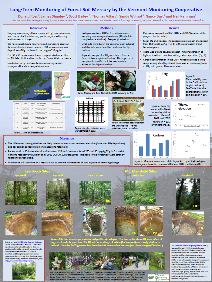
Long-Term Monitoring of Forest Soil Mercury by the Vermont Monitoring Cooperative
Donald Ross, James Shanley, Scott Bailey, Thomas Villars, Sandy Wilmot, Nancy Burt and Neil Kamman
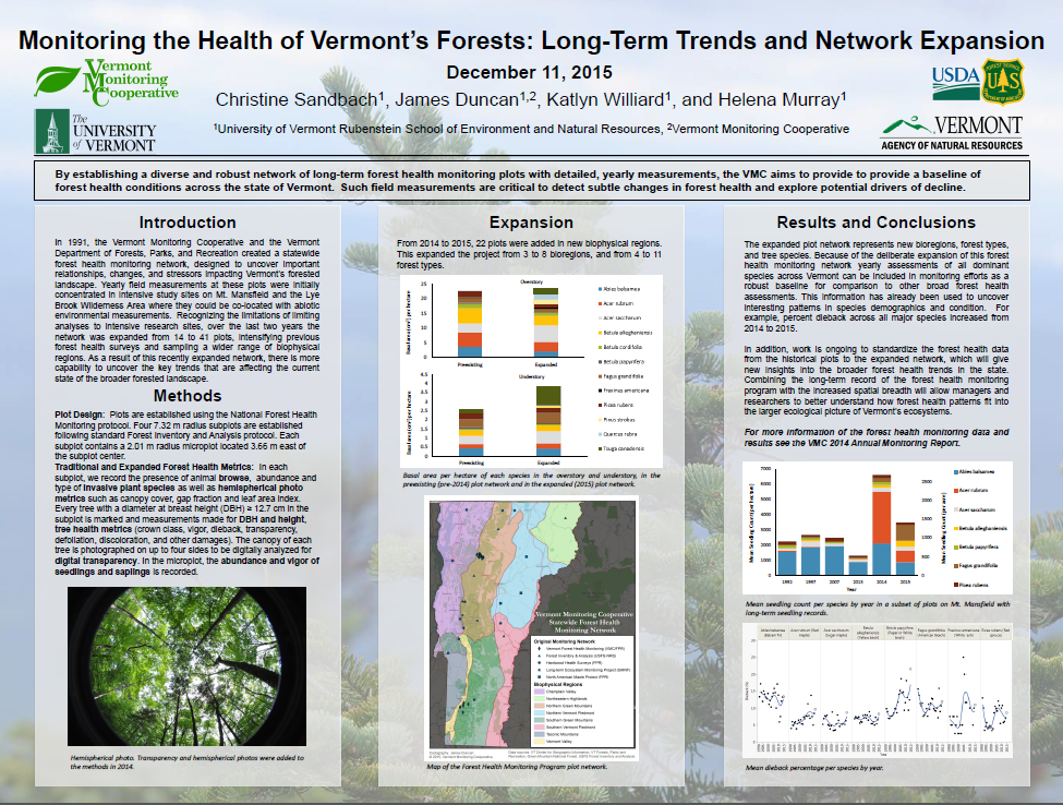
Monitoring the Health of Vermont’s Forests: Long-Term Trends and Network Expansion
Christine Sandbach, James Duncan, Katlyn Williard and Helena Murray
Natural Community Mapping: Oak and Pine Forests
Charlie Hohn, Vermont Fish and Wildlife Department
Northeastern States Research Cooperative: A Research Program for the Northern Forest
Shari Halik, Kate Baldwin, Elissa Schuett, Breck Bowden
Restoration of American chestnut: growth and winter injury of The American Chestnut Foundation's B3F3 restoration chestnut in a northern climate
Rebecca Stern, University of Vermont, Burlington, VT Paul Schaberg, USDA Forest Service, Northern Research Station, Burlington, VT Gary Hawley, University of Vermont, Burlington, VT Paula Murakami, USDA Forest Service, Northern Research Station, Burlington, VT Kendra Gurney, The American Chestnut Foundation, Burlington, VT
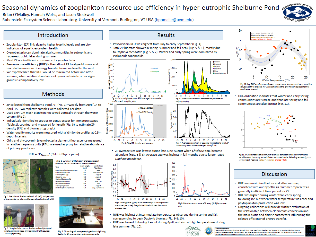
Seasonal dynamics of zooplankton resource use efficiency in hyper-eutrophic Shelburne Pond, Vermont
Brian P. O'Malley and Jason D. Stockwell
Rubenstein Ecosystem Science Laboratory, University of Vermont
Spatial and temporal trends in methylmercury in Vermont vernal pools
Vivien Taylor, Earth Sciences Department, Dartmouth College; Steve Faccio, Vermont Center for Ecostudies; Kate Buckman, Biology Department, Dartmouth College

The Power of Volunteers: Combining Invasive Plant Control with Hands-on Education and Community Service
Maria Mayer, Lisa Thornton, Heather Ewing, Elizabeth Spinney
Using Lidar to Locate Ravines and Gullies in the Rock River Watershed – following flow-paths of sediment & nutrients into Lake Champlain
Caroline Alves, USDA/NRCS
Vermont’s Acid Impaired Lakes Show Decreasing Critical Load Exceedances Based on Analysis of Recent NADP Gridded Deposition Maps
Bennet Leon, Heather Pembrook, Jim Kellogg, and Rich Poirot
Waterfowl Nesting Availability at Missisquoi National Wildlife Refuge
Boomer Malanchuk, Jacob Straub, Ken Sturm
“Monty” the buoy in hyper-eutrophic Shelburne Pond, Vermont, USA: the first year
Colin Riggs, Stephen Cluett, and Benjamin Kinnaman