
trend is
up
over time
Acid rain harms forests and other ecosystems by damaging leaves and leaching nutrients.

trend is
flat
over time
The length of the growing season varies from year to year, but large or persistent changes can be problematic to forests.
trend is
up
over time
Ozone can cause many negative impacts to forests by reducing regeneration, productivity, and species diversity.
trend is
flat
over time
Mercury is a toxin that persists in the environment for long periods by cycling back and forth between the air, water, soil and organisms - resulting in long-term, negative effects to forest ecosystems.
trend is
flat
over time
Warmer winter minimum temperatures can allow for non-native species to proliferate, while at the same time stressing native forest trees.
trend is
flat
over time
Higher maximum summer temperatures can stress forests, reducing productivity and health.
trend is
flat
over time
Changes to precipitation can alter the water balance in Vermont’s forests, causing either drought or deluge.
trend is
flat
over time
Snow insulates the soil and tree roots from cold temperatures and provides water when it melts.
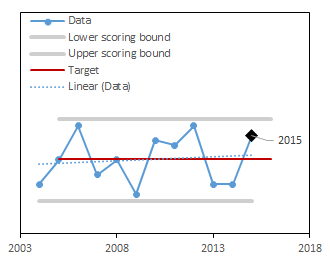
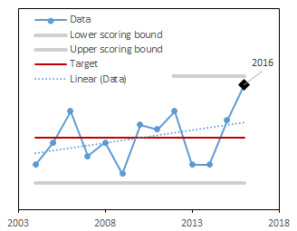
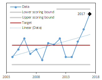
trend is
flat
over time
Climate change will continue to result in more extreme weather events, which can stress forests beyond what they are accustomed.
trend is
flat
over time
Lack of sufficient precipitation can cause both immediate and long-term stress to trees.
trend is
flat
over time
As native trees are not adapted to defending themselves from non-native, invasive insects and diseases, widespread damage and mortality can result.
Latest Score:
3.8/5
in 2019
score trend is flat over time
Changes in the proportion, extent, and severity of extreme weather events are an indication of a volatile and changing climate. Not only are extreme events stressful to forests, but they can cause significant problems for our infrastructure and health. NOAA National Centers for Environmental Information (NCEI) computes a regional Climate Extremes Index (CEI) based on the monthly maximum and minimum temperature, daily precipitation, and monthly Palmer Drought Severity Index1. The CEI is a combination of the proportion of the year and the area in the region that has experienced an extreme event for these three indices. The long-term variation or change in the CEI represents the tendency for extremes of climate to either decrease, increase, or remain the same1. Here, we set the target for the dataset as the long-term mean with the understanding that climate extremes are a natural phenomenon, but that changes away from this baseline may pose threats to both forests and humans. A High score means that there is a high number of extreme events in a given year.
Extreme events are increasing in occurrence, from extreme heat, extreme precipitation, and drought. As our world continues to warm, our climate will continue to experience these extreme events.
Additional Resources
National Climate Assessment 2014
National Climate Assessment 2018
NOAA, Northeast Regional Climate Center at Cornell University (2020)
The score is calculated using a target value and the historical range of the the entire long-term dataset. The higher the score, the closer this year's value is to the target.
Once the score is computed for each year, the trend in scores over time is calculated. If the trend is significantly positive or negative, the long-term trend is marked as increasing or decreasing respectively.
| Component | Description |
|---|---|
| Scored as | Distance away from long-term mean (scaled 1-5) |
| Target value | Long-term mean |
| Directionality of scores | No change from the long-term mean is better. |
| Minimum value used in scoring | Data minimum - 10% of range |
| Maximum value used in scoring | Data maximum + 10% of range |
NOAA National Centers for Environmental Information (NCEI) provides a robust Climate Extremes Index for the northeastern US1. NCEI computes the regional CEI based on a set of climate extreme indicators: (1) monthly maximum and minimum temperature, (2) daily precipitation, and (3) monthly Palmer Drought Severity Index (PDSI). The CEI is a combination of the proportion of the year and the area in the region that has experienced an extreme event for these three indices. NCEI has defined extremes as those CEI values that fall in the upper (or lower) tenth percentile of the local period of record. Please refer to NCEI documentation for more details on calculations. Accordingly, a value of 0% for the CEI indicates that no portion of the year was subject to any of the extremes considered in the index. In contrast, a value of 100% indicates that the entire northeast region had extreme conditions throughout the year for each of the indicators. The long-term variation or change in the CEI represents the tendency for extremes of climate to either decrease, increase, or remain the same1. We set the target for the dataset as the long-term mean. The current year is scored for where it falls between the target and the upper scoring bounds (maximum value in the dataset) or the lower scoring bounds (minimum value in the dataset), scaled to be between 1 and 5.