
trend is
down
over time
The average crown dieback of trees in Vermont's forest provides us information on overall forest health.

trend is
flat
over time
Damages to forests occur from insects, diseases, weather events, animals, and human impacts.
trend is
flat
over time
Forest growth provides information on how much biomass Vermont's trees add annually.
trend is
flat
over time
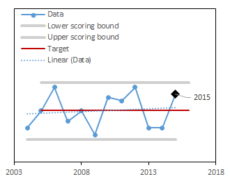
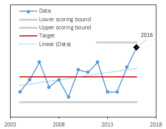
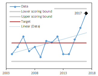
Higher values of canopy density indicate a more lush, green, and productive forest.
trend is
flat
over time
Mapped forest mortality is an assessment of the total area of current-year tree mortality across the landscape.
trend is
flat
over time
The proportion of trees with damage and decay provides information on the condition and the potential timber quality of Vermont's trees.

trend is
up
over time
Individual tree mortality is a natural and common event, but changes to the baseline rate can signify worsening environmental conditions for trees.
Latest Score:
5/5
in 2018
score trend is flat over time
Canopy density or ‘greenness’ is estimated using data collected by the MODIS1 satellite mission, and represents the thickness of the forest foliage. MODIS captures bimonthly imagery of Vermont’s forests which are then aggregated across the full growing season. Canopy reflectance at different wavelengths is used to calculate a normalized difference vegetation index (NDVI), which is an assessment of overall greenness of the forest canopy. Higher greenness is associated with a greener and more photosynthetically-active forests. A higher score means that canopy density is staying high over time.
1 NASA MODIS . Available at: https://modis.gsfc.nasa.gov/
Because canopy density values for a healthy forest vary across forest types, here we interpret canopy density on a relative scale and focus on changes over time rather than raw density values. This approach shows that while growing season canopy density varies from year to year due to various stress agents (e.g. pest outbreaks, drought, etc.), overall the growth and health of Vermont’s forests as captured by canopy density has remained consistently high over the 15 year data period, with 2018 reporting the highest yearly average to date.
Jennifer Pontius. Research Ecologist, US Forest Service; Principal Investigator, Forest Ecosystem Monitoring Cooperative (2020)
The score is calculated using a target value and the historical range of the the entire long-term dataset. The higher the score, the closer this year's value is to the target.
Once the score is computed for each year, the trend in scores over time is calculated. If the trend is significantly positive or negative, the long-term trend is marked as increasing or decreasing respectively.
| Component | Description |
|---|---|
| Scored as | Distance between the minimum and maximum (scaled 1-5) |
| Target value | Data maximum |
| Directionality of scores | Higher values in the data are better |
| Minimum value used in scoring | Data minimum - 10% of the range |
| Maximum value used in scoring | Data maximum + 10% of the range |
Using MODIS phenology remote sensing products, we selected the Time Integrated (TIN) Normalized Difference Vegetation Index (NDVI) to quantify maximum canopy greenness over a growing season1. Available TIN images began in 2001. We first excluded all pixels with a value of either 0 where no chlorophyll was detected throughout the growing season, or 255 for water or areas of no data. Using National Land Cover Dataset (2011), we created a forest cover layer by masking out all non-forest pixels (i.e. those not identified as forest/woody wetlands [values 41, 42, 43, 90]). We used this forest mask to compute the mean TIN and standard deviation of the mean TIN across all forest-cover pixels per year. We set the target for this dataset as the maximum value. The current year was scored based on where it falls between zero and the target, scaled to be between 1 and 5.
Dataset: MODIS TIN Yearly Mean and STD