
|
|
|
|
|
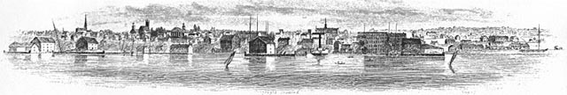
The North Union Street--South Union Street corridor we see today did not exist as a continuous roadway in 1853. The portion of present-day North Union Street running from Winooski Avenue south to Pearl Street appears on that year's Presdee & Edwards map of Burlington under the name of Maiden Lane. The same map shows "Union Street" running only from Main Street south to Shelburne Road. The land between Maiden Lane and Main Street was a deep ravine occupied by the Vermont Central Railroad line and depot.
The ravine was an inconvenience for merchants seeking to transport goods by road through Burlington and a natural barrier to the expansion of the business district eastward, and by the 1850's there were concerns about the impact of open sewers that drained into the ravine. It was only after the relocation of the Vermont Central Railroad to the Intervale and the filling of the ravine in the period following the Civil War that the connecting portion of the North Street--South Union Street roadbed was constructed. (1)
As a result of the physical gap created by the ravine, the Union Street corridor in 1853 was characterized by two separate and distinct residential neighborhoods: middle-class Maiden Lane (today's North Union Street, north of Pearl Street) and upper-middle-class Union Street (present-day South Union Street, particularly the portion south of Main Street).
Maiden Lane benefited from its proximity to Pearl Street, the town's wealthiest street in the Federal Period and a "quiet street of handsome residences" in the mid-nineteenth century, which provided an easy transportation route from Maiden Lane to businesses in downtown Burlington. (2) The first Burlington city directory (1865) lists numerous tradesmen who resided on Maiden Lane and had businesses nearby or in the downtown area, including a hat and cap seller, carpenter, grocer, photographer and blacksmith. (3)
Union Street south of Main Street had long been a major transportation route from the center of Burlington to points south along Shelburne Road. Residential development on Union Street began circa 1835 when a string of Greek Revival houses were built, mostly near Main Street, for a generally upper-middle-class clientele. (4) The portion of the Union Street corridor around College and Main Streets also attracted wealthy residents in the mid-nineteenth century. (5)
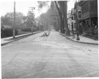
View south on South Union Street from Main Street, early 20th century (McAllister photo courtesey of the Special Collections Department of the University of Vermont Libraries):
(2) Vermont Historic Sites and Structures Survey: Burlington -- Pearl Street.
(3) Burlington City Directory and Business Advertiser, 1865.
(4) South Union Street Historic District, National Register of Historic Places Inventory-Nomination Form.
(5) Vermont Historic Sites and Structures Survey: Burlington -- College Street; Vermont Historic Sites and Structures Survey: Burlington -- Main Street.