For over 160 years, the University of Vermont has served as a steward of Vermont’s highest peak. This involvement has evolved from a pioneering act of 19th-century conservation into a globally recognized hub for mountain research and ecological monitoring.
A Pioneering Vision (1859–1900)
UVM’s commitment to Mount Mansfield began in 1859 with the purchase of the 400-acre summit ridgeline. An article published by the Vermont Historical Society covers this history well. At the time, the university was facing significant financial hardship, making the decision to invest in land conservation all the more remarkable. This move to protect rare alpine species occurred 13 years before the establishment of Yellowstone National Park and predated UVM’s status as a land-grant institution. This acquisition makes UVM an early leader in the American land conservation movement.
Cold War Defense Dispute (1958)
In 1958, Mount Mansfield’s summit became the focal point of a Cold War defense dispute when the U.S. Army Corps of Engineers proposed a missile communications and control facility on "The Chin." This installation was intended to coordinate a regional network of Atlas F ICBM silos. The proposal required significant blasting and leveling of the summit, which would have irrevocably altered the highest point in Vermont and destroyed the fragile alpine ecosystem.
The plan faced immediate opposition from the Green Mountain Club and University of Vermont faculty, most notably botanist Hubert "Hub" Vogelmann. They argued that the facility would compromise the wilderness integrity of the Long Trail and the mountain's rare tundra. By late 1958, the Air Force abandoned the project in favor of alternative technical solutions. This successful resistance served as a pivotal moment for Vermont conservation, catalyzing the formal protection of the summit and leading to the eventual establishment of the Mount Mansfield Natural Area.
The Rise of Alpine Science (1950s–1970s)
The mid-20th century transformed the mountain into a site of active infrastructure and data collection. In 1954, UVM leased land to WCAX for broadcasting antennas, followed by the installation of a weather station and the iconic snow stake that same year. During this era, Dr. Hub Vogelmann became a vocal advocate for the mountain’s fragile ecosystems. His 1964 work, Natural Areas in Vermont, identified Mount Mansfield as a site of supreme ecological significance. This advocacy culminated in 1974 with the formal establishment of the UVM Natural Areas system, which incorporated the university’s Mansfield holdings to ensure their permanent protection.
Intensive Monitoring and Partnerships (1990–2010)
In 1990, the mountain’s role as a "living laboratory" was formalized when Senator Patrick Leahy secured funding to establish the Vermont Monitoring Cooperative (now the Forest Ecosystem Monitoring Cooperative). Mount Mansfield was selected as an intensive monitoring site, leading to decades of critical research. Monitoring efforts included an intensive alpine plant inventory (1992), long-term soil monitoring, forest health and phenology tracking, mid-elevation meteorological stations, and long-term monitoring of alpine birds; most notably the Bicknell's Thrush.
The Effort to Establish a Field Station (2011-2025)
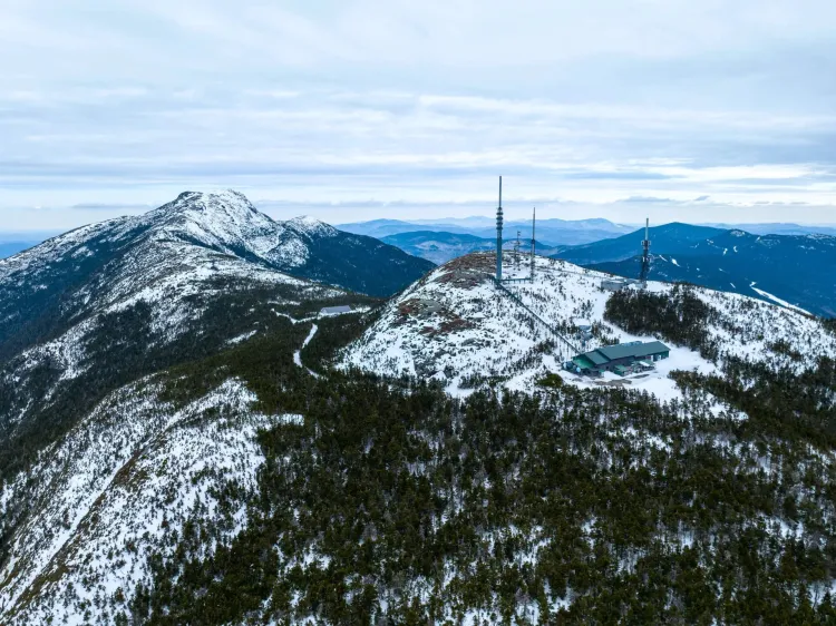
Beginning in 2011, UVM spearheaded an ambitious vision to establish the Mount Mansfield Science and Stewardship Center (MMSSC) by renovating the "Summit Station," a 2,560-square-foot former telecommunications building situated at 3,850 feet. The goal was to transform this vacant structure into a collaborative hub for environmental outreach and high-altitude research, providing onsite laboratories and lodging for up to 20 scholars and students. This proposal included high-efficiency, LEED-standard renovations and complex infrastructure plans designed to connect the remote site to municipal wastewater lines.
Despite rigorous planning and a clear institutional mission and a funding source, the project ultimately faced significant permitting challenges related to high-elevation construction and adjacent fragile alpine plant communities. While these hurdles prevented the physical field station from coming to fruition, the process underscored the role state permits play in governing Vermont’s sensitive alpine ecosystems. Future opportunities may still be possible if there is enough momentum to reconsider how these unique sites can be repurposed for climate and ecological research while aligning with state regulations.
UVM's Key Long-Term Monitoring Resource (2022 to Present)
Building on the foundation of the Summit to Shore (S2S) Environmental Observation Network established in 2022, the University of Vermont has expanded its reach through the Northeast Network of Mountain Observatories (NENMO) funded by a EPA Environmental Network grant. This regional network brings together the monitoring expertise of the Mount Washington Observatory (MWOBS) in New Hampshire and the SUNY Albany’s Atmospheric Sciences Research Center (ASRC), which operates the Whiteface Mountain Observatory. By integrating high-resolution data from across these three states, the partnership provides a comprehensive look at the unique atmospheric conditions that define the Northeast’s highest peaks.
A primary goal of this collaboration is contributing to the Unified High Elevation Observing Platform (UHOP), an international effort to enhance mountain weather and climate data globally. As NENMO works toward international accreditation, it is aligning the region’s research with global protocols to improve climate change modeling and extreme weather forecasting. By refining lapse rate calculations (the precise measurement of how temperature drops as elevation rises) the network allows forecasters to improve forecasts and researchers to better predict how shifting weather and climate will impact regional water supplies, alpine biodiversity, and the winter economy.