Dummerston
Hydrology
Though it might not be readily apparent, water is one of the major factors in shaping the Dummerston landscape. Because of its fluid nature, water always seeks the path of least resistance, impelled by the force of gravity; yet given enough time, its persistence wears away sediments and carves through rocks, defining many surface patterns of the solid terrain. On rare occasions, dramatic storm events can cause flooding and sediment slumping that transforms large swaths of topography overnight.
The most obvious surface water features in town today are the Connecticut and West Rivers, whose waters and valleys historically – and still today – serve as physical and political boundaries, recreation sites for swimming, boating, and angling, aquatic wildlife habitats, and sources of food. The floodplain of the Connecticut River, in particular, has proven to be an indispensable asset in cultivating the prime agricultural lands of the southeastern part of the state. Both rivers also function as crucial linkages to the greater regional landscape, providing transportation routes for humans, animals, material goods, and ideas.
Smaller waterways in town have also had their share of glory. Three of the major streams running through “Little Connecticut” are Stickney Brook in the southwest corner of town, Salmon Brook which courses from the north southward towards Dummerston Center and then along East-West Road, and Canoe Brook in the northeast part of town.
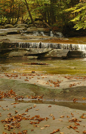
Stickney Brook
These upland waterways are rocky, woodland streams, carving steep-sided ravines through Dummerston’s hills. In the days before electric power, the location of streams like these defined the hubbub and development of industrial life in New England villages. By building dams to harness the water’s potential energy, settlers had access to a source of local power for grinding grains, milling sawlogs, and cleaning wool for textile fabrication. Slab Hollow, for example – the narrow valley of Salmon Brook along East-West Road – was a hotbed of early settlement activity. Today with most electricity being generated by external sources and transmitted by power lines across the countryside, there is little utilization of small-scale hydro-power, and the once-thriving mill towns have receded into the depths of history and the woods.
Damming of waterways has not been limited to the smaller streams, however. In a similar fashion, both the Connecticut and West Rivers have been dammed (though not within Dummerston borders), largely for the purposes of flood control and to a lesser extent, energy production. While beneficial in some ways to humans, damming has had detrimental impacts on several populations of native fish species which historically migrated upriver each spring in order to spawn, including Atlantic salmon, American shad, and striped bass. In recent years Federal Fish and Wildlife programs, in conjunction with local community groups, have taken the lead to repopulate the rivers with migratory fish. Beyond scales and fins, the forested riparian areas along the banks of Dummerston’s streams and rivers, ponds and swampy areas are home to a great diversity of critters, including crayfish and turtles, green frogs, snakes, minks, otters, beavers, wetland birds like ducks and herons, and a host of other animals that come to the water to drink, hunt, or fish.
Scattered about town are also innumerable minor hydrologic features, such as ephemeral melt water streams, seeps, ponds, and springs. Though small in scale, they have a big impact on localized vegetation patterns. Where ready water sources are lacking, such as on Black Mountain, the climate conditions are dry and not conducive to prolific plant growth. The moist gullies of hillside tributaries, on the other hand, are often flushed with a diversity of verdant ferns and wildflowers. Many surface waters also infiltrate into the earth and connect through subterranean passageways with large underground reservoirs that serve as important water sources for daily drinking and household needs.
As a final note, bear in mind that water is not a static entity. The hydrologic patterns we see in Dummerston today have continually been changing since the glaciers departed southern Vermont some 14,000 years ago. As the streams and rivers wind their way across the land, they will continue to redistribute sediments and sculpt the topography in yet unknown ways for millennia to come.