Dummerston
Bedrock Geology
Consider this: Most of the bedrock beneath your feet in Dummerston predates the time when plant life populated the dry land on earth! How old are these rocks? Geologists tell us that the bedrock of Dummerston began forming more than 350 million years ago, during a period known as the Devonian. At that time, the land we now know as Dummerston (and indeed much of Vermont) was actually part of the sea floor beneath the ancient Iapetus Ocean. Sediments from the surrounding highlands had been eroding for millions of years into the ocean basin, accumulating and compacting into sedimentary rocks. These sediments varied in size, from sands, to silts and clays, and in mineral composition as well. Some of the rocks were limestone made of calcium materials extracted by tiny marine organisms floating in the water, while still others formed as igneous materials from ancient lava flows.
Then great tectonic forces over the course of 50 million years resulted in the collision of the Northern European and North American continents. This event – known as the Acadian Orogeny – was one of several massive impacts that eventually resulted in all of the earth’s continents being combined in a super-continent called Pangaea. The result of this collision was that the rocks of the shallow marine basin were thrust up into massive peaks. Geologists estimate that in the millions of years since these major land-forming events ceased, erosion has worn down the mountains to their current elevation. Nevertheless, the intense heat and pressure of rocks smashing together metamorphosed the sedimentary and igneous rocks into new rock types called slate, phyllite, schist, amphibolite, and marble, and folded or broke rock layers into tilted and jagged angles.
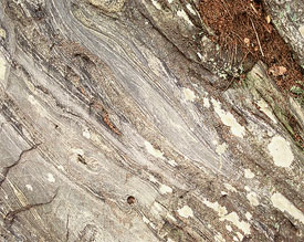
Pictured here is an outcrop of a rock type called amphibolite, part of the Standing Pond Volcanics formation. The outcrop appears in a road-cut along East-West Road, west of the town center, and was formed when an ancient basaltic lava-flow was heated and crushed during one of the continental collisions involved in the assembly of Pangaea.
Geology helps define both the shape and the substance of a region’s terrain, and in Dummerston we see a diversity of formations and rock types distributed across the landscape, which helps account for the variability of landforms and ecologic properties (See bedrock map). Much of Dummerston's bedrock is deformed, wavy-looking schist, mixed in with layers of impure marble (containing both calcium carbonate and quartz sand), and a metamorphic rock called amphibolite that formed from volcanic lava. The marble tends to be highly weathered, giving it a punky, porous texture, and resulting in few noticeable outcrops around town. You’re more likely to find it as chunks of weathered rock in a stream bed such as that of Stickney Brook. Amphibolite is exposed nicely in outcrops along East-West Road, and many cobbles of schist can be found in the stone walls of Dummerston’s early settlement history, like the one along the trail up Prospect Hill.
Some of the rocks that formed during the Acadian Orogeny are of high enough quality that for a time they were utilized for human industrial purposes. The old quarry along the eastern side of Route 5, just south of Dutton Pines State Park, was dug out of fine slate deposits that are part of the Littleton Formation. These slate slabs were used for roofing and chalk boards, among other things. The quarry dates back to at least the mid-19th century. Not all of the rock in Dummerston is metamorphic in nature, however. Black Mountain, situated in the southern central part of town, is a pure mass of granite, an igneous rock that formed as a balloon of liquid magma below the surface of the earth as a result of melting caused by continental impacts. The magma cooled into a giant dome of erosion-resistant rock, which was later exposed as the softer rocks on top eroded away. The injection of magma 350 million years ago has also had a significant impact on Dummerston’s recent human history and social character — providing the raw materials for the quarrying industry that was a major part of the town’s economy in the late 19th and early 20th century.
The underlying bedrock is also important in shaping the character of the overlying ecology present on the landscape today. Steep terrain in the hills makes for fast-flowing, rocky streams, and the resistant granite of Black Mountain has redirected the West River around its western flank. Natural communities of plants like the Rich Northern Hardwood assemblage thrive on calcium enriched substrates of the Waits River Formation, while the Pitch Pine-Oak-Heath Rocky Summit community persists only on dry, nutrient-poor granites.