Analyze Your Town’s Physical Landscape

The physical landscape should be the starting point for your investigation of your town’s natural and cultural history. We can think of the physical landscape as the stage that supports the cast of human and non-human characters, the actors in an ever-unfolding story.

The Winooski River corridor through the Green Mountains
The Winooski River corridor through
the Green Mountains
Built of bedrock, surficial sediments, soils, topography, hydrology and climate, the physical landscape has been shaped by enormous geologic forces over millions of years. Since the retreat of the glacier from the Vermont landscape 12,000 years ago, many casts of characters have interacted and migrated across this relatively stable backdrop; plants and animals continually shift and evolve in response to their stage, the physical environment.

Indeed, the nature of the physical landscape often defines and limits the distribution of plants, animals and people across the landscape. Climate and topography are two major factors that control a landscape’s exposure to sunlight and precipitation. Even locally, the shape and character of bedrock and surficial sediments will determine where certain plants and animals can thrive. For example, in Vermont, you are almost certain to find balsam fir trees at a lower elevation on the north face of a mountain than on the south face of the same mountain. Perhaps at the base of this same hill there is a sunny limestone outcrop, and here you are sure to spot patches of ebony sedge and wild columbine thriving in the well drained, more basic soil.

Aspects of the physical landscape have long controlled the distribution of people as well. Think of the Winooski River as it cuts through the steep Green Mountains. This river corridor provides a sheltered and easily navigable path across the central part of the State, and also provides a rich floodplain for farming. The fact that a busy interstate, miles of agricultural fields, and a wide meandering river occur side by side is no coincidence.

Below are our general descriptions of five physical landscape features (bedrock, surficial geology, soils, topography, hydrology, and climate) focusing on Shelburne, Vermont for our case study.

Physical Landscape History, Overview, and Features

» A brief history and overview of Vermont’s physical landscape

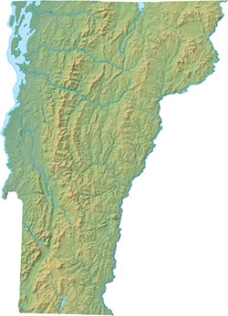
A Brief History and Overview of Vermont’s Physical Landscape

The story of Vermont begins thousands of millions of years ago. However, we can gain some understanding of Vermont’s most striking physical landscape features by focusing on just three major events:

  • the formation of the Iapetus Ocean 575 million years ago
  • the Taconic Orogeny that began approximately 450 million years ago
  • the most recent cycle of glaciations that ended 13,000 years agos

The Formation of the Iapetus Ocean

diagramlink

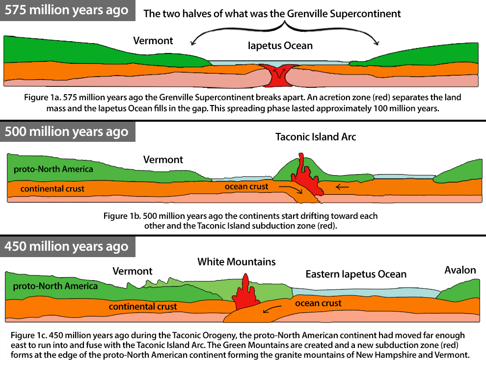
The Iapetus Ocean formed as a rift began to widen in the Grenville Supercontinent about 575 million years ago. This ocean was in the same relative position to the newly forming proto-North American continent, as the Atlantic Ocean is to North America today, except that the entire formation was shifted thousands of miles to the south. For about 100 million years the Iapetus Ocean existed as a wide shallow tropical sea and sediments eroded from the proto-North American continent and settled onto the sea floor. Over time these sediments compressed and lithified, forming large slabs of limestone, sandstone and shale.

The Taconic Orogeny

About 500 million years ago, the continents on either side of the Iapetus Ocean began drifting back together. The result was a subduction zone along the edge of the proto-North American continent. Volcanoes lined the subduction zone and formed the Taconic Island Arc at the continent’s edge. As the continents continued to move toward each other the chain of volcanic islands collided and fused with the eastern edge of proto-North America. The collision of the Taconic Island Arc with proto-North America is called the Taconic Orogeny. This was an extensive mountain building period. Rocks such as the limestone and shale that formed at the bottom of the Iapetus Ocean, were subjected to high heat and pressure and metamorphosed to varying degrees. Today we can find these rocks (schist, marble, sandstone, quartzite, limestone and shale) throughout the Taconic and Green Mountains of Vermont. It is interesting to note that Vermont’s mountains today are merely the remnants of the much larger mountain chain formed by the Taconic Orogeny.

You might wonder about the granite that is found in the Northeastern part of the state. The granite is an igneous rock that was created toward the end of the closing of the Iapetus Ocean as yet another subduction zone formed where the two continents were colliding. Unlike the Taconic Island Arc, the magma that rose up from during this event never reached the surface of the earth. Instead, the magma cooled underground and created the large plutons of granite. Over time these plutons were pushed to form the White Mountains and Vermont’s Northeastern Highlands.

Glaciation

Mountain building in Vermont subsided approximately 200 million years ago. Consequently, erosion is the main process that continues to shape the physical landscape of Vermont. One consequence of the massive erosive power of a glacier is that it wipes out much of the evidence from the previous glacial event. So we will focus on the most recent period of glaciation that began about 90,000 years ago. This was the beginning of the Wisconsin Glaciation. As global temperatures drop, snow accumulates faster than it can melt and forms thick ice sheets. For 70,000 years or so these ice sheets flowed south, redistributing enormous quantities of soil and debris as they went. The largest ice sheet that formed during this period was the Laurentide ice sheet; it covered much of Eastern North America, and was over a mile thick in places.

Camels Hump
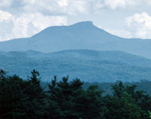
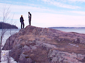
Camels Hump, a classic “roche moutonée”

Vermont was completely buried by the Laurentide ice sheet. The erosive power of this glacier made the surface of Vermont’s landscape what it is today. Because of all the debris that glaciers carry, one can think of an ice sheet as a mile-thick piece of sand paper. A glacier will creep through a narrow gorge and leave it a wide scraped out valley. As glaciers push up and over steep mountains they smooth out front side, and pluck away debris from the leeside. This process is what formed Vermont’s characteristic “roche moutonée” topography. Camel’s Hump is a classic and well-known example, with a sloping north face and very steep south face.

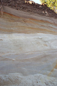
Many major landscape changes occurred as the glacier retreated as well. Glaciers leave behind huge quantities of debris and sometimes, more importantly, water. About 20,000 years ago global temperatures began to rise and the Laurentide ice sheet started its retreat and by 13,000 years ago the ice sheet had retreated north to southern Quebec. During this slow retreat, several temporary rivers and lakes formed in Vermont’s lowlands. Not only was there lots of melt water inundating the state’s valleys, but the weight of the ice had depressed the continental crust so much, that what is now Lake Champlain was temporarily a small inland sea connected to the Atlantic Ocean via the St. Lawrence River. We can still see evidence of these glacial rivers, lakes and sea in the enormous amounts of erosion, sediments, and fossils they left behind.

Recommended Reading: The Story of Vermont: A Natural and Cultural History C. M. Klyza and S. Trombulak, University Press of New England 1999.

For an excellent overview of Vermont’s physical landscape, also visit: The Landscape Change Project

» Bedrock Geology

Bedrock is the foundation of the Vermont landscape, as well as its oldest component. Composed of minerals that formed in the earth’s crust and ancient oceans, bedrock provides the raw material that forms soils and nourishes plants and animals. Although usually buried from view by overlying sediment, soil, and vegetation, the underlying bedrock also controls much of the landscape’s topography, and consequently plays a major role in determining the human and natural history of Vermont. The minerals found in different kinds of bedrock are often commercially valuable, like the talc that was mined from the marble quarry near Rochester. Or the rock itself might be valuable, as in the case of the granite found near Barre. The structural and chemical nature of rock also affects soil structure and chemistry. Limestone for example is a carbonate-rich rock. As it weathers it provides many important nutrients for plant growth such as calcium and magnesium. These cations also buffer soil acidity and thus aid plants in nutrient uptake.

Bedrock in Shelburne
Bedrock outcrop bordering Shelburne Bay

Certain plants, such as ebony sedge and wild columbine, thrive in this more neutral soil environment. In contrast some bedrock types, such as serpentine, contains minerals like nickel and chromium that are so hostile to plant growth that only the hardiest plants can thrive on the soils that develop there. It is common to find poverty grass and harebell in these environments.

Vermont’s geology is diverse and complex, and not all of the bedrock maps have been updated to provide the most recent interpretation of features. However, the 1961 paper map produced by the Vermont Geologic Survey is an excellent place to start. You can also check the VCGI website to see if your community’s bedrock map has been digitized, which will allow you to hone in on updates and information about your specific area. Once you have a basic map of your area, go for a walk or drive and keep a sharp eye out for rock outcrops. Look for both the general form (is it sharp and blocky or round and blob-like) as well as the close-up details (Can you see crystals or layers? What size are they?). As you find outcrops, don’t forget to notice the other features found nearby such as a stone foundation, a grove of sugar maples, or a small porcupine den.

Shelburne’s Bedrock Geology

pebbles
The bedrock geology of the town of Shelburne, Vermont is fascinating and diverse. If you walked from the shoreline of Lake Champlain to the eastern boundary of the town, it would be possible to encounter as many as 12 distinct bedrock formations during your journey, including shale, quartzite, limestone, and dolostone. Almost all of these formations (with the exception of the igneous intrusions along the shoreline of Lake Champlain) originated as sediments on the shoreline and floor of the Iapetus Ocean, the precursor to the modern day Atlantic, which existed around 500 million years ago. The tectonic forces that closed the Iapetus Ocean and uplifted the Green Mountains also metamorphosed these rocks, and even fractured the earth’s crust, shoving older layers over younger layers, as is manifested by the Champlain Thrust Fault that runs north-south through the western part of town.

Bedrock geology map-Shelburne
Bedrock geology map of Shelburne
Bedrock Shelburne
Cross-sectional interpretation of Shelburne's bedrock

More Resources

» Surficial Geology

The surficial geology of Vermont is largely a legacy of the glaciers that receded from this area about 13,500 years ago. Glacial till, gravel, sand and clay are the most common surficial deposits that remain from the retreat of the glaciers. These deposits are smeared across hillsides, and even fill whole valleys. They may be several feet thick and create structure and form independent from the underlying bedrock.

Understanding the surficial geology of your town is critical to conducting an effective landscape analysis for a number of reasons.

surficial sediments
Surficial sediments exposed along a stream bank

First of all, surficial deposits generally provide the “parent material” for the soils that have been developing over the last 10,000 years. The texture and chemical composition of this parent material has a profound influence on important factors such as soil productivity and moisture holding capacity, and often holds the key to understanding patterns of agricultural activity and plant community distribution. In addition, surficial deposits are often quarried for their commercial value (i.e., sand and gravel), and, because of variations in depth and drainage, often control where development can (and cannot) occur. For example, sand deposits (often originally deposited as deltaic and shoreline environments) generally make for poor agricultural soils because they provide scant nutrients and don’t retain adequate moisture, yet are often prime for development because they easily excavated and eminently suitable for septic drainage.

Glacial till, a jumbled and unsorted mix of different sediment sizes (ranging from clay to boulder), is by far the most common surficial deposit on the Vermont landscape. Originally scraped from the bedrock and redistributed on the landscape under the advancing ice sheet, till (ironically derived from the Scottish term meaning “stubborn land”) tends to give birth to soils that are rocky and dense, and often somewhat poorly drained. The rocky and often acidic nature of these soils often led 19th century Vermont farmers to abandon them in favor of soils that were more fertile and easier to plow.

In the lowlands of Vermont (i.e., the Champlain Valley and the major river valleys), till is commonly mantled by finer sediments, such as sand, silt, and clay. This pattern is a manifestation of the sorting power of flowing water. As the glacier melted away from the landscape, tremendous amounts of glacial meltwater flowed through the recently uncovered till, and carried and sorted the component particles varying distances from their source, depending on the size of the particle and the energy of the flow. Cobble-sized rocks require very fast, high energy flows to move them, while smaller sand particles can be easily transported by fast flowing water, but are quickly deposited when the rate of flow slows, such as when a flowing river meets a still lake. Microscopic clay particles, however, will often be carried long distances into still, deep water. When these finer particles are found at the surface of the landscape, it is often evidence that a glacial lake covered the area at the end of the Wisconsin Glaciation.

Sometimes surficial sediment is exposed in road cuts or riverbanks, but usually the best way to explore the surficial sediments of your area is to start digging. You’ll want to look for transitions in soil color and texture, notice the shape and size of any rocks that you encounter, and depth and nature of plant roots. As always, keep your eye on the surrounding features - natural and human-made.

Shelburne’s Surficial Geology The surficial geology of the Town of Shelburne, which is dominated by silt, clay, and sand, is a reflection of the fact that it’s landscape was completed covered by Glacial Lake Vermont immediately following the retreat of the Laurentide ice sheet.

glacial till
Exposed glacial till
This vast glacial lake covered the Champlain Valley to elevations 600 feet above present day sea level, and its presence led to the mantling of the previously deposited till with deep deposits of fine silts and clays. Large swaths of marine sand cover these lake bottom sediments in general area between Route 7 and spear street, a manifestation of the shoreline of Champlain Sea (an inland arm of the Atlantic Ocean) that inundated the Champlain Valley to elevations 320 feet above present day sea level for several hundred years following the retreat of the ice sheet. Interestingly, the underlying glacial till is exposed in areas where streams have down-cut through the overlying sediments. (see photo at right) This till is largely composed of the local shale, limestone, and quartzite that makes up the bedrock of Shelburne. Pluvial deposits derived from slowly decomposing organic matter form the parent material for wetland soils found in the vicinity of Shelburne Pond and the LaPlatte River.

» Soils

Soils are the interface between mineral geology and life. They are formed through the physical and chemical weathering of parent material (bedrock or surficial sediments.) The addition of decomposed organic material, air and water will further speed the soil building process. In some places like the tropics, soils have been forming for millions of years, but in a glaciated landscape such as Vermont, the most soils are a mere 13,500 years old. No matter how old they are, soils continue to develop as long as there are organic and mineral resources available. Some soils form more rapidly than others, and in some cases, such as soil formation in floodplains, it is one of the few geologic processes that we can observe on in our own lifetime.

Collecting soil samples
Collecting samples from different soil horizons

Soil supports plant growth in several ways. It provides a substrate for plants to anchor their roots, and, depending on its composition, it supplies varying amounts of water, air and nutrients for the plant as well. Of the eight essential plant nutrients five are derived from soils. How much and which kinds of nutrients are available in the soil depends largely on the chemistry of the parent material. Soils that have a high clay or organic material content tend to have the largest amount of biologically available nutrients. In contrast, soils that are mostly sand, gravel or silt are more inert and provide fewer nutrients for plants and animals. In both cases weathering is the process that causes the break down of material and makes the nutrients available to living organisms.

What soils form where and how they affect the landscape is a broad and complex science. Most soil scientists use a soil classification system that organizes all of the world’s soils into eleven orders. These orders are further broken down until they are finally split into families and series. The characteristics used to identify soils include grain size, moisture, existing soil horizons, mineralogy and sometimes temperature. Soil series are named after the location where the series was first described. As you become familiar with the soil series of your area, look for connections between soil type and land use.

The Soils of Shelburne

The diversity expressed by the 30 different soil series found in the town of Shelburne is largely a reflection of the landscape’s underlying geology. Many of the soils in town have a high silt and clay content, which is not surprising given the fact that the entire landscape was covered by a glacial lake at one point. Soils rich in clay have the potential to be nutrient-rich due to the high cation exchange capacity and the negatively-charged clay particles. They also tend retain moisture well (sometimes too well for a farmer trying harvest crops from muddy field).

Many of the soils in Shelburne also tend to be rich in nutrients because of the calcareous nature of the underlying bedrock, which has a neutralizing effect on the pH of the soil. This is especially true on the ridges and knolls in town where calcium-enriched glacial till (and/or bedrock) is at or near the surface. This enrichment is clearly reflected in the natural vegetation of these area, which tend to be dominated by “rich-site indicators” such as American basswood, butternut, maidenhair fern, bloodroot, wild ginger, and blue cohosh. In the areas immediately surrounding the mouth of the Laplatte River and Shelburne Pond, the wetland soils are categorized as peat and muck.

» Topography

Relief Map
Relief Map of Vermont
Click to View More
Topography is the configuration of the earth’s surficial features. This includes relief and the relative positions of natural and human-made features. Large natural landforms, such as mountain chains and oceans, influence hydrology, climate, and glaciology over entire continents. Smaller scale relief, like that created by surficial sediments or human development, will affect the temperature, moisture and hydrology of the local environment. At a large scale relief determines the altitude at which an environment exists, and at a small scale it affects the slope and aspect of the local landscape.

Slope and slope aspect are important features of topography. A steep slope or cliff will drain more quickly and retain less organic material than a flatter area in the same region. So on steeper areas we can expect less soil to develop and consequently fewer plants to thrive. Of course there are always exceptions, and in Vermont, you often find a thick fringe of Northern white cedar growing on well-drained rocky slopes. Slope aspect directly affects an area’s exposure to sunlight and precipitation. We can see the affect of this on Vermont’s landscape when we find more southerly species (such as red oak) competing well on drier, warmer south and west facing hillsides.

Because of the important role that topography plays in shaping the physical and biological environment, topographic maps are an excellent resource for interpreting your local landscape. You probably already have a good feel for the major topographical features of your town but you can start to look for clues about how your community and the landscape have been shaped by these features. For example, where are the oldest houses in town? Do people prefer to garden on one side of their house or another?

The Topography of Shelburne

Located along the shores of Lake Champlain and squarely within the Champlain Lowlands, the town of Shelburne has relatively little relief compared to other towns in the state. Lake Champlain, the town’s western boundary, has a mean water level of approximately 97 feet above sea level. The highest point of land in Shelburne (on the ledges just east of Shelburne Pond) is 456 feet above sea level.

Despite its lack of large-scale topographic variation, the presence of a number of low hills ridges, and stream valleys in Shelburne contributes to a remarkable diversity of habitats within the town’s borders. Some of this diversity is derived from the influences of aspect on area such as Allen Hill, which rises on the western shore of Shelburne Bay. For example, a rich oak-hickory-northern hardwoods forest occupies a blocky talus slope on the cool north side of the hill. In contrast, the hill’s drier south slope supports an oak-pine forest with an unusual concentration of chestnut oak (Quercus prinus).

Resources

» Hydrology

Hydrology includes all of the water features of a landscape including lakes, ponds, rivers and streams, as well as underground water and precipitation. Water distribution both above and below the earth’s surface is critical to the survival of plants and animals. Hydrology is such an important factor in determining the distribution of plants and animals that ecosystems and natural communities and landforms are often shaped by their hydrological regime. Vermont’s floodplain forests, deltas and bogs are all sustained by specific hydrological regimes. Hydrology has a huge impact on soil structure and composition, but soil structure can also have an effect on the hydrology of an area as well.

Because humans, plants and wildlife depend so much on the availability of fresh water, many landscape analysts break up the landscape into functional hydrological units called watersheds. A single major hydrological feature such as Lake Champlain or the Connecticut River can define a regional watershed, while smaller features such as ponds and streams can define sub-watersheds. Topographical features like mountain chains affect surface hydrology and so also play a role in defining watersheds.

You might start your exploration of hydrologic features by starting with your own faucet. Find out the source of your town’s drinking water, and put the source into the context of your local watershed. Use a surface water map or aerial photograph to identify small streams and drainages and then explore these areas. Be sure to notice the land use strategies along the banks and watch for signs of wildlife both in and out of the water.

» Climate

Climate describes the overall patterns of weather observed in an area. All together, air temperature and pressure, humidity, cloudiness, precipitation and wind create weather patterns, or climate. From precipitation to wind and ice,

Winter Ice
Winter ice on Lake Champlain
weather is a process that affects the landscape at every level. Until recently we perceived the global climate and its resulting weather regimes to be fairly stable. But examination of pollen and arctic ice cores has shown us that climate change is inevitable. We know for example that Vermont was once much, much colder, and was buried under a mile of ice. We also know that historically plants and animals have been able to adapt to climate change by migrating to more hospitable areas, but that some periods of rapid climate change coincided with mass extinction events.

Though we are due for another ice age soon, and scientists continue to grapple with global warming models, for now we will focus on the current climate in Vermont. For such a small state, the weather varies dramatically from one region to another. For example, the Champlain Valley is some times referred to as the “banana belt” of Vermont. It is not uncommon for northern Vermont to be in the middle of a full winter blizzard with over two feet of snow accumulating, while the Champlain Valley is under blue skies without an inch of snow on the ground. Climate can vary more locally as well. To experience the effect of microclimate in Vermont, you could walk along the edge of a stone wall and feel the difference between the warm sunny hay field on one side and the cool moist forest on the other side.

To understand why certain animals and plants exist in your community, you will need to understand the general climate and weather patterns of your region. Start with some smaller observations, such as the direction of the wind, or pattern of the clouds. To find out more about Vermont’s climate, and weather patterns in general the resources below are a great place to start.

The Climate of Shelburne

Shelburne’s climate and day-to-day weather patterns are a reflection of its location in the Champlain Lowlands. Shelburne’s low elevation, combined with the modifying influence of adjacent Lake Champlain, provide much of the town with a growing season of over 150 days (as compared to areas of the Northeast Kingdom where the growing season is a scant 90 days). The average winter temperatures hover between 18° and 20°F, while the average summer temperatures generally exceed 70°F. Though warmer than you average Vermont town, it is also drier, with an average annual precipitation of around 32 inches. This is due, in part, to the rain shadow effect created by the High Peaks of the Adirondack Mountains across the lake to the west.

A great way to experience the effects of microclimate in Shelburne is to circumnavigate Allen Hill, a small prominence on the western shore of Shelburne Bay. The forest on the south side of the hill are sunnier and drier (and consequently dominated by oaks and pines), while the forest on the north side of the hill is shadier and cooler (and dominated by maples and hemlock).

Resources