Focal Places in Burlington
The South End
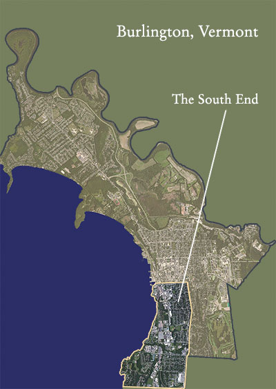
Burlington’s South End is usually delineated as the southern portion of the Queen City. Many of Burlington’s residents might describe the physical region of the South End almost linearly, as a neighborhood running along Pine Street, and parallel to the waterfront. Yet, the South End extends beyond that. It includes the shoreline and natural areas to the west of Pine Street and the industrial and residential neighborhoods to the east. Officially, the northern boundary of the South End is Maple Street. Its eastern bounds are South Union Street and Shelburne Road. And its southern limit is then the city line found at Queen City Park Road.
Historically, this section of town was the primary site of much of Burlington’s rich industrial history. It was firstly a railroad corridor and the location of many mills and factories. The shoreline we now know was reshaped, via landfill, brought in to facilitate the lumberyards and commerce at lake’s edge. Neighborhoods subsequently emerged nearby the waterfront to house the blue-collar workers of the late 1800’s and early 1900’s. Some of these once ‘worker housing’ neighborhoods are now amongst Burlington’s most sought after addresses. This industrial legacy has also inadvertently set the stage for a long-percolating South End small business and artisanal renaissance, especially along Pine Street. Many of the old industrial structures have been renovated to serve as manufacturing and business spaces, and, most recently, an increasingly tangible colony of artists’ studios and performance spaces have blossomed, here, making the South End an increasingly vibrant Burlington hub.
Much of the South End is indeed now zoned by the city as an “enterprise district” — or, an area zoned, via tax incentives and alternate development regulations, to stimulate growth and foster economic and artistic innovation. Unofficially paralleling the Intervale’s agrarian incubator exercise, some of the South End seems to be a cultural mentoring and small businesses, makers and arts experimentation zone.
The waterfront is the other undeniably charismatic feature of Burlington’s South End. Publicly accessible natural areas, such as Oakledge Park and the waterfront defining, lake-paralleling bike path play a significant part in the identity and experience of this section of the city. The Barge Canal, originally* a commercial hub for loading and offloading manufacturing supplies and lumber, has become another widely discussed feature, with its notorious legacy of industrial pollution and controversial pollution remediation approaches. The current day Barge Canal has become a thriving wetland ecosystem and a re-wilding space. Interestingly, just south of it, and at what once was the Webb family estate before they assembled and decamped to Shelburne Farms, Oakledge Park now offers a popular urban destination, combining access to a public beach, wooded groves, open fields, picnic areas, and childrens’ playgrounds, even while hosting diverse animal and plant communities, as well.
Since the late 1800’s, the geography of the South End has largely been shaped by human presence and industry, and yet almost equally so by its intrinsic, resurgent biotic vibrancy as well as by a legacy of unintended largess and a burgeoning, communitarian neighborhood ethos. Today, its daily life varies dramatically from its doings centuries ago. At present, and with all this in mind, community members and city planners are consciously — perhaps even conscientiously? — working toward defining and refining common aspirations aimed at helping this area thrive.