Focal Places in Burlington
The South End: Barge Canal
Burlington’s Barge Canal is a notable and possibly notorious waterfront locale in the city’s south end. Along the lake’s edge, the Barge Canal site includes acres of a wetland ecosystem surrounding the canal basin. The basin, constructed in 1869, was designed to facilitate the transport of lumber from all over the northeast. With growth of industry and technology, Burlington's need arose for a coal gasification plant in the early 1900’s.
In 1908, a coal gasification plant began its operation on Pine Street. Coal gas was historically used for municipal lighting and heating before the advent of industrial-scale production of natural gas. Records show that the operation on Pine Street supplied the “water gas” which fueled the Burlington Gas Light Company. The plant continued its operations well into the 20th century, serving the city of Burlington, until 1966.
 During this fuel production process, plant wastewater, residual oil, and other discharge were disposed of in the adjacent wetland. Compounds associated with coal tar were discovered as the state identified materials seeping from the wetland into the canal watershed.
The response from the Environmental Protection Agency (EPA) began in 1983 when the area, now considered a Superfund site, was first put on the National Priorities List by the EPA. The EPA then proposed a solution to dig up the waste and pile it in a 25 foot high landfill, thus creating one of Burlington’s largest structures. Local residents and organizations, however, did not agree with their high cost, high impact proposal. Led by the Lake Champlain Committee, community members and organizations proposed an alternative solution that would involve less disturbance to the local wetland ecosystem.
The new response plan began with the following emergency action:
“In 1985, the EPA excavated 500 cubic yards of coal tar, solidified it, and disposed of it in an approved facility. The Maltex Pond area also was capped with clay and covered with topsoil and seeded. A temporary fence was erected, warning signs were posted, and sampling was conducted” (2014, EPA).
Though to passersby, the fenced in wetland with its “keep out” signs may look abandoned, it is far from forgotten. Following the 1985 EPA response, long-term studies and careful remediation have been taking place ever since. Research on the designated brown field has revealed that the cap was not entirely preventing seepage. 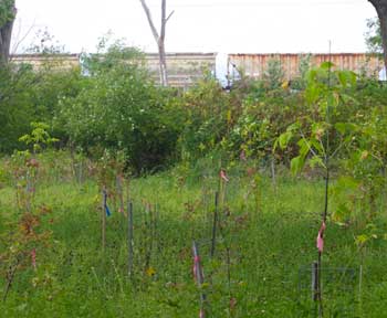 An ongoing release of coal tar was discovered in some areas. Therefore, in 2009, parts of the protective sand cap were then replaced by new protective materials designed to absorb and sequester contaminants When this new cap is filled, it will be removed and replaced. In 2011, another amendment was made to the site as a response to growing concentrations of contaminants in the groundwater. New barriers were constructed to reduce movement of groundwater and coal tar.
While this site has a long history of hazardous waste and ecological disturbance, its sordid history protects it from any chance of future development. Today, behind the prohibitive fences and “No Trespassing” signs exists a highly protected and monitored re-wilding landscape. A diverse ecosystem of early succession plants grows in the sandy surficial layer. A young forest of recently planted box elder saplings towers just above the tall grasses east of the canal basin. North and south of the small plantation are the lofty canopies of wooded areas. Along the shore, sprouting from beneath the protective cap are thick swaths of phragmites. A beaver family has a lodge just out of plain view. Birds and insects flit about the air. While the rest of the south end is largely comprised of pavement, production, and people, this 38 acre natural area nestled along the lake shore provides a habitat for many species of flora and fauna.
More details on the clean-up response can be found at the EPA website.
- Vermont Public Service Board. (1912). The Thirtheenth Biennial Report of the Public Service Commission of the State of Vermont. Bellows Falls, VT: The P.H. Gobie Press
- Coal gasification. (2014). In Wikipedia. Retrieved from http://en.wikipedia.org/wiki/Coal_gasification
- U.S. Environmental Protection Agency. (2014). Waste Site Cleanup & Reuse in New England: Pine Street Canal. Retrieved from http://www.epa.gov/region1/superfund/sites/pinestreet
- Bellinger, N. (2003, April 15). Barge Canal. Lake Champlain Basin Program. Retrieved from http://www.lcbp.org/Champlain2000/c2k/bargecanal.htm
- Balizchuk, N. (1993, February 7). Superfund: The Road to Nowhere : A Five-Part Investigative Series – Day 1: Drowning in Bureaucracy. Burlington Free Press. Retrieved from http://www.nasw.org/users/nbazilchuk/Articles/bcday1.htm