The Challenge
When it comes to Vermont’s electric grid, we face a dilemma: How can we meet our growing needs for reliable electric power at a time when increasingly powerful weather events threaten the reliability of our electric system like never before?
As Vermont turns to electric vehicles to move us and electric heat pumps to keep us comfortable, we become more reliant on uninterrupted electric service.
At the same time, strong winds, flooding rains, ice storms, and heavy, wet snow are increasingly wreaking havoc on the grid.
Electric utilities conduct preventative maintenance to try to stay ahead of that damage. Problem trees are removed, and weakened lines and poles are repaired. But in a rural, mountainous, heavily forested state, staying ahead of the potential damage is difficult. There are too many miles of lines to monitor directly, and existing methods to identify risks throughout the system are incomplete.
Electric grid operators need a way to more accurately predict at-risk areas of the system so that they can more effectively target repairs and updates.
The Proposed Solution
“When we have this system set up to model any network in Vermont, we’ll be able to predict the risk and impact of these outages, so that the next time a huge storm passes through Vermont, hopefully your lights will stay on.” - Alby Penny, UVM's CREATE team
A partnership of state officials, electric industry operators, and University of Vermont researchers are working to meet that need with System Optimization and LiDAR for Vermont Energy Resilience, or “SOLVER.”
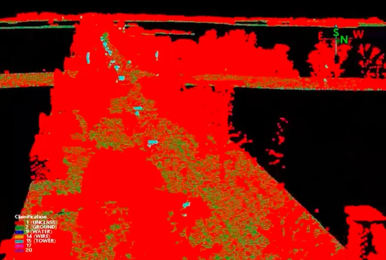
Using LiDAR data provided by the Vermont Center for Geographic Information (VCGI), UVM’s Spatial Analysis Lab (SAL) is able to create detailed 3D maps of Vermont’s electric grid. These maps offer electric utilities a much more comprehensive way to spot damaged infrastructure or find trees that might threaten the power lines in a storm.
Researchers at UVM's CREATE team (Center for Resilient Energy Autonomous Technologies in Engineering) are then able to feed that information into computer models to simulate activity across Vermont's electric grid. This allows them to rank those vulnerable areas and determine which pose greater threats to grid operations during a storm.
This information will allow utilities to more strategically prioritize their preventative maintenance efforts. This in turn has the potential to save millions of dollars, improve grid resiliency, and help pave the way for the state to meet its goal of obtaining 90% of its energy needs from renewable sources by 2050.
Project Details
| Community Partners: | Vermont Electric Power Company (VELCO) Burlington Electric Department Washington Electric Cooperative |
| UVM Partners: | |
| Amount: | $269,482 (Partnership Grant) |
| Primary Region: | Statewide. Rural pilot areas to be identified during project period. |
| Focus Areas: | Resilient Energy Systems |