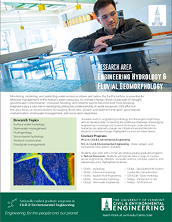
Overview
CEE faculty and student research in engineering hydrology and fluvial geomorphology address key needs in hydrogeology, groundwater hydrology, surface water hydrology, stormwater management, and wetland & floodplain conservation.
Highlighted Research Projects & Initiatives
Agricultural Water Quality Management
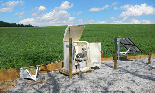 Water quality degradation from agricultural field runoff that contains excess nutrients is a pressing environmental challenge in Vermont and throughout the world. CEE researchers and collaborators study multiple treatment technologies employed at both the farmstead/production and edge of field areas. Working with UVM Extension and many other partners, we are designing and testing of novel denitrifying bioreactors, evaluating effect of best management practices (BMPs) on surface and subsurface water and nutrient fluxes, designing and testing phosphorus removal technologies, monitoring and modeling watershed hydrology and nutrient export from agricultural watersheds in the Lake Champlain Basin, and studying the effects of climate change on agricultural fields.
CEE Faculty: Joshua Faulkner, Eric Roy
UVM Collaborators: Stephanie Hurley, Carol Adair, Don Ross (Emeritus), Kristen Workman, Heather Darby, Jeff Sanders
Collaborating Institutions & Organizations: USDA-NRCS, Soil Health Institute, Newtrient LLC, USDA-ARS, Vermont Agency of Agriculture, Food & Markets
Multi-Objective Optimization to Examine Tradeoffs in River Reconnection Projects
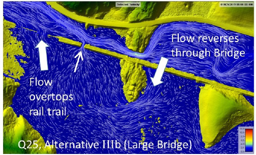 Floodplain and river reconnection projects show great promise to restore water quality, improve flood resilience and enhance habitats. However, with the exponential availability of environmental sensors and associated information, resource managers and planners need decision-support tools to help identify the more effective locations and techniques for floodplain reconnection. Our team is developing multi-objective optimization algorithms to assess multiple stakeholder criteria that prioritize suites of restoration or conservation projects at river network and basin scales. These algorithms may be wrapped around existing hydraulic models (2D HEC-RAS, HAND) or databases (VTANR stream geomorphic data sets) to evolve solutions that optimally meet flood resiliency and water quality goals while simultaneously addressing stakeholder needs. This research is being advanced under several projects supported by the VT Agency of Transportation, VT Department of Environmental Conservation, Lake Champlain Sea Grant, Lake Champlain Basin Program, and the VT Water Resources & Lake Studies Center.
CEE Faculty: Kristen Underwood, Donna Rizzo, Mandar Dewoolkar
UVM Collaborators: Rebecca Diehl, Beverley Wemple
Collaborating Institutions & Organizations: Vermont Agency of Transportation, Vermont Agency of Natural Resources, Vermont Land Trust, The Nature Conservancy of Vermont, Gund Institute for Environment
Functioning Floodplain Assessment, Mapping, Valuation, and Tracking to Support Floodplain Restoration and Protection in the Lake Champlain Basin
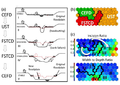 River reconnection projects provide water quality protection and improvement, enhanced fish and wildlife habitats, avoided damage from floods and streambank erosion, storage of phosphorus, carbon and other nutrients. Vermont has embarked on a Functioning Floodplain Initiative to quantify the extent of lateral and longitudinal disconnection of our rivers , and to identify opportunities for strategic reconnection. Researchers in river science and machine learning are combining efforts to inform the selection of floodplain, wetland and river restoration projects in the Lake Champlain basin. The availability of state-wide stream geomorphic data allows us to better understand the influence of channel-floodplain coupling on fine sediment sourcing and storage dynamics. Field and laboratory efforts are measuring fluxes of particulate and dissolved phosphorus to and from floodplains and riparian wetlands. This project is supported by VT Department of Environmental Conservation, Lake Champlain Sea Grant, and the Lake Champlain Basin Program.
CEE Faculty: Kristen Underwood, Eric Roy, Donna Rizzo
UVM Collaborators: Beverley Wemple, Rebecca Diehl
Collaborating Institutions & Organizations: SLR International, Fluvial Matters, Fitzgerald Environmental Associates, Stone Environmental, Vermont Agency of Transportation, Vermont Agency of Natural Resources, Vermont Land Trust, The Nature Conservancy of Vermont, Gund Institute for Environment