An Introduction to the Vermont Monitoring Cooperative
Established in 1990 as a partnership among the USDA Forest Service, the State of Vermont Agency of Natural Resources and The University of Vermont (UVM), the mission of the Vermont Monitoring Cooperative (VMC) mirrors and builds upon the priorities of these partners. The VMC serves as a hub to facilitate collaboration among federal, state, non-profit, professional and academic institutions towards ongoing monitoring of forested ecosystems across the region and an improved understanding of forested ecosystems in light of the many threats they face.
The VMC is unique in its relatively small staff who function to support and facilitate the activities of a much larger network of actively engaged collaborators. While VMC funding primarily supports ongoing research, monitoring, outreach and data management, the bulk of VMC activities are accomplished by “in kind” contributions provided by the larger collaborative network. Over 60 professionals actively contribute to current and ongoing monitoring and research projects, and more than a hundred other contributors have bolstered the monitoring record through their work in years past. Beyond these direct contributions, the Cooperative encompasses many more individual environmental researchers, land managers, decision makers, environmental advocates, educators, industry professionals and faculty from over 20 organizations across Vermont, New Hampshire, Massachusetts and New York. This committed group of active collaborators synthesize and utilize this information based on a shared interest in the health and management of forested ecosystems across the region.
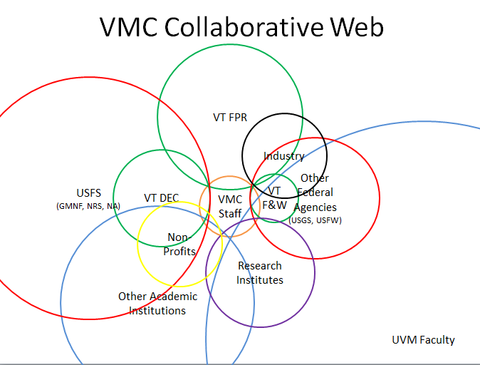 Figure 1. The collaborative interrelationships among VMC's many cooperators and stakeholders.
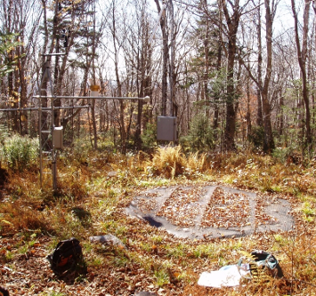 Figure 2. VMC Soil Climate Analysis Network site at Lye Brook Wilderness Area in Manchester, VT.
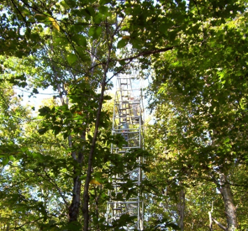 Figure 3. VMC forest canopy tower at the Proctor Maple Research Center in Underhill, VT.
Over the 25 year history of the VMC, its core priorities have remained closely aligned with its founding partners: to provide the information necessary to conserve and manage forested landscapes, identify and monitor threats to forest health and function, and to facilitate collaboration among a diverse group of stakeholders. To this end, the VMC has collected and maintained one of the longest and most expansive records of forest health, wildlife, soil, air and water quality data in the region. Made discoverable and downloadable via VMC's online database, this information has been critical to resource managers, researchers and policy makers across the region.
Originally these VMC monitoring and research efforts were focused at two intensive sites: Lye Brook Wilderness Area on the Green Mountain National Forest in southern Vermont (Figure 4), and State-owned lands located on the slopes of Mt. Mansfield within the Browns River, Stevensville Brook and Ranch Brook watersheds (Figure 5). Focusing efforts on these intensive sites provided the capability to co-locate studies to better understand ecosystem processes and impacts across biotic and abiotic strata. Considering the lack of Vermont's representation in other long-term ecological networks (e.g. Long Term Ecological Research Network, National Ecological Observatory Network, experimental forests), and the demonstrated sensitivity of these ecosystems (Vogelmann, 1982; DeHayes et al., 1991; DeHayes et al., 1999, Schaberg et al., 2000) these intensive sites filled a critical gap in environmental monitoring efforts.
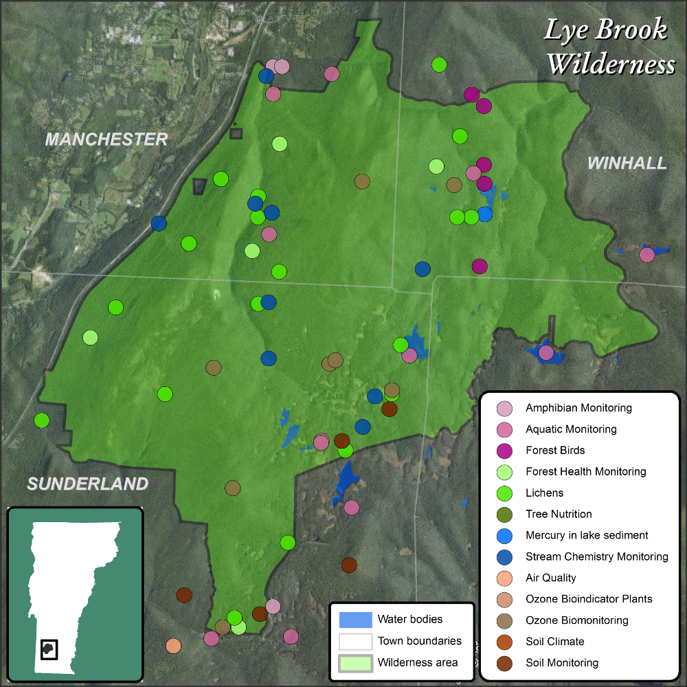 Figure 4. Relative location, boundary, and monitoring and research plot locations at the VMC Lye Brook Wilderness Area intensive site in southern Vermont
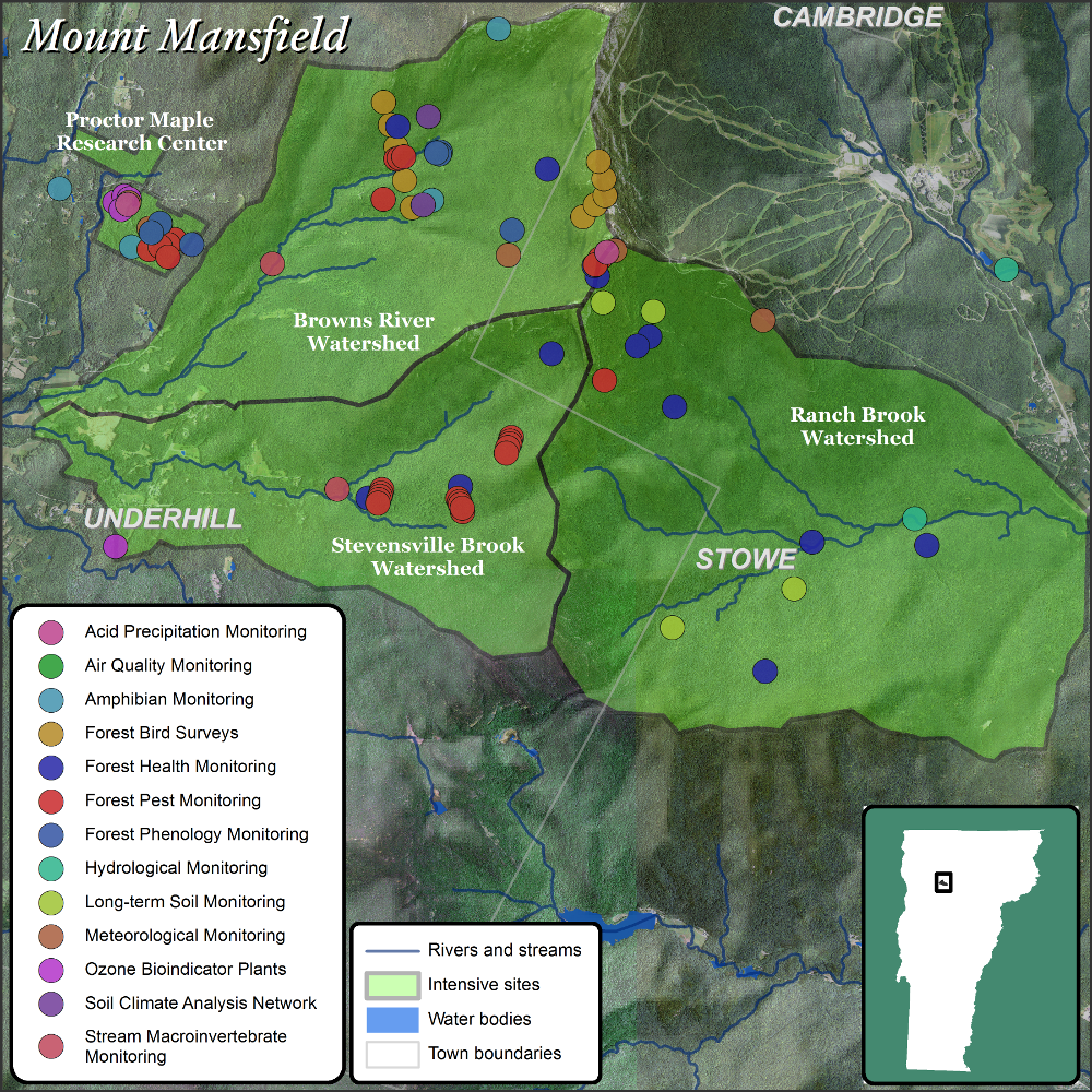 Figure 5. Relative location, watershed boundaries, and monitoring and research plot locations at the VMC Mt. Mansfield intensive site in northern Vermont.
Over the past decade, VMC efforts have expanded beyond these intensive research sites, in part by design to improve our understanding of a diversity of habitat types, but also because of the widening network of collaborators working across the region. The VMC database now contains data from across the state, as well as state and region-wide geospatial data layers relative to forest ecosystem health (i.e. statewide aerial sketch mapping of defoliation, mortality, or other symptoms). The wide range of high priority, long-term monitoring efforts, sustained or supported by the VMC collaborative is shown in Table 1. While many of these datasets are maintained directly with VMC financial and technical support, additional datasets (denoted by *) are collected by VMC collaborators, with the VMC fulfilling the role of data archiving, synthesis and distribution.
| Forest Health |
|
| Spatial Forest Products |
|
| Climate |
|
| Pollution |
|
| Soil |
|
| Water |
|
| Wildlife |
|
While the core group of VMC collaborators are scientists and researchers actively involved in VMC related projects, the network is primarily composed of land managers and decision makers from a range of public agencies. Through their efforts, the findings of the VMC collaborative are regularly communicated to policy makers, practitioners and the general public. VMC information assists partners at the local, state and regional levels in managing the ecological aspects of the forested landscapes while considering the social dimensions represented by the people who live, work and play in those same forests. With the growing interest in quantifying, preserving and enhancing the ecosystem services provided by the region's forested landscapes, there is a need to understand how human activity relies upon and impacts those services. Long-term ecosystem monitoring provided by the VMC generates the data that will be needed to quantify those services, as well as to detect changes or signs of potential degradation from both social and environmental stressors.
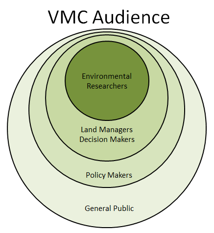 Figure 6. VMC's core of cooperators and scientists who provide data and information to land managers and decision makers, policy makers and the public.
As a collective group, the VMC provides the connection between data, researchers, managers and practitioners to compile a more comprehensive assessment of the region's forests. While individuals come and go through positions, and funding is often unstable, the VMC has provided a continuous source of environmental monitoring, from trees to water, air, soils and wildlife, leading to a more complete assessment of environmental conditions, long-term analyses of trends and integration across datasets. This tremendous accumulation of environmental monitoring records places VMC at a crossroad, where synthesis and integration of long-term datasets provide unique opportunities to understand how changing social and environmental factors have affected, and will continue to affect the structure and function of the region's forests. In this way the VMC has provided integral information to sustain forest health and the many benefits healthy forested ecosystems provide.