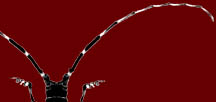
Asian
Longhorned Beetle
|
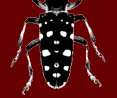
Asian
Longhorned Beetle
|
 |
|
Infestations
|
|||||
Infestations
A
quarantine is a legal measure taken by a state or federal agency to
prohibit the spread of a pest from one area to another. Quarantine zones change with new discoveries of ALB. To view any new developments, please click HERE for the Official USDA Asian Longhorned Beetle Website. If you live or work in a quarantine zone, be aware that special guidelines have been developed for handling wood and planting trees in these zones. You must follow these guidelines:
ALB has been declared eradicated in several areas as a result of established quarantines! For example: Chicago, IL - 2008 Islip, New York - 2011 New Jersey - 2013 Canada - 2013 Manhattan and Staten Island, New York - 2013 Below are some historical maps of the quarantine areas that were established for Carteret and Jersey City in New Jersey, Brooklyn, Queens and Manhattan, Amityville, and Islip in New York, Chicago, Illinois and Toronto, Ontario in Canada. |
|
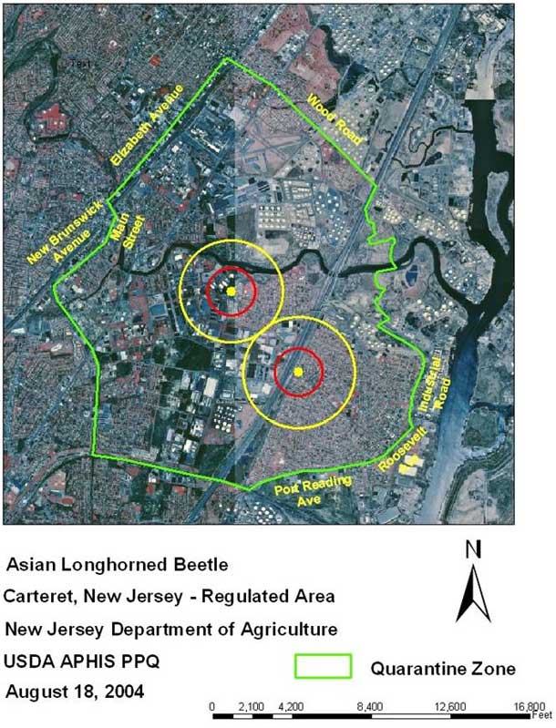
New Jersey Infestations (as of 2005) Carteret and Jersey City |
Infestations have been found in
the Carteret, New Jersey area. The USDA and the New Jersey Department of Agriculture are currently removing more than 4,000 trees from the Middlesex/Union ALB infestation site, discovered earlier in the fall of 2004 and plan to remove an additional 1,400 trees within the city of Rahway. The additional trees in Rahway need to be removed as a result of a discovery of an infestation there found during subsequent surveys. Research has shown that host trees, trees the ALB likes to attack, within a 1/4 mile radius of an infested site are likely to be found later infested by the ALB if left standing. It is for this reason that high risk exposed host trees need to be removed. Map of Carteret compared to surrounding areas. For an aerial map, click here. |
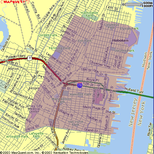
Jersey
City Infestations
 The beetle was first spotted in Jersey City in October of 2002 by someone who saw it fly onto a tree. A later news report attracted his attention to the potential threat of the Asian longhorned beetle. He contacted the NJDA, and state and federal agricultural inspectors confirmed the beetle's presence soon after. Based on an initial survey, it appears that approximately 100 trees were affected within a 9-acre area just north of the Newport Parkway and just east of Washington Boulevard. A quarantine has been established in New Jersey. The quarantine boundary begins by the Hudson River to the east, 11th Street in Hoboken to the north, Summit Avenue in Jersey City to the west and Grand Street to the south. For a map of the quarantined area click here. |
||
|
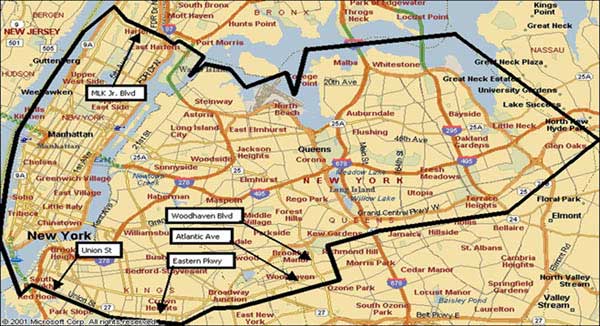
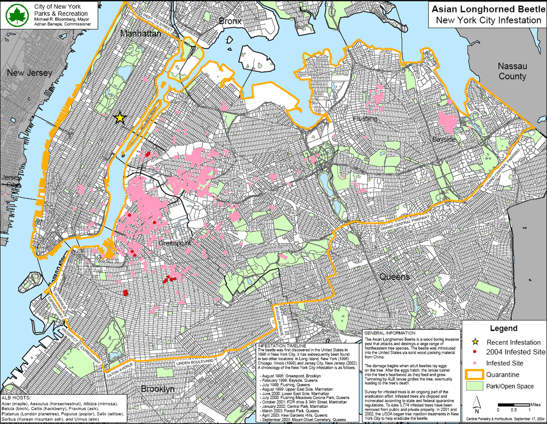
New York Infestations (as of 2005) Brooklyn, Queens, and Manhattan |
|
The Manhattan infestation was discovered in August of 1999 at a private playground where 30 trees were eventually removed as part of the eradication effort. Several small pockets of infestation were discovered in the lower east side of Manhattan during the spring and the summer of 2000 leading to the removal of 52 additional trees. This infestation forced removal of a tree shading the grave of Peter Stuyvesant (1610-1672) at the historic St. Mark's-in-the-Bouwerie Church. Stuyvesant was the last Dutch director-general of New Netherland before surrender to the English in 1664. The Queens infestation was discovered in the summer of 2000 and forced the removal of 24 trees including a number of trees at the Flushing Zoo. This infestation will eventually connect the Manhattan and Bayside quarantine zones. Areas of Brooklyn, Queens, and Manhattan in the City of New York and bounded by a line beginning where the Brooklyn Battery Tunnel intersects the Manhattan shoreline of the East River, west and north along the shoreline of the Hudson River to Martin Luther King Jr. Blvd., east along Martin Luther King Jr. Blvd. and across the Triborough Bridge to the west shoreline of Randall’s and Ward’s Island, east and south along the shoreline of Randall’s and Ward Island to the Triborough Bridge, east along the Triborough Bridge to the Queens shoreline, north and east along the Queens shoreline to New York City and Nassau Co. line, southeast along this line to Grand Central Parkway, west along the Grand Central Parkway to Jackie Robinson Parkway, west along the Jackie Robinson Parkway to Woodhaven Blvd., south along Woodhaven Blvd., to Atlantic Ave., west along Atlantic Ave. to Eastern Parkway Ext., south and west along the Eastern Parkway Ext. and Eastern Parkway to Grand Army Plaza, west along the south side of Grand Army Plaza to Union St., west along Union St. to Van Brunt St., south along Van Brunt St. to Hamilton Ave. and the Brooklyn Battery Tunnel, north along Hamilton Ave. and the Brooklyn Battery Tunnel to the East River, north along the Brooklyn Battery Tunnel across the East River to the point of beginning. |
| Amityville |

Areas in Amityville, West Amityville, North Amityville, Babylon, West Babylon, Copaigue, Lindenhurst, Massapequa, Massapequa Park, and East Massapequa in Oyster Bay and Bablylon; in Nassau and Suffolk Co. and bounded by a line beginning where West Main St. intersects the west shoreline of Carlis Creek, west along West Main St. to Rte. 109, north along Rte. 109 to Arnold Ave., northwest along Arnold Ave to Albin Ave., west along Albin Ave to East John St., west along East John St. to Wellwood Ave., then north along Wellwood Ave to Southern State Parkway, then west along the Southern State Parkway to Broadway, south along Broadway to Hicksville Road, continuing south along Hicksville Road to Division Ave., and south along Division Ave. to South Oyster Bay, east along the shoreline to Carlis Creek, then along the west shoreline of Carlis Creek to the point of beginning.
|
| Islip Infestation |
Areas of Bayshore, East Lslip, and Islip Terrace
in Islip, Suffolk Co. and bounded by a line beginning where Rte. 27A
intersects Brentwood Road, east along Rte. 27A to Southern State
Parkway Heckscher Spur, north and west along the Southern State Parkway
Heckscher Spur to Carleton Ave., north along Carleton Ave. to the
southern boundary of the New York Institute of Technology, then west
along the southern boundary of the Institute through Wilson Blvd. to
Pear St., west along Pear St. through Freeman Ave. to Riddle St., west
along Riddle St. to Broadway, south along Broadway to the Southern
State Parkway Heckscher Spur, west along Southern State Parkway
Heckscher Spur to Brentwood Road, south along Brentwood Road to the
point of beginning. To see larger map of all infested areas within the New York Metro area, click here. |
Infestations in Chicago, Illinois (as of 2005) |
Click here to view a quarantine map for Chicago |
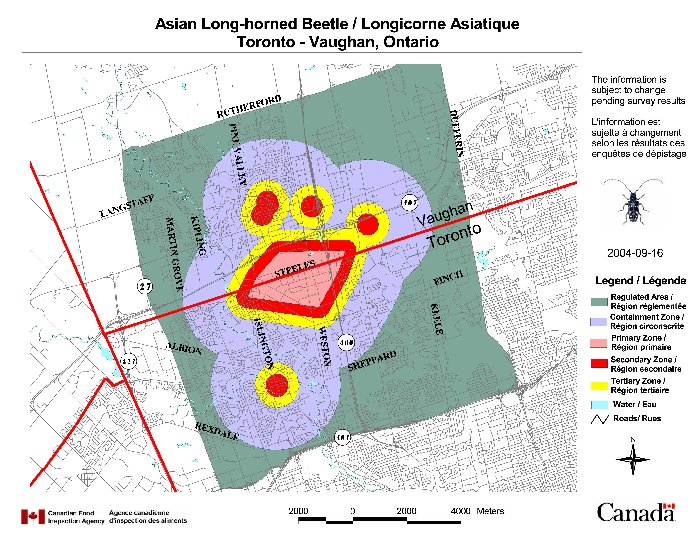
Infestations in Canada (as of 2005) |
|
| Click here
to view
a larger view. Click here to view a closer view. (in PDF) |
 |
