During the early part of the 20th century Louis L. McAllister documented many public works projects in the city of Burlington, VT. Many of the photographs of this area focus on two paving projects, one in 1929 when the the brick paving was covered by asphalt, and then again in the 1943 when the old streetcar rails were removed.
In the graduate class, Researching Historic Sites/Structures, we compared the McAllister photos to images we took today. Many of the buildings in my area still stand today, and are either used for a similar function or have been adapted to new uses. The ones that have been lost are mostly because of fire.
-Sara Casten
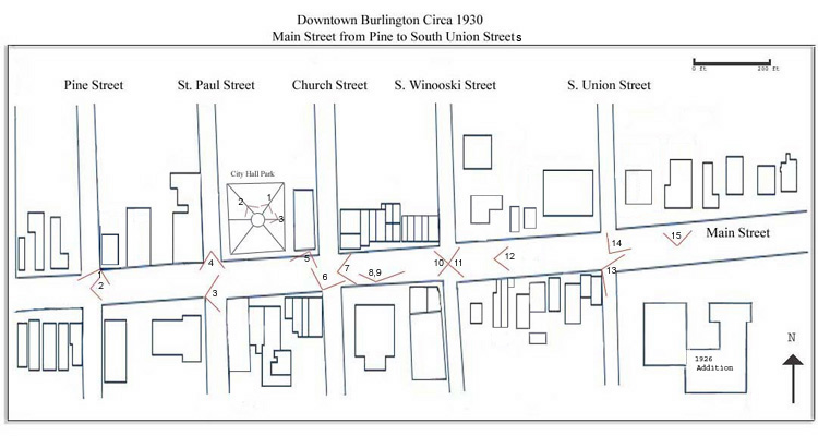
To access photo comparisons click on the numbers on the above map or on the list to the right.
Return to Burlington, Vermont: South of Pearl Street and Colchester Avenue |
Main Street: from Pine to South Union Streets
1. Corner of Main and Pine Streets
2. Intersection of Main and Pine Streets
3. Corner of Main and St. Paul Streets
4. Intersection of Main and St. Paul Streets
5. City Hall, from the First Story Window
6. Corner of Main and Church Streets
7. Intersection of Main and Church Streets
8. In Front of the Post Office--Facing Northwest
9. In Front of the Post Office--Facing Northeast
10. Intersection of Main and S. Winooski Streets--Facing West
11. Intersection of Main and S. Winooski Streets--Facing East
12. Main Street up a bit from #11
13. Corner of Main and S. Union Streets
14. Intersection of Main and S. Union Streets
15. Main Street up a bit from #14
City Hall Park
1. City Hall Park--Facing Main Street
2. City Hall Park--Facing City Hall
3. City Hall Park--Facing St. Paul Street
|