
trend is
flat
over time
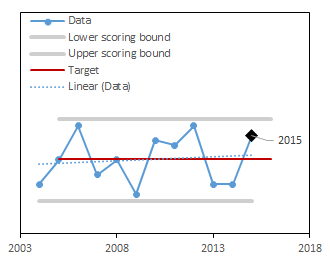
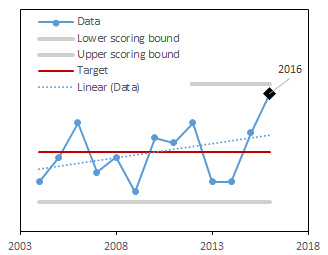
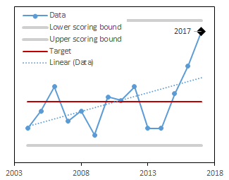
Forest cover is the percent of the state of Vermont with tree cover.

trend is
down
over time
Regeneration of sugar maple seedlings provides information about the future of Vermont's hardwood forests.
trend is
flat
over time
Regeneration of red spruce seedlings provides information about the future of Vermont's softwood forests.

trend is
up
over time
Forests with greater stand complexity have trees in a range of sizes and as a result, may be more productive and resilient to stress.
trend is
flat
over time
Forest patch sizes provides information on the average size of contiguous forest blocks.
trend is
flat
over time
Forest connectivity is a measure of the linkages among Vermont's forests.
trend is
down
over time
With greater diversity in tree species, forests can support more biodiversity, exhibit higher resilience to stress, and store more carbon.
trend is
down
over time
Across the landscape, having a range of forest stand ages provides diversity, varied habitat conditions, and resilience to stressors.
Latest Score:
3.5/5
in 2024
score trend is flat over time
Forest cover is a measure of how much total forest exists in Vermont. The Vermont forested landscape has experienced drastic changes over its history, from widespread land-clearing to subsequent reforestation. In recent years, however, forest cover has been in decline due to development pressures. Declining forest cover means that there are reductions in timber resources, wildlife habitat and food sources, and ecosystem services such as air quality mitigation, recreational opportunities, and carbon storage. Here, forest cover is measured as a percent of the state with tree cover. A high score means that the amount of total forest cover is remaining stable over time
Increasing for a long time and now decreasing again, this time due to urbanization rather than agricultural expansion. Urbanization represents a more permanent land cover change than agriculture, and is accompanied by a larger set of demands from and impacts on the surrounding forest.
Rachel Rienmann, Research Forester/Geographer; USDA U.S. Forest Service Northern Research Station
The score is calculated using a target value and the historical range of the the entire long-term dataset. The higher the score, the closer this year's value is to the target.
Once the score is computed for each year, the trend in scores over time is calculated. If the trend is significantly positive or negative, the long-term trend is marked as increasing or decreasing respectively.
| Component | Description |
|---|---|
| Scored as | Deviation from the target (scaled between 1 and 5) |
| Target value | Long-term mean |
| Directionality of scores | No change from the long-term mean is better |
| Minimum value used in scoring | Data minimum - 10% of the range |
| Maximum value used in scoring | Data maximum + 10% of the range |
We used forest cover estimates generated by the USFS Forest Inventory and Analysis Program EVALIDator1 (“0079 Area of sampled land and water, in acres”). We relied on the query and methods set by FIA to compute these estimates (Accessible forest as defined by FIA)/(Total land– (Noncensus Water + Census Water)) x 100%). We then converted them to a percentage of the state of Vermont using the total area of the state. The target was set as the long-term mean value. The current year is scored for where it falls between the target and the upper scoring bounds (maximum value in the dataset +10% of the range) or the lower scoring bounds (minimum value in the dataset -10% of the range), scaled to be between 1 and 5.
Dataset: Northeast Forest Cover