
trend is
flat
over time
The average crown dieback of trees in Vermont's forest provides us information on overall forest health.
trend is
flat
over time
Damages to forests occur from insects, diseases, weather events, animals, and human impacts.

trend is
up
over time
Forest growth provides information on how much biomass Vermont's trees add annually.
trend is
flat
over time
Higher values of canopy density indicate a more lush, green, and productive forest.
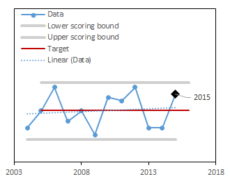
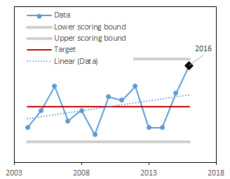
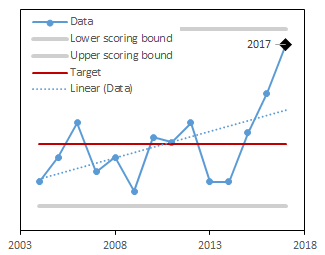
trend is
flat
over time
Mapped forest mortality is an assessment of the total area of current-year tree mortality across the landscape.
trend is
flat
over time
The proportion of trees with damage and decay provides information on the condition and the potential timber quality of Vermont's trees.
trend is
flat
over time
Individual tree mortality is a natural and common event, but changes to the baseline rate can signify worsening environmental conditions for trees.
Latest Score:
4.8/5
in 2024
score trend is flat over time
Forest damage is assessed by a visual inspection of forest damage via fixed-wing aircraft and reported in the Insect and Disease Surveys (IDS). IDS are conducted annually by the State of Vermont and the USDA Forest Service to map forest disturbance, including damage caused by insects, diseases, fire, weather events, or a range of other causes1. Although mortality is a natural occurrence within forests, widespread die-offs are indicative of stressors that may lead to diminished ecological function and ecosystem resilience. This metric is computed as the total area mapped with visible mortality that has occurred since the previous survey. A high score means that forest mortality is remaining low over time.
Aerial detection surveys (ADS) are conducted annually by the Vermont Division of Forestry and USDA Forest Service to document the extent and severity of forest disturbance caused by insects, disease and abiotic factors throughout the state. These data offer a comprehensive assessment of the condition of forests across the landscape. Here, we quantify the total area mapped as mortality. The current year is scored as the difference between the minimum -10% of the range and maximum +10% of the range.
Josh Halman, Forest Health Specialist; Vermont Department of Forests, Parks and Recreation
The score is calculated using a target value and the historical range of the the entire long-term dataset. The higher the score, the closer this year's value is to the target.
Once the score is computed for each year, the trend in scores over time is calculated. If the trend is significantly positive or negative, the long-term trend is marked as increasing or decreasing respectively.
| Component | Description |
|---|---|
| Scored as | Distance between minimum (-10%) and maximum (+10%) (scaled 1-5) |
| Target value | Data minimum |
| Directionality of scores | Lower values in the data are better |
| Minimum value used in scoring | Data minimum - 10% of the range |
| Maximum value used in scoring | Data maximum + 10% of the range |
Insect and Disease Surveys (IDS) are annual aerial surveys of forests conducted by the state of Vermont and the USDA Forest Service to map areas of tree mortality1. While the program has been conducted for many decades in Vermont, the first year of digitally available data is 1995. This metric is computed as a sum of total area mapped with visible mortality in a given year that has occurred since the previous survey. We set the target for this dataset to be lowest possible acreage (either the minimum value in the data minus 10% of range or 0, whichever was greater). The current year is scored as the difference between the target and the upper scoring bounds (maximum value in the dataset plus 10% of the range), scaled to be between 1 and 5.