Overview
.jpg)
Known as the Queen City, Burlington is Vermont’s largest city. Indeed it is the largest US city in northern New England and Champlain Valley region. Serving as a hub for commerce, transportation and higher education; this city built on a hill and westerly slope down to the shores of Lake Champlain demonstrates through its densely packed neighborhoods of mixed old and new buildings, its own transition of a small agrarian village to a thriving industrious city of the late 19th century to diverse and desirable city of the 20th century.
An effective way of tracking this transition is through individual city block analysis. Aided by various sources such as historic maps, city directories, newspapers, and old photographs to name a few, one can trace a building or property plot backwards through time discovering who lived or worked on a site, what stood on a site, and how the previous two operated within the greater community. Asking these questions and following the evidence provided by the sources illuminates a fascinating and at times heartbreaking history, that never the less provides clues to today’s physical world.
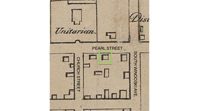
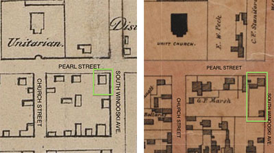
The focus area for this study is the southerly side of Pearl Street between Church Street and South Winooski Avenue. By the nature of city blocks , the corner lots always extends around to the adjoining street thus parts of Church Street and South Winooski Avenue are included within this study. The modern physical addresses going west to east are: 2 Church St, 163 Pearl St., 175-177 Pearl St., 185 Pearl St., 187 Pearl St., & 191 Pearl Street. Though one can easily find the properties discussed in this study with a simple Google search, it is important to note the fluidity of addresses through the passage of time. For example, lets follow the Sanborn Maps Company’s listing of 185 Pearl Street. In 1885, the property lists as 185 Pearl Street.1 A map produced in 1900 lists the property as 183 Pearl Street.2 Six years later, the property is listed again as 185 Pearl Street with “183” as its former listing.3 Unless otherwise noted all buildings and properties discussed correspond with current physical addresses. Additionally the order of properties discussed follows the west to east direction aforementioned in the study area.
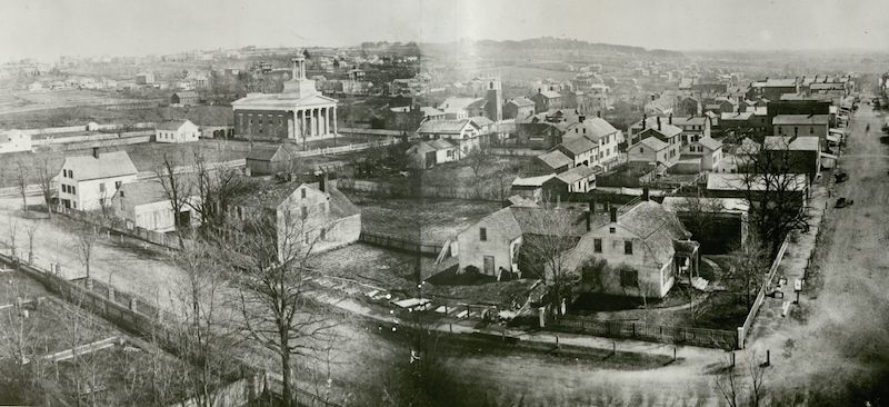
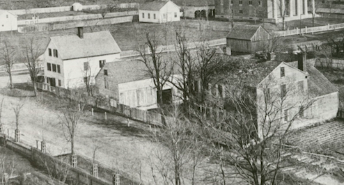
One of the most striking visual sources used in this study is the panorama taken in 1860 from the belfry of the Unitarian Church. Facing southeast, the image below shows the study area with the intersection of Church and Pearl Streets in the bottom right corner.4
2 Church Street & 163 Pearl Street
The earliest evidence of a structure on this site dates from an 1830 map made by architect Ammi B. Young (Figure 3).6 Providing only the footprints of buildings, the map depicts a building, domestic in scale, standing offset from Church and Pearl Streets.
Here stood a westerly facing two-story, five-by-two bay domestic building with gambrel roof and small porch sheltering the main entrance. An addition extends from the back elevation. The entire structure is offset from both Church and Pearl Streets. Included on this property was a standalone brick building seen just beyond the main structure. This property is clearly detailed in the 1860 panorama photograph (Figure 2.)7
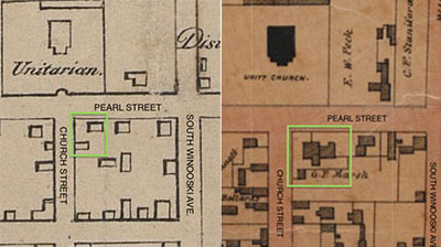
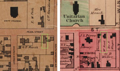
The map produced in 1853 by Presdee & Edwards (Figure 3.) provides a more detailed footprint of both structures seen in the panorama. More importantly it provides the name of the property owner. “G. P. Marsh”.
An outstanding view of George. P. Marsh’s home at the corner of Church and Pearl Street can be seen in the 1860 panorama photograph from the Unitarian Church seen in Figure 2. Note the condition of the house with peeling paint on the north elevation (Pearl Street side), missing shutters on second floor, and new fence construction around property.
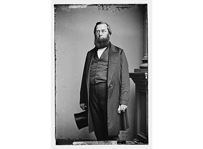
In 1839, Marsh moved his newly married, second wife and son, from a previous marriage, into the home at the corner of Church Street and Pearl Street shown in the panorama. Of note, the standalone fireproof brick structure just to the south of the house served as Marsh’s library housing his 5,000 books and “art portfolios.” This property would serve as a home “base” until Marsh’s appointment as U.S. Minster in 1861.9
George Perkins Marsh was by the time of his death in 1882 considered one of Vermont’s preeminent citizens, whose careers ranged from business, investing, teaching, practicing law and politics. Marsh excelled in academic pursuits becoming fluent in twenty languages, which coupled with his political experience let to his appointment by Abraham Lincoln in 1861, to the position of United States Minister to the United Kingdom of Italy which he served until his death. Most notably Marsh is seen as one of the earliest conservationists in the United States. His seminal work, Man and Nature published in 1864, highlights the notion that humans are changing the environment and the interdependence of all beings within an environment.8
By the end of the 19th century Burlington has undergone dramatic changes. Gone are the days of a sleepy village and empty streets of the 1860’s panorama. Commerce and shipping have expanded Burlington’s population and the demand for valuable land near the commercial core dictates change. Thus, as seen in the 1894 Sanborn Map, buildings along Church Street begins to fill the once open land as progress and commerce marches up the block.10 Within a year, the former home of George P. Marsh would be gone and construction on the Richardson Block would be complete.
The change on this busy street corner is dramatic and swift. Starting in mid-March of 1895 crews begin to excavate for the foundation and basement of the Richardson Block. By mid-July the third story is completed and by early October “artificial stone” sidewalks made of “cement, screened sand and a blue coloring matter” lining the Church and Pearl Street elevations are installed. Three weeks later the Richardson Block opens for business. The quickness of construction is contributed to its use of newer iron frame technology. Built of 150 tons of iron “columns and girders,” the skeletal structure supports carry the building’s load in lieu of costly and time-consuming load bearing masonry.11
.jpg)
.jpg)
The primary façade of this the impressive five-story brick building facing Church Street has the main building entrance and storefronts with large glass display windows. This elevation boasts five towers extending from the second-story to the roofline topped by slate and copper candlesnuffer caps. The secondary façade, facing Pearl Street boasts three towers of same design. The secondary entrance to the building, listed as 163 Pearl Street is located on this elevation.
.jpg)
Being built during in a time in which architects had a cornucopia of styles and influences from which to choose, labeling this building under one architectural style is difficult if not impossible. Though by no means a precise style description, the architect Walter Dickson, described the building as in the “Scoto-French” style.5 Breaking down the architectural elements to individual parts one can see the French influence in the steeply pitched slate-roof reminiscent of a French chateau. The top floor rounded window dormers are more suitable on a Jacobean castle of the British Isles hence the “Scoto” terminology. Regardless, the amalgam of influences results in a well-balanced and impressive commercial building.
The storefront on the ground level operated as a department store for close to ninety years. The store’s name would eventually change to Abernethy’s Department Store and remained so until its closing in 1982. Through that time, the store served as a destination shopping local as well as a social and financial anchor of Church Street.
The commercial stability of the Abernethy’s Department Store led to few minor exterior changes to the exterior of the building. On the iron balconies, gold painted stylized “A’s” replaced stylized “R’s” and the ground level store front was modernized with square brick columns, large, white, horizontal panels spanning the gaps between the columns.12
To maximize interior space, the corner entrance was enclosed by large plate glass display windows and the iron brick column encased in a brick column. Similarly, the upper floors witnessed long-term stability serving initially as apartments then transitioning to small professional offices housing.13 Thus, resulting in very little exterior changes. The storefront and balcony letterings were restored in 1983.14
Located at the rear of the Richardson Block is a parking lot. Since the Richardson’s construction this space has remained devoid of any major structures or developments other than formal gardens and storage structures.15
To the back of the parking lot and standing offset from southern elevation of the Richardson Block is a two-story brick building. Initially a detached structure this building housed the heating boilers and workshop for the Richardson Block.
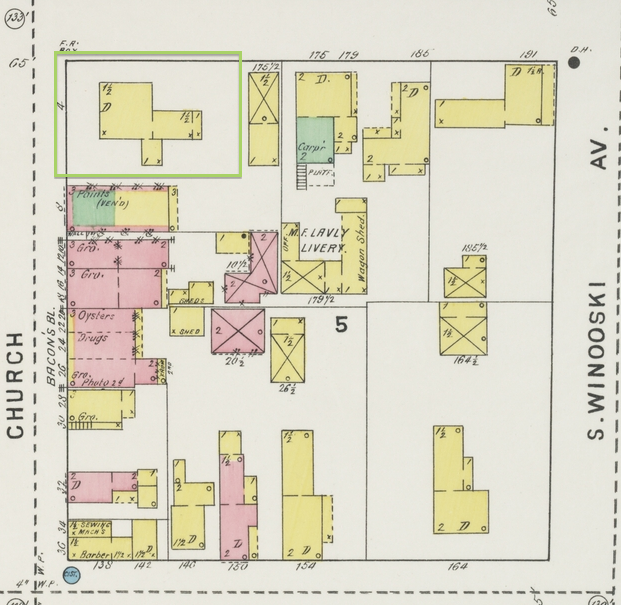
175-179 Pearl Street
.jpg)
Centrally located on the southern side of the Pearl Street block, this two-story, brick-and-stucco building extends back nearly the entire length of the lot. The façade has two glass-storefronts of equal proportions separated by a central doorway leading to the second floor. Additionally the façade and side elevations are clad in brick disrupted by equally spaced brick pilasters. Extending from the architecturally rhythmic façade a disjointed roofline with variations in wall planes speak of multiple additions and renovations through the buildings history.
The current building’s origins are obscure. The earliest evidence of a structure on this site is depicted in Ammi B. Young’s 1830 map of Burlington. Roughly situated in the center of the block a square structure slightly setback from Pearl Street is clearly depicted.16 Presdee & Edwards 1853 map of Burlington shows a similarly setback structure with a new addition opposite the façade.17 A map produced sixteen years later shows a building with a similar footprint as seen in the F.W. Beers map of Burlington.18
400.jpg)
Again the most striking evidence of what stood on this lot can be seen looking closely at the 1860’s panorama photograph (Figure 12.) that was taken from the belfry of the Unitarian Church. Situated roughly in the center of the block is a two-and-a-half story, five-by-three-bay, front-eave, wood-clapboard building with a one-and-a-half-story ell extending south from the rear of the structure.19 Connecting the structure and property lot to what currently exists requires a look into the social history and function of the property.
The earliest known commercial function of this property is listed as “H. Vickery’s Carriage Shop & Spaulding & Russel Paint Shop” as depicted in a map dated to 1862.20 Outbuildings and sheds on property would grow and expand as the local demands the carriage and livery business grew. This is evident when contrasting the Sanborn Maps of 1869 and 1885.21 The property’s close proximity to Burlington’s commercial core allowed for the operation of a carriage shop and livery in one form or another until the arrival of the combustion engine. A Burlington Free Press article from 1915 noting physical changes to the property marks this transition. A new improvement “in the rear of the building, provided for the storage and care of automobiles during the time of sojourn at the house…” 22 This same article notes an additional shift in business occurring in the previous decade. That is of restaurant and boarding house.
A job advertisement from 1903 signals this change in which the proprietor wants an “experienced cook…at once.” 23 Feeding and housing human patrons while keeping their horses out back in the livery is a predictable progression of services rendered especially given the close proximity to the commercial core. This new business development proves lucrative enough that a restaurant and boarding house remains in business for the next twenty years.
The first variation of the business was the Pearl Street Dining Rooms, a popular eatery that often offered special hot meals such as venison and turkey dinners.24 Purchased in 1915 by Otis R. Gilbert the former proprietor of the Van Ness House, the new owner renovated the property in significant ways including a “new veranda running the entire length of the front of the house, a new lobby at the entrance for better accommodation of guests…” 25 Interior changes were made a year later and the Gilbert rebranded the dining rooms into The Gilbert Inn.26 Of interesting note and poetic twist of fate an advertisement from 1916 specifies: “Transients Accommodated.” 27 Despite the popularity of the Gilbert Inn, the business and property changed hands over the next few years ending with its purchase by a local tailor, Marcus Schneller who planned a business expansion from his Church Street location.28
The plans were extensive: “Mr. Schneller will begin in a few days to remodel the building into two stores, two offices and a residence for himself and family…[he] will occupy the east side of the wooden building as his store…the west side of the building is to be converted into another store which he will rent. On the second floor will be two offices for rental and the family residence will be in the rear of the building.” 29 Unfortunately for Mr. Schneller and his family he filed for bankruptcy two years later and transferred ownership to Marry R. Derway in 1930.30
Mrs. Derway quickly sold the property to a local baker with plans to relocate and expand his business from Church Street. Much more extensive than the previous remodel, D. J. McMahon hired a local contractor Victor A. Bergeron to complete the following: “a new tapestry of brick front, 12x44 feet, with the remainder of the outside walls to be of stucco. The building will have a new roof, and the floors on the first story will be new and lowered to the street level.” The layout of two storefronts on the ground floor remains the same while upstairs “is to be altered into four suites of offices” and into a sizeable storage space for the bakery.” 31 A later article offers more remodeling details: “Mr. McMahon’s first thought in modernizing the building was to put it in practical shape for his own business. Under his direction and in conformation with building regulations the contractor completely modernized the building, replacing weak structural points with steel…putting in an entirely new foundation and constructing a large new cement cellar. When weather permits an outside finish of stucco will be added.” 32 Unfortunately signs of financial trouble for McMahon showed in September of that year when contractor Victor Bergeron filed for a “contract action” in the Chittenden County courthouse seeking $15,000 for labor and materials.33 Shortly thereafter the McMahon’s Vermont Bakery closed.
From the bakery’s closing to Spectrum Youth and Family Services’ purchase of the building in 1994 the building housed numerous shops, medical offices, the headquarters of the Burlington Traction Company, and Abernethy’s Music Studios, a separate store solely dedicated to selling radios, TV’s and electronic organs.34
185 Pearl Street
.jpg)
One door up on 185 Pearl Street stands the Three Needs Taproom and Brewery building. At first glance this rather convoluted, dark-green-and-black building sandwiched between two conventional commercial core vernacular buildings seems odd. But if one looks closely, specifically beyond the one-story, low-eave entry vestibule, a two-story, gable-ended façade quite literally peaks over the complex. Indeed an entire two-story, L-shaped structure stands above the entire property. Standing as the oldest structure on site, one can begin to get a sense of the domestic use and scale that once permeated this city block many years ago.
The Presdee and Edwards map of 1853 shows the earliest evidence of a structure on this site. Standing equidistant between the aforementioned Spectrum Building and a building on the corner of Pearl St. and S. Winooski Ave, the footprint of a long, rectangular structure extending south from Pearl Street is depicted.35In the 1860 panorama photograph one can see that indeed the long, rectangular structure is in fact a front-eave barn abutting the sidewalk. Both the barn and domestic structure to right in photograph belong to Heman Vickery.36
At some point within the 1860’s Vickery had a new home built on the site and by the end of the decade put it on the market:
“I offer for sale my house, situated on the South side of Pearl St., between White [South Winooski Ave.] and Church Sts. and adjoining the building formerly occupied by me as a carriage shop.
The house is large and conveniently arranged: has water pipes above and below, and is in good repair. In connection with it are two large cisterns, a well of water, and a good garden…” 37
The property quickly sold to Dr. William Root and the transaction and new structure is noted in the 1869 F.W. Beers map and Sanborn map of the same year.38 The Sanborn map provides an amazingly clear footprint of the two-story, L-shaped structure still standing today.39
(Web).png)
The late 1920s and early 1940s saw the most dramatic physical change to the property. During this span a one-story, cement-block building for commercial use was constructed abutting the 175-179 Pearl Street building. Detached from the older structure, the gap between the two structures created a long, narrow, serpentine walkway from the sidewalk on Pearl Street to the back of the lot. Part of which still exists behind the metal gate on modern façade. The other major structural change is a one-story, wood-frame addition extending the façade to the sidewalk and east to the 187 Pearl Street building. No longer a singular dwelling, this property is by 1942 a mix of commercial and residential purposes.40 Outside a few cosmetic exterior modifications the structural changes of this period provide us with the current complex that exists today.
187 Pearl Street
.jpg)
Standing tall over its neighbors, 187 Pearl Street fits more into the building vernacular of the commercial buildings on Church Street. Its narrow façade and long side elevations impart the impression that it is the last of a row of similarly sized commercial buildings when in actuality its construction date is later than most of the block.
Dating to 1915, this 25’x99’, four-story brick building derives its unique footprint from the narrow plot of land on which it stands as it was literally sandwiched between the old Vickery estate to the west and an older mixed-use building to east.41 The Sanborn Fire Incurance maps of 1912 and 1919 show the dramatic before and after construction.
(Web).png)
(Web).png)
For nearly its entirety this property has functioned as mixed-use structure. The ground level has served exclusively for commercial purposes at various times occupied by The American Phonograph Company, The Burlington Wall Paper and Paint Company, and Childs & Germain.42 The latter, a home furnishings store, remodeled the façade at ground level, offset the front entry to the east and installed the large display windows that are evident today.43 The current ground level façade has returned the commercial entry to the center of the building.
Currently used as apartments, the upper floors were at times used for spaces for the businesses on the ground level and for many decades housed the Athena Club, a female civic group whose activities ranged from socials to preparing hospital kits for war efforts.44
191 Pearl Street & 1-3 South Winooski Ave
.jpg)
Other than The Richardson Block, no other property on this block has seen such a dramatic transformation than the southwest corner at the intersection of Pearl Street and South Winooski Avenue. Outfitted as a restaurant, the current structure is a one-story, cement-block-and-brick-veneer, commercial building with a large detached open-walled, metal-post-and-roof structure covering the front patio.
As with all properties in this study, the earliest depiction of what stood on this spot dates back to Ammi B. Young’s 1830 map of Burlington. Clearly present is a square structure slightly offset from both Pearl Street and White Street, later renamed South Winooski Avenue. The next reference dates from Presdee & Edward’s 1853 map of Burlington. Now a similarly size and shape structure is extended east to the sidewalk of South Winooski Ave and has a rectangular addition extending off the southwest corner and has defined property lines. Of note is the length of the extending roughly half the depth of the entire block.
Again the most dramatic view of what stood on this spot is seen in the 1860 panorama photograph looking south taken from the Unitarian Church’s belfry. In this image a white-clapboard, three-story, wood-frame building resting on a ground-level stone foundation stands at the corner. Beyond the roof of the neighbor’s barn (H. Vickery estate) the roof ridge of the back corner addition is just visible. Of particular note is the two-story porch extending down the east elevation.
This structure would remain intact for the nearly the next eighty years. During this period, this structure served as both a domestic dwellings and commercial storefronts with the latter taking dominance before being razed in 1939. Various business conducted on site included a barber and beauty parlor, women’s hat shop, “oriental” clothing and furnishing store, and Marcus Schneller’s tailor shop and home.45
An additional business housed in an one-story, cement-block, commercial building, abutting the south elevation of the older building and facing South Winooski Avenue was the Carl D. Densmore Co. a stone carver shop specializing in gravestones and memorials.46
By the end of the 1930’s these buildings’ end had come. With the popularity of the automotive and growing demand for gasoline, oil companies looked for popular corner lots to construct new service stations. In the spring of 1939, the Shell Union Oil Corporation leased this busy lot to construct a service station of a “modern” design.47 Nearing the end of construction, a Burlington Free Press article praises the design, functionality and safety of the overall station:
“Of cinder block walls and stucco finish, the new structure is set well back from the corner, permitting traffic an unobstructed view around the corner, and at the same time providing ample asphalt-paved parking area for customers.
Of a national standard design now employed by the Shell Company, the station is built for a corner lot site. It has three sides, the front facing the corner. The lubritorium looks out on the South Winooski avenue side…” 48
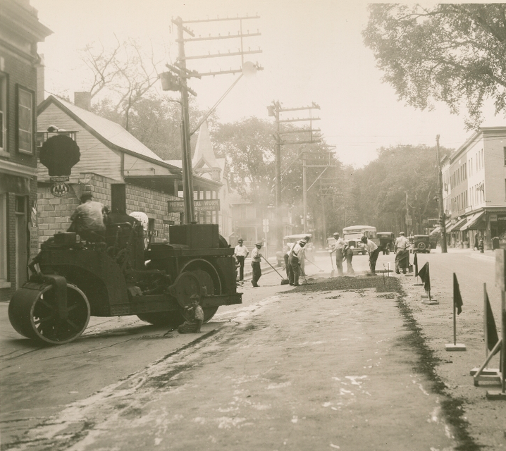
The dramatic changes are seen in the following photos. The first photograph, taken by local professional photographer Louis McAllister in the summer of 1934 shows a road paving crew working in front of the properties discussed.49 The second photograph taken in the late 1960’s shows the service station.50 Though taken at a different angle, the open sight lines spoken of in the Burlington Free Press article are clearly seen. Note in the latter photograph the opposite corner lot is occupied by a Gulf Service Station, a busy intersection indeed.
.jpg)
This structure served as gas station until the mid-1970’s when it was expanded and remolded into a pizza parlor.51 From this remodel to the present, restaurants of one kind or another have occupied 191 Pearl Street including Zachary’s Pizza, Valencia Tapas Bar and since 2003, Asiana House.52
Overview Revisited
The contrast from the Church Street as depicted in the 1860’s panorama to today’s densely populated commercial core is stark and profound. Yet as shown in this study, what stands now is directly influenced by what stood in the past and the physical changes, excluding the quick razing and erections of buildings, follow a slow arc of development. The same changes can be said regarding the social uses of the block. Starting as almost entirely domestic properties, the gradual introduction of domestic scale businesses, boarding houses & livery stables, slowly grew until the commercial development of the corner lots resulted in the last domestic properties existing in the upper floors of 187 Pearl Street.
Changes are constantly happening all around so much so that it goes unnoticed even though it’s happening right in front of us. Unfortunately it’s when things are completely gone that we notice that something is different. Luckily though, maps, photos and the now ubiquitous selfies posted to social media will help future historians dig through the past and add layers to known histories.
NOTES
1. Burlington 1885, sheet 03, Special Collections, University of Vermont , http://cdi.uvm.edu/collections/item/btvfi_1885_003 (accessed October 22, 2017).
2. Burlington 1900, sheet 17, Special Collections, University of Vermont , http://cdi.uvm.edu/collections/item/btvfi_1900_017 (accessed October 22, 2017).
3. Burlington 1906, sheet 17, Special Collections, University of Vermont , http://cdi.uvm.edu/collections/item/btvfi_1906_017 (accessed October 22, 2017).
4. Photograph from Unitarian Church, 1860, Special Collections, University of Vermont Library.
5. David J. Blow, Historic Guide to Burlington Neighborhoods (Burlington: Chittenden County Historical Society, 1991), 44.
6. The Village of Burlington, Vermont, 1830, Special Collections, University of Vermont Library, http://cdi.uvm.edu/collections/item/Burlington_FreePress (accessed October 22, 2017).
7. Photograph from Unitarian Church, 1860, Special Collections, University of Vermont Library.
8. George Perkins Marsh Institute, “George Perkins Marsh: Renaissance Vermonter,” Clark University, https://www2.clarku.edu/departments/marsh/about/index.cfm.
9. David Lowenthal, George Perkins Marsh: Prophet of Conservation (Seattle: University of Washington Press, 2000), 45-46.
10. Burlington 1894, sheet 14, Special Collections, University of Vermont , http://cdi.uvm.edu/collections/item/btvfi_1894_014 (accessed October 22, 2017).
11. Burlington Free Press, March 12, 1895, 8; accessed at newspapers.com.; Burlington Free Press, July 20, 1895, 8; accessed at newspapers.com.; Burlington Free Press, October 3, 1895, 5; accessed at newspapers.com.; Burlington Free Press, October 23, 1895, 5; accessed at newspapers.com.; Burlington Free Press, June 13, 1895, 8; accessed at newspapers.com.
12. David J. Blow, Historic Guide to Burlington Neighborhoods (Burlington: Chittenden County Historical Society, 1991), 44.
13. Burlington Free Press, October 24, 1982, 78; accessed at newspapers.com.
14. David J. Blow, Historic Guide to Burlington Neighborhoods (Burlington: Chittenden County Historical Society, 1991), 44.
15. Ibid.
16. The Village of Burlington, Vermont, 1830, Special Collections, University of Vermont Library, http://cdi.uvm.edu/collections/item/Burlington_FreePress (accessed October 22, 2017).
17. Map of Burlington, Vermont, 1853, Special Collections, University of Vermont Library, http://cdi.uvm.edu/collections/item/Burlington_Presdee_1853 (accessed October 22, 2017).
18. Plan of the City of Burlington, Chittenden Co., Vt, Special Collections, University of Vermont Library, http://cdi.uvm.edu/collections/item/Burlington_Beers_1869 (accessed October 22, 2017).
19. Photograph from Unitarian Church, 1860, Special Collections, University of Vermont Library.
20. The village of Burlington, Vt, Special Collections, University of Vermont Library, http://cdi.uvm.edu/collections/item/Burlington_FreePress (accessed October 22, 2017).
21. Sanborn Fire Insurance Map, Burlington 1869, sheet 01, Special Collections, University of Vermont, http://cdi.uvm.edu/collections/item/btvfi_1869_001 (accessed October 22, 2017)., Sanborn Fire Insurance Map, Burlington 1885, sheet 03, Special Collections, University of Vermont, http://cdi.uvm.edu/collections/item/btvfi_1885_003 (accessed October 22, 2017).
22. Burlington Free Press, April 26, 1915, 7; accessed at newspapers.com.
23. Burlington Free Press, April 8, 1903, 3; accessed at newspapers.com.
24. Burlington Free Press, November 14, 1908, 16; accessed at newspapers.com.
25.Burlington Free Press, April 26, 1915, 7; accessed at newspapers.com.
26. Burlington Free Press, February 26, 1916, 8; accessed at newspapers.com.
27. Burlington and Winooski, Vermont Directory, Vol. XXVII (Springfield, MA: H.A. Manning Co, 1916), 145.
28. Burlington Free Press, April 8, 1924, 7; accessed at newspapers.com.
29. Ibid.
30. Burlington Free Press,August 10, 1926, 7; accessed at newspapers.com. Burlington Free Press, October 3, 1930, 24; accessed at newspapers.com.
31.Burlington Free Press, October 25, 1930, 15; accessed at newspapers.com.
32. Burlington Free Press, March 14, 1931, 12; accessed at newspapers.com.
33. Burlington Free Press, September 4, 1931, 2; accessed at newspapers.com.
34. Burlington Free Press, November 19, 1994, 40; accessed at newspapers.com.; Burlington Free Press, February 9, 1927, 16; accessed at newspapers.com.; Burlington Free Press, November 22, 1960, 3; accessed at newspapers.com.
35. Map of Burlington, Vermont, 1853, Special Collections, University of Vermont Library, http://cdi.uvm.edu/collections/item/Burlington_Presdee_1853 (accessed October 22, 2017).
36. The village of Burlington, Vt, Special Collections, University of Vermont Library, http://cdi.uvm.edu/collections/item/Burlington_FreePress (accessed October 22, 2017).
37. Burlington Free Press, January 27, 1869, 3; accessed at newspapers.com.
38. Burlington Free Press, February 17, 1869, 3; accessed at newspapers.com.
39. Burlington 1869, sheet 01, Special Collections, University of Vermont , http://cdi.uvm.edu/collections/item/btvfi_1869_001 (accessed October 22, 2017).
40. Map of Burlington, Vermont, Sanborn Map Company, 1942; Special Collections, University of Vermont.
41. City of Burlington, Vermont Property Database, accessed November 1, 2017, https://property.burlingtonvt.gov/PropertyDetails.aspx?a=5340.
42. Burlington Free Press, December 18, 1917, 7; accessed at newspapers.com; Burlington Free Press, February 4, 1935, 7; accessed at newspapers.com
43. Burlington Free Press, June 6, 1957, 4; accessed at newspapers.com.
44. Burlington Free Press, August 11, 1916, 7; accessed at newspapers.com.
45. Burlington Free Press, May 15, 1925, 19; accessed at newspapers.com.; Burlington Free Press, October 12, 1932, 16; accessed at newspapers.com.;Burlington Free Press, May 9, 1916, 12; accessed at newspapers.com.; Burlington Free Press, September 2, 1908, 16; accessed at newspapers.com.; Burlington Free Press, October 29, 1911, 7; accessed at newspapers.com.
46. Burlington Free Press, February 19, 1921, 12; accessed at newspapers.com.
47. Burlington Free Press, April 29, 1939, 13; accessed at newspapers.com.; Burlington Free Press, September 23, 1939, 13; accessed at newspapers.com.
48. Burlington Free Press, September 23, 1939, 13; accessed at newspapers.com.
49. Burlington Streets: Winooski Ave., Louis L. McAllister Photographs, Box A07, Folder 10, Item 12, http://cdi.uvm.edu/collections/item/mcalA07F10i12 (accessed October 22, 2017).
50. Burlington Street Views, University of Vermont, Special Collections.
51. Burlington Free Press, September 10, 1975, 27; accessed at newspapers.com.
52. Burlington Free Press, January 17, 1995, 9; accessed at newspapers.com.; Burlington Free Press, December 16, 2003, 29; accessed at newspapers.com.