 |
University Green Area Heritage StudyHistoric Burlington Research Project - HP 206Historic Preservation Program - University of Vermont |
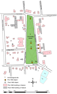
Burbank Archaeological SiteThis archaeological site is located between the Main Street Pumping House and City Reservoir on one side and Pomeroy Hall and the University of Vermont on the other side. During research for a 2002 investigation of the site, it was learned that a half acre lot on the site was originally purchased in 1822 by Joseph Burbank.(1) Burbank had his neighbor, John Johnson, draw a plan for a wood frame home that was built on the property using large timbers.(2,3) This frame house is shown on several contemporary maps through the nineteenth century, up to the 1890 Hopkins Map of Burlington.(4) Burbank was a blacksmith and had a separate outbuilding on the property for his Test pits were dug due to a 2002 project that had the potential to disturb the site. These pits identified the remains of the blacksmith shop, a residence, a well, and other artifacts from 1822-1891.(9) These artifacts included ceramic, bone, coins, tokens, brick, nails, and glass and many different types of fuel presumably used in Burbank’s shop.(10) 1996 excavations also revealed a fieldstone foundation that defines the western edge of the shop. On a Presdee and Edwards map from 1853, the Burbank’s shop is shown to be U shaped, opening toward Rt. 2.(11) This is an unusual building shape. It has three connected, but distinct sections indicative of additions or the need for separate work spaces for different tasks. Text by Rachel Peterson, 2011 (1)Baker, Charity M., Allen Hathaway, and Douglas S. Frink. Archaeological Studies of the Main Street Upgrade Project in the City of Burlington, Chittenden County, Vermont, MEGC 5000(14), (Essex Junction: Archaeology Consulting Team, Inc. , 2002), 64.
(2)Circa 1822 John Johnson plan of the Burbank house. Courtesy of UVM Special Collections.
(3)Architectural Plans and Drawings: J. Burbank House, March 1822, Courtesy of UVM Special Collections.
(4)Hopkins Map of Burlington, Vermont. 1890.
(5)Baker, Charity M., Allen Hathaway, and Douglas S. Frink. Archaeological Studies of the Main Street Upgrade Project in the City of Burlington, Chittenden County, Vermont, MEGC 5000(14), (Essex Junction: Archaeology Consulting Team, Inc. , 2002), 64.
(6)Baker, Charity M., Allen Hathaway, and Douglas S. Frink. Archaeological Studies of the Main Street Upgrade Project in the City of Burlington, Chittenden County, Vermont, MEGC 5000(14), (Essex Junction: Archaeology Consulting Team, Inc. , 2002), 67-70.
(7)Baker, Charity M., Allen Hathaway, and Douglas S. Frink. Archaeological Studies of the Main Street Upgrade Project in the City of Burlington, Chittenden County, Vermont, MEGC 5000(14), (Essex Junction: Archaeology Consulting Team, Inc. , 2002), 66.
(8)Sanborn Insurance Map. Burlington, VT. 1889 Sheet 15
(9)Baker, Charity M., Allen Hathaway, and Douglas S. Frink. Archaeological Studies of the Main Street Upgrade Project in the City of Burlington, Chittenden County, Vermont, MEGC 5000(14), (Essex Junction: Archaeology Consulting Team, Inc. , 2002), 66.
(10)Ibid.
(11)Baker, Charity M., Allen Hathaway, and Douglas S. Frink. Archaeological Studies of the Main Street Upgrade Project in the City of Burlington, Chittenden County, Vermont, MEGC 5000(14), (Essex Junction: Archaeology Consulting Team, Inc. , 2002), 67-70.
|