History
Maps Interactive Map
Photos
Resources Home |
|
|
|
Dorset
Vermont
|
|
A
Brief Agricultural History
|
|
|
|
Lucas F. Harmon
|
|
10/27/2009
|
|
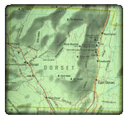
Figure 1.
Current map of Dorset, Vt.
|
Dorset,
Vermont is a town located within Bennington County in the southwest corner of
the State of Vermont. The town was chartered in 1761 as part of Governor
Benning Wentworth’s New Hampshire grants. A mountainous topography
characterizes the landscape of the town, with the Taconic Range running south
to north along the Dorset’s western border and the Green Mountains running
parallel along the eastern border. Rising prominently in the middle is Dorset
Mountain or Mount Aeolus, a formidable peak that breaks up the three villages
of the town. The head waters for
the Otter Creek and Battenkill rise in the eastern part of the town, while the
Mettawee River originates on the west side of Dorset Mountain. Dorset’s
mountains are the keepers of the town’s most valuable resource marble; however
the mountains also make suitable soil for growing crops hard to come by. The
town is described in the 1880’s as being well suited for grazing, soil of a
mostly gravelly loam and only “tolerably fertile”[1]
Rocky
soil and marble aside, agriculture has existed in Dorset throughout its
history. Sources of information on agriculture in the early years of the town’s
history are not easy to come by. One can imagine the difficult task of clearing
Dorset’s hills and tilling the soil for the first time like the town’s first
settlers did, just to farm on a subsistence basis. The first major commercial
agriculture industry in the town was wool production. Sheep were well suited for grazing on Dorset’s hillsides and
favorable tariffs and high wool prices made raising sheep a profitable
undertaking in Dorset as well as the rest of the state in the early half of the
19th century. The 1840 State Agriculture Census numbers Dorset’s
sheep population at 7,802 producing 16,080 pounds of wool.[2] In the same year Dorset’s human
population numbered just 1,432, leaving more than five sheep for every person
in town.[3]
The sheep boom would not last forever, as the repeal of protective tariffs and
subsequence competition from foreign markets drove the price of wool down. The
collapse of the wool prices is evident in a count of sheep from the 1850 State
Agriculture Census, which lists the total number of sheep in Dorset at 4,740,
nearly a forty percent decline from the decade earlier.[4]
|
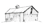
Figure 2. Ames Farm High Drive Barn, south and east elevations.
(Lucas Harmon, 2009)
|
 As
the century progressed, sheep were on their way out and dairy was on its way
in. The 1840 State Agriculture Census did not list a specific category for dairy
cows; this had changed for the 1850 census. Of the 137 farms listed in the 1850
census, only four farms As
the century progressed, sheep were on their way out and dairy was on its way
in. The 1840 State Agriculture Census did not list a specific category for dairy
cows; this had changed for the 1850 census. Of the 137 farms listed in the 1850
census, only four farms 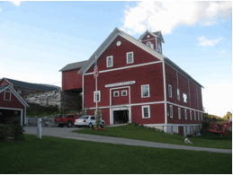 were listed as having ten or more dairy cows and 100
or more sheep. This suggests that Dorset farmers faced the choice of either
dairy or wool. Indeed the four farms in 1850 that had substantial numbers of
both were also large enough in terms of acreage to support both, ranging from
350 to 600 acres. Perhaps the most
striking example of the shift from wool to dairy is the case of the Ames farm.
In 1850, the Ames farm had thirteen dairy cows but still retained 400 sheep. By
1880, thirty two dairy cows occupied the farm and all
400 sheep were gone.[5] William Ames, proprietor of the farm
was active in Dorset; he is listed in Child’s Gazetteer as a town selectman, overseer
of the poor and town agent along with his occupation as a farmer.[6]
Successfully transitioning from wool to dairy, Ames produced 7,200 pounds of
cheese and 800 pounds of butter on his farm in 1880. Ames had a massive double
high drive barn built to accommodate his dairy herd (see figure 1.); the size
of barn reflects his success in the dairy business. Marble slabs make up the
ramp leading to the covered drives of the barn, an
example of how abundant the resource was in the area. Barns of this style were
commonly built in Vermont in the late 1800’s and early 1900’s, they
accommodated large dairy herds, while minimizing labor associated with moving
feed and manure.[7] Such
innovations to save on time and labor reflect the fact that dairying was more
labor intensive than raising other livestock such as sheep. The 1880 Vermont
State Agriculture Census includes a category for wages paid for farm labor
indicating the importance of hired labor and farm managers. An examination of
the 1880 census reveals that of the sixteen farms that paid $200 or more in
labor costs, only three were not dairy farms. The thirteen that were dairy
farms averaged nineteen milking cows and paid an average of $288 dollars for
farm labor.[8] were listed as having ten or more dairy cows and 100
or more sheep. This suggests that Dorset farmers faced the choice of either
dairy or wool. Indeed the four farms in 1850 that had substantial numbers of
both were also large enough in terms of acreage to support both, ranging from
350 to 600 acres. Perhaps the most
striking example of the shift from wool to dairy is the case of the Ames farm.
In 1850, the Ames farm had thirteen dairy cows but still retained 400 sheep. By
1880, thirty two dairy cows occupied the farm and all
400 sheep were gone.[5] William Ames, proprietor of the farm
was active in Dorset; he is listed in Child’s Gazetteer as a town selectman, overseer
of the poor and town agent along with his occupation as a farmer.[6]
Successfully transitioning from wool to dairy, Ames produced 7,200 pounds of
cheese and 800 pounds of butter on his farm in 1880. Ames had a massive double
high drive barn built to accommodate his dairy herd (see figure 1.); the size
of barn reflects his success in the dairy business. Marble slabs make up the
ramp leading to the covered drives of the barn, an
example of how abundant the resource was in the area. Barns of this style were
commonly built in Vermont in the late 1800’s and early 1900’s, they
accommodated large dairy herds, while minimizing labor associated with moving
feed and manure.[7] Such
innovations to save on time and labor reflect the fact that dairying was more
labor intensive than raising other livestock such as sheep. The 1880 Vermont
State Agriculture Census includes a category for wages paid for farm labor
indicating the importance of hired labor and farm managers. An examination of
the 1880 census reveals that of the sixteen farms that paid $200 or more in
labor costs, only three were not dairy farms. The thirteen that were dairy
farms averaged nineteen milking cows and paid an average of $288 dollars for
farm labor.[8]
|
Figure 3.
Post Card of Glen View Farm looking southeast, C.1925 (Courtesy of UVM
Special Collections.)
|
The
vast majority of dairy farmers sold their milk to creameries in the late 1800’s.
Only five farms in the 1880 reported making cheese on their farm, these farms were
large, the smallest milking sixteen dairy cows.[9]
There were two creameries in 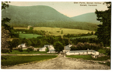 Dorset in the late 19th
century. One was started around 1870 by Augustin B. Armstrong,
on the way into Dorset Hollow; the other was that of the Dorset Dairy
Association, a stock company whose officers included several prominent dairy
farmers.[10]
These creameries would have played a key role in converting farmer’s perishable
raw milk into longer lasting products such as butter and cheese. In his town history,
Tyler Resch attributes the Dorset Dairy Association creamery with handling over
twelve thousand pounds of milk a day.[11] Dorset in the late 19th
century. One was started around 1870 by Augustin B. Armstrong,
on the way into Dorset Hollow; the other was that of the Dorset Dairy
Association, a stock company whose officers included several prominent dairy
farmers.[10]
These creameries would have played a key role in converting farmer’s perishable
raw milk into longer lasting products such as butter and cheese. In his town history,
Tyler Resch attributes the Dorset Dairy Association creamery with handling over
twelve thousand pounds of milk a day.[11]
While
dairy dominated by the end of the 19th century, a select few farmers
in Dorset still kept sheep, these were most likely
profitable as breeding stock rather than their wool production. William H.
Beebe, proprietor of the farm just to the north of William Ames, is such an
example keeping a flock of forty four sheep in addition to seventeen dairy cows
according to the 1880 census. The Barrows family of Dorset Hollow also retained
sheep. The 1880 census credits Philetus Barrows with raising eighty sheep and
eight dairy cows. An examination of the 1869 Beers map shows Philetus’
residence on town road eight (present day Upper Hollow Road) and owning property
on town road seven (present day Lower Hollow Road). The residence shown on the
Beers map was built by his father Experience in the early 1800’s and was known
as Glen View Farm.[12] Philetus
must have inherited the farm from his father. Child’s Gazetteer also list Philetus’ brothers Experience W. Barrows, and George
Barrows as also owning farms in Dorset Hollow.[13]
|
Figure 4. Current photo of
of the Glen Farm (Photo: Lucas
Harmon. 2009)
| |
A circa 1925 post card shows the Glen Farm and its surrounding fields in
the valley of Dorset Hollow (see figure 3). Warren Howe purchased the then
1,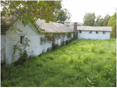 200 acre Glen View Farm in 1915 and it continued to operate as a dairy farm
until the 1950’s.[14] Howe had a water
wheel installed to provide power directly to the farm in
the 1920’s, this building is the first on the left of
the post card (Figure 3.) and provides a rational for the date. The Glen View Farm was run as a summer camp for children by the Wieneke
family from 1953 until 1965 when it was sold to the Tetzlaff family.
When rumors were confirmed that the Tetzlaff were planning to develop the
hollow and surrounding mountains into a 3,000 acre ski resort, residents of the
hollow successfully organized and the plan collapsed under heavy public
opposition.[15]
The Glen View Farm survives today, although not used for agriculture anymore it
still looks much as it did in the 1920’s post card. 200 acre Glen View Farm in 1915 and it continued to operate as a dairy farm
until the 1950’s.[14] Howe had a water
wheel installed to provide power directly to the farm in
the 1920’s, this building is the first on the left of
the post card (Figure 3.) and provides a rational for the date. The Glen View Farm was run as a summer camp for children by the Wieneke
family from 1953 until 1965 when it was sold to the Tetzlaff family.
When rumors were confirmed that the Tetzlaff were planning to develop the
hollow and surrounding mountains into a 3,000 acre ski resort, residents of the
hollow successfully organized and the plan collapsed under heavy public
opposition.[15]
The Glen View Farm survives today, although not used for agriculture anymore it
still looks much as it did in the 1920’s post card.
The number of farms in Dorset remained fairly constant through the mid
20th century. The 1945 Agricultural Census reported 137 farms
operating in town, just six less than the 143 reported in the 1880 census.[16] The 1945 census indicates that only
forty two percent of Dorset’s farms were milking dairy cows.[17]
The 1945 census does not provide nearly the level of detail as
the ones conducted in the 19th century, so it is difficult to
ascertain what Dorset farms were producing instead of
dairy. The 1945 census does show a significant increase in the acreage of
orchards, with sixteen farms reporting 492 acres of orchards (most likely apple
trees), this is compared with seventy three farms
reporting a total of 124.5 acres of orchard in 1880. [18] It seems
most of the 19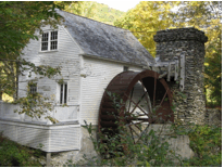 th century farms kept an acre or two of land in apples
probably for their own consumption and use, by 1945 commercial apple production
became the primary focus of a small number of farms. Today there is still one
commercially operating in East Dorset, Mad Tom Orchard. th century farms kept an acre or two of land in apples
probably for their own consumption and use, by 1945 commercial apple production
became the primary focus of a small number of farms. Today there is still one
commercially operating in East Dorset, Mad Tom Orchard.
|
Figure 5 This
water wheel powered the Glen Farm in the early 1900's (Photo: Lucas Harmon.
2009)
|
Today Dorset does not retain much of its agricultural industry. This is
the trend for many Vermont towns today. In 2002, the United States Department
of Agriculture listed the total number of farms in Bennington County at 228.[19]
On a recent trip to Dorset to conduct a survey of existing farm buildings in
the town, I did not notice very many working farms left in the town. Dorset is known more for being the
ideal, picturesque Vermont town rather than its agricultural heritage. A
careful drive through town with a discerning eye will reveal a large number of
agricultural buildings, some have been adapted for new uses, others stand in
disrepair, but they serve as a 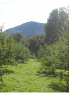 reminder of the
history of farming in Dorset nonetheless. reminder of the
history of farming in Dorset nonetheless.
|
Figure 6. A view of Mount
Aeolus looking southwest from Mad Tom Orchard. ( Photo: Lucas Harmon, 2009)
|
[1] Hamilton Child, Gazetteer and Business Directory of
Bennington County, VT 1880-1881 (Syracuse, 1880), 122.
[2] United States Census
Bureau, Vermont State Agriculture Census 1840.
[3] Hamilton Child, Gazetteer and Business Directory of
Bennington County, VT 1880-1881 (Syracuse, 1880), 28.
[4] Vermont State
Agriculture Census 1850.
[5] United States Census
Bureau, Vermont State Agriculture Census 1880.
[6] Hamilton Child, Gazetteer and Business Directory of
Bennington County, VT 1880-1881 (Syracuse, 1880), 299.
[7] Thomas D. Visser, A Field Guide to New England Barns and Farm
Buildings (Hanover: University of New England Press, 1997), 85.
[8] United States Census
Bureau, Vermont State Agriculture Census 1880.
[9]United States Census Bureau, Vermont
State Agriculture Census 1880
[10] Tyler Resch, Dorset: In the Shadow of the Marble Mountain
(Knowlton & McLeary Co., 1989), 161.
[11] Tyler Resch, Dorset: In the Shadow of the Marble Mountain
(Knowlton & McLeary Co., 1989), 161.
[12] Hamilton Child, Gazetteer and Business Directory of
Bennington County, VT 1880-1881 (Syracuse, 1880), 127.
[13] Hamilton Child, Gazetteer and Business Directory of
Bennington County, VT 1880-1881 (Syracuse, 1880), 300.
[14] Tyler Resch, Dorset: In the Shadow of the Marble Mountain
(Knowlton & McLeary Co., 1989), 312.
[15] Tyler Resch, Dorset: In the Shadow of the Marble Mountain
(Knowlton & McLeary Co., 1989), 326.
[16] United States Census Bureau, Vermont
State Agriculture Census 1945; United States Census Bureau, Vermont State
Agriculture Census 1880.
[17] United States Census
Bureau, Vermont Agricultural Census 1945.
[18] United States Census Bureau, Vermont
State Agricultural Census 1945; United States Census Bureau, Vermont State
Agricultural Census 1880.
[19] United States
Department of Agriculture, Census of Agriculture, 2002. Http://www.agcensus.usda.gov/Publications/2002/ .
Bibliography:
Child, Hamilton. Gazetteer and Business Directory of
Bennington County, VT for 1880-1881. 1880: The Journal Office, Syracuse.
Resch, Tyler. Dorset: In the Shadow of the Marble Mountain
. Knowlton & McCleary Co., 1987.
United States Bureau of Census, Vermont
State Agricultural Census, 1840.
United States Bureau of Census, Vermont
State Agricultural Census, 1850.
United States Bureau of Census, Vermont
State Agricultural Census, 1880.
United States Bureau of Census, Vermont
State Agricultural Census, 1945.
United States Department of Agriculture,
Census of Agriculture, 2002.
Vissor, Thomas. Field Guide to New England Barns and Farm
Buildings. Hanover: New England University Press, 1997.
|