|
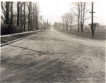
Flynn Avenue (formerly Park Avenue, changed 1934) looking west from almost Shelburne Road |
April 27, 1931; Louis L. McAllister |
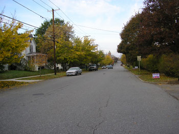
October 22, 2006, Brandee Wagner: 180642444E; 4923990N; 190ft. |
Taken in April of 1931, this McAllister photograph shows just one in a series of steps involved in paving the streets of Burlington. In this case, Flynn Avenue is the project area. Considering the rapid growth of the Ferguson & Scarff Addition, it is interesting to note that this section of Flynn Avenue is not as densely populated as other areas by this time. However, according to the 1938 Burlington City Report, “this section of the city has increased in population and building developments faster during the last few years than any other section of the City.”(1) After the completion of the projects on Flynn Avenue, structures appeared more and more rapidly in the directories and on the Sanborn Maps.(2) Following from the right, in the distance is a large brick building. This is the Champlain School, located on Pine Street,(3) fully two and a half blocksaway from the location of the photo. In the center of the photo, the steeple of Saint Anthony’s French Roman Catholic Church. Saint Anthony’s was built in 1902 to serve the large French Canadian community that was rapidly moving into the new Ferguson & Scarff Addition. (4)The house closest to McAllister’s position is number 433 Flynn Avenue. The resident of this dwelling at the time was Eugene J. White. White is identified in the directory as the president, treasurer, and manager of E. J. White Paint and Glass Company, located at 123 St. Paul Street,(5) illustrating the “commuter” residence that Ferguson & Scarff served as.
(1) 73rd Report of the City of Burlington, Vermont 1938 (Burllington: Free Press Printing Co.), p169. (2) Manning's Burlington & Winooski Directory for year 1931-1942 (Springfield H.A. Manning Co); Insurance Map of Burlington, VT (New York: Sanborn Map Company, 1942). (3) Go to: Champlain School Information (4) Go to: St. Anthony Information (5) Manning's Burlington & Winooski Directory for year 1931 (Springfield H.A. Manning Co).
|
Today, the area is much more heavily settled, and serves as a mainly residential area, as originally intended by Ferguson and Scarff’s plan. The trees have grown in on both sides of the street and some low shrubbery has been added. The entire look of the streetscape changes drastically when more houses and trees come into the neighborhood. No longer can one look past almost three blocks’ worth of open field and view Pine Street goings-on. Saint Anthony’s steeple is no longer visible, either, as the tree line has grown up considerably. The street is also now lined with houses on both sides, from the corner of Flynn Avenue and Shelburne road (behind the photographer) heading west through the intersections with Wells Street, Richardson Street, and Pine coming in to complete the settlement of the area by 1960.(1)
(1) Insurance Map of Burlington, VT (New York: Sanborn Map Company, 1942, 1960). |
Historic Burlington Project |