|
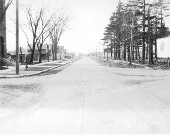
Flynn Avenue (formerly Park Avenue, changed 1934) looking west from intersection with Pine Street |
November 14, 1931; Louis L. McAllister |
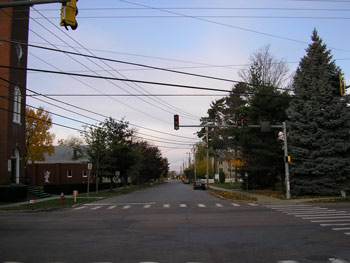
October 22, 2006; Brandee Wagner: 180642088E; 4924011N; 164ft. |
Here at the intersection of Flynn Avenue and Pine Street, we see Saint Anthony’s Roman Catholic Church. Built in 1902(1) the Church was meant to serve the French Roman Catholic population that rapidly filled the new Ferguson & Scarff Addition and the surrounding areas.(2) In 1931, the year the photo was taken, St. Anthony’s Roman Catholic School opened. Sanborn maps identify the school building as a combination building, serving as both a school and a convent.(3) The structure cannot be seen in the photograph, as it was located behind the church, situated in the southeast corner of the lot. In the right of the picture, a billboard sits conspicuously. It is unclear, however, what it is advertising for. Notice in the distance past the billboard how clear the space is. Those long buildings seen in the distance down the street are actually part of the industrial complex at 207 Flynn Avenue.(4)
(1) Insurance Map of Burlington, VT (New York: Sanborn Map Company, 1919); Manning's Burlington & Winooski Directory for year 1903 (Springfield H.A. Manning Co). (2) Insurance Map of Burlington, VT (New York: Sanborn Map Company, 1919). Manning's Burlington & Winooski Directory for year 1903(Springfield H.A. Manning Co). (3) Insurance Map of Burlington, VT (New York: Sanborn Map Company, 1932). (4) Go to: 207 Flynn Avenue Information
|
The trees in the sidewalk in front of the church eventually made way for the church hall, appearing in sometime between 1960 and 1978.(1) In 1971, the Saint Anthony Roman Catholic School closed,(2) and by 1978 the building had been demolished.(3) Today the site of the former school/convent now serves as a parking lot for the church. Though some exterior changes have been made to the church, including a new steeple (not seen in this photograph) and new front stairs, the same statue of Saint Anthony remains in the side courtyard. Some more significant changes in the neighborhood have been the growth of residents in the area and the increasing traffic on Pine Street and Flynn Avenue through the years. The tree growth has also changed the look of this intersection dramatically. No longer are the front yards and silhouettes of personal homes exposed. The billboard seen in the McAllister photo is also blatantly missing from the 2006 streetscape. Instead, a large pine tree takes its place, thanks to the Vermont law that banned billboards in 1969.(4) Today, the corner lot behind the pine tree is occupied by Howard Center for Human Services.
(1) Insurance Map of Burlington, VT (New York: Sanborn Map Company, 1960, 1978). (2) Manning's Burlington & Winooski Directory for year 1971/72 (Springfield H.A. Manning Co). (3) Insurance Map of Burlington, VT (New York: Sanborn Map Company, 1978 |
Historic Burlington Project |