Grove Street: North from Bridge UTM: 180644373E; 4927245N |
 Louis L. McAllister August 15, 1939 |
|
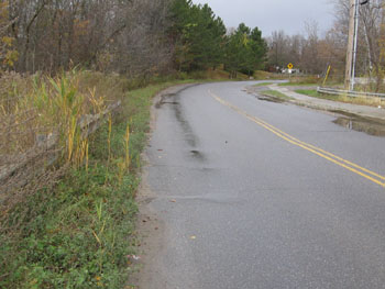
| Louis McAllister took this photograph, dated August 15, 1939, while standing on the new Grove Street Bridge looking north. The bridge itself is completed, but the city is in the midst of a street paving project. The westerly portion of the pavement (on the left) had been completed, but the east side is unfinished. In addition, the city is installing perforated corrugated metal pipe at the left for underground drainage purposes. The white house visible further along Grove Street is the home of Wilfred C. Kirby at 63 Grove Street. Kirby owned and operated a plant at 100 Grove Street during this era. The Burlington directory suggests that throughout the 1930s and 1940s the business grew from "trucking" to "ready mix concrete, contractor, and excavating" in 1954[1], the approximate year of his death. His wife, Mrs. Madeleine F. Kirby, continued to live at 63 Grove Street and act as administrator of the estate after 1956[2] and the Burlington directory suggests that the plant continued operation at 100 Grove Street until approximately 1974.[1] Burlington City Directory, 1954 (Burlington: H. A. Manning Co., 1916-1986)
|
Today, the bridge is only distinguishable from the road by two guardrails where the bridge's parapet walls used to be. To view a close up of the bridge today, accompanied by a description, please click here. Although obscured by trees, the sloped area on the left hand side of the road in Louis McAllister's photograph has since been transformed into a park. In 1942, the Parks Commissioners noted in the Annual Report, "An important addition to the city's park system came in the form of two parcels of land, totaling approximately seven acres and located on Grove Street. This was the gift of Mrs. Pearl E. Schmanska, in memory of her late husband, and is to be fully developed for both a summer and winter playground."[1] The park featured a playground, baseball field, skating rink and warm up house, toilet facilities and other attractive facilities. Very soon after its opening, Schmanska Park was already a source of community pride. "A fine spirit of civic cooperation has developed around this park with neighbors joining together along with their children in planning and conducting a wholesome and varied program," wrote W. L. Hammond, Superintendent of Parks, in 1943.[2] Today, the baseball field and skating rink are gone, having been replaced by tennis and basketball courts. Schmanska Park also offers a large playground and indoor meeting facilities in its barn. The historic barn, which appears in the background of severalother historic McAllister photographs, was recently renovated by William Maclay Architects & Planners of Waitsfield, Vermont. The firm's website testifies that all work was done "within historic preservation requirements" and "existing siding, trim, cupola and other historic features were maintained."[3] The barn is obscured by tree growth in contemporary photos taken from McAllister's viewpoints, but to see a picture of the barn as it stands today, please click here. [1] Burlington City Annual Report, 1942, p. 129. |
Historic Burlington Project Depression Era Streetscapes: Old North End | Burlington 1890 | Burlington 1877 | Burlington 1869 | Burlington 1853 | Burlington 1830 Produced by University of Vermont Historic Preservation Program graduate students in HP 206 Researching Historic Structures and Sites - Prof. Thomas Visser - in collaboration with UVM Landscape Change Program Historic images courtesy of University of Vermont Library Special Collections, Louis L. McAllister Photograph Collection |