
| Introduction |
1830 marked an important turning point in the history of Burlington, Vermont. No longer just another Vermont village, Burlington had entered a period of brisk growth that would last for over a half century and transform it into Vermont's largest city. Set on a terraced ridge between Lake Champlain and the mighty natural falls of the Winooksi River, Burlington's location provided easy access to both international water-borne commerce and one of the most powerful mill sites in the region. With the 1823 opening of the Champlain Canal that provided a continuous water route from Lake Champlain to the Hudson River and New York City, Burlington's importance grew swiftly, and by 1830 it was becoming the leading center of commerce and industry on Lake Champlain and in Vermont. From the village's busy shipping and mercantile center clustered along the waterfront one could walk several blocks east to the civic and business center on the Church Street and continue east up the hill through the desirable residential area along Pearl Street to the University of Vermont at the crest of the ridge.
From the perspective of American architectural history, 1830 also marks a turning point in the transition from the Federal style that had dominated architectural design since the 1790s, to the new Greek Revival style that would flourish on through the 1840s.
 It
was in this context that the ambitious young architect, Ammi Burnham
Young (1798-1874), arrived in booming Burlington in May of 1830.
Perhaps drawn on commission or perhaps produced as a clever promotional
piece, Young created a "Plan
of the Village of Burlington, Vermont" that year. This
map, published as a lithograph by "Pendleton, 157, Broadway"
shows the locations and rough footprints of about 553 buildings.
This is the oldest known street map of its type of Burlington.
An original lithograph of the map is held by the University of
Vermont Library Special Collections.
It
was in this context that the ambitious young architect, Ammi Burnham
Young (1798-1874), arrived in booming Burlington in May of 1830.
Perhaps drawn on commission or perhaps produced as a clever promotional
piece, Young created a "Plan
of the Village of Burlington, Vermont" that year. This
map, published as a lithograph by "Pendleton, 157, Broadway"
shows the locations and rough footprints of about 553 buildings.
This is the oldest known street map of its type of Burlington.
An original lithograph of the map is held by the University of
Vermont Library Special Collections.
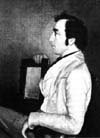
A native of Lebanon, New Hampshire, Young's career as an architect flourished soon after he arrived in Burlington as he produced such buildings in the Greek Revival style as the Vermont State House in Montpelier, 1833-37; Timothy Follett House in Burlington, 1840; Wheeler House in Burlington, 1842; and the Federal Customs House in Boston, Massachusetts, 1837-47. His reputation grew nationally as he served as the Supervising Architect for the U. S. Treasury Department from 1852-1860, where he was responsible for the designs of many customs houses and post offices constructed around the country. Vermont examples of these include post offices in Windsor and Rutland (later converted into a library). The portrait of Ammi B. Young shown at the left was painted by C. Rogers in 1846 and is in the collection of the Vermont Historical Society.
Like snapshots that freeze a moment of the ever-changing past, few archival documents provide such rich insights into the physical history of communities as do historic street maps. Indeed for researchers studying historic sites and changes in the built environment, this is one of the most important types of archival evidence available.
With these two questions in mind, graduate students in UVM Professor Thomas Visser's Researching Historic Structures and Sites course launched a semester-long research project in the fall of the year 2000. Working in cooperation with library professor Jeffrey Marshall and the staff at the UVM Library's Special Collections, the team researched the entire area encompassed by Young's 1830 map. This area extends from the Lake Champlain waterfront east to the UVM Green and from North Street south to below Maple Street. Each student researched a section of the area, using historic maps and other primary historical evidence. They then surveyed downtown Burlington, street by street, building by building, documenting physical clues of architectural evidence that suggested pre-1830 construction dates. Through this research, each student compared the information shown on the 1830 Young map and other archival evidence with the physical evidence that survives on the streets today to develop lists of buildings sorted into the following categories:
The researchers then compared their findings with such secondary sources of historical information as National Register historic district nominations, the Vermont Historic Sites and Structures Survey, and books written about the history of Burlington and its neighborhoods. Follow-up research was then conducted using land record deeds and probate court records. The lists were again revised and the students mapped their findings. It should be noted that this study just covers the downtown portion of Burlington included in Ammi B. Young's map of Burlington Village. A few other pre-1830 buildings survive in other parts of the city of Burlington, including the Ethan Allen Homestead in the intervale and some near Winooski Falls.
To help correlate the 1830 map evidence with what stands in Burlington today, Professor Visser made high resolution scans of the original 1830 map at UVM Library's Special Collections. He also scanned 1988 aerial photos of the city. These images were then digitally transformed to approximately the same scale and superimposed then atop each other for the comparative overlay maps included in this site.
Although Young's hand-drawn map is generally accurate, he took minor artistic latitudes that become apparent when viewing the comparative overlay map. He renders proposed rights-of-way for some streets that were not built, for example, and some building locations are approximate. Although many of the street names shown by Young are still in use today, some have changed since 1830. These are listed in the street index included in this site.
|
University of Vermont Historic Preservation Program in cooperation with UVM Library Special Collections |
Continue to the 1830 Young map