
We measure sediment and solids suspended in the water in milligrams/liter of sampled water. TSS or Total Suspended Solids refers to the solids and sediments suspended in water samples, and high levels found in storm flows are typically indicative of erosion. The turbidity, or relative cloudiness, of the water will be influenced by the amount of TSS present in the sample. Typically, a higher TSS value will increase the turbidity of the water. As a reference, the photo below shows water of relatively high turbidity.
At our sampling stations in Tributary 7 of the Potash Brook, there have been measurements of TSS as high as 70 mg/l, with a flow rate as high as 5.0 cubic meters (5000 liters) per second during an extreme storm event. At this peak condition more than 0.75 pounds of sedimentper second could flow through the tributary. It is no surprise that sediment deposits such as depicted below occur downstream from the sampling station; what is not deposited locally continues on toward Lake Champlain.

Sediment pollution is not specific to Vermont. For example, the Wisconsin Department of Natural Resources (DNR) has estimated that construction sites, on a per acre basis, contribute as many as 60,000 pounds of sediment per year to downstream locations, compared to cropland, which contributes 2,000 - 20,000 pounds per year.
As suburban communities are developed, sediment generation is an issue; following construction, it is reported that multi-family developments deliver as many as 400 pounds per acre.* This sediment burden is carried by increased stormwater volume resulting from increased development.
The photographs from Tributary 7 shown below are not isolated examples; the dynamics of erosion portrayed are symptomatic of the Potash Brook watershed. Increased impervious surface areas with suburban development continue to stress the watershed. Enhanced sediment loading places a significant burden on both the downstream receiving waters and on the fragile ecosystem of Lake Champlain.

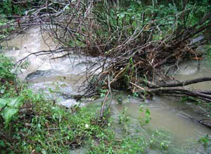
As the tributaries flood and are filled with wash-out debris, the creek bed is forced from the natural channel. Cutting a new channel will dislodge more sediment.
The U.S. EPA notes that increased stormwater volumes and velocities associated with development within a watershed may also result in the scouring of wetland substrates if Best Management Practices (BMPs) are not in place to slow and reduce flows...**
*GWQ020 Polluted Urban Runoff - A Source of Concern I-02-97-5M-20-S DNR: WT-483-97
**EPA 841-B-01-001 June 2001