NSF NEESR-Payload Project
This research is an outcome of the National Science Foundation 07-506
program solicitation "George E. Brown, Jr. Network for Earthquake
Engineering Simulation (NEES) Research" competition. This project was awarded as a
NEESR-payload. This project was led by the
University of Vermont and included a subaward to Prof. Pedro deAlba of the University of New
Hampshire.
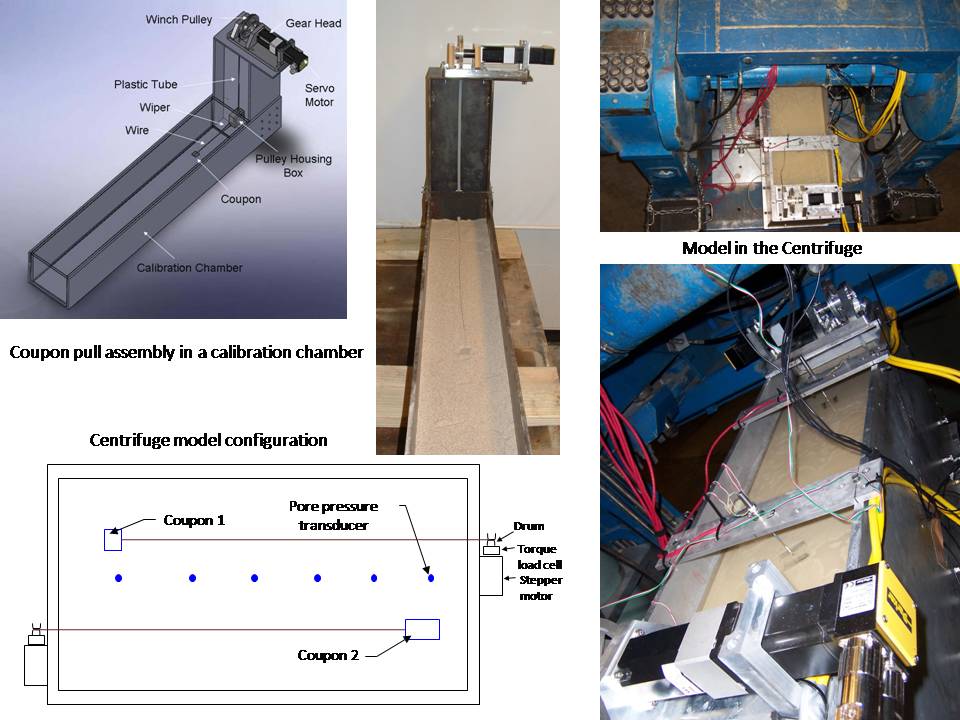
It has long been observed that saturated sands subjected to
shock or earthquake loading experience drastic loss of strength and
behave as heavy fluids, gradually regaining strength as internal water
pressures dissipate. As long as the liquefied state persists, the soil
will flow down slopes, producing destructive landslides and large drag
forces on obstacles such as piled foundations. Modeling this behavior
for risk studies and engineering design, however, requires adequate
measurements of how shearing strength is lost and is eventually recovered
as internal water pressures build up and subsequently dissipate.
There are currently no full-scale field measurements of these strength
changes to guide development of such models; existing field case
histories are limited to observing the final damage produced by the
liquefaction process. Controlled laboratory measurements would be
desirable, but the onset of liquefaction is accompanied by such large
strains that soil samples in conventional laboratory tests become so
drastically deformed that reliable strength measurements can no longer
be made. As a first step in measuring the evolving behavior of
liquefied sands, it was envisioned that the shear strength of liquefying
sand can be measurable in-flight in a seismic geotechnical centrifuge
model using a thin coupon (plate, about 25 millimeters by 75
millimeters by ~1.5 millimeters) pulled horizontally through the soil
model, with its major dimensions parallel to the base of the model. The
large strains and strain rates associated with liquefaction flow
failures would thus be simulated by moving the coupon relative to the
sand, through and after the shaking until the excess pore pressures
dissipate. By measuring the drag force on the coupon, it was
possible to observe the evolution of the soil shear strength as it
decreases to a minimum (residual strength) and subsequently increases
as pore pressures dissipate. The centrifuge results were compared to
companion ring shear tests.
Equipment
required to conduct the payload tests was designed and built by a group
of undergraduate mechanical and
electrical engineering students at the University of Vermont as their
senior capstone design project, and calibrated before installation by a
civil engineering undergraduate student. The UVM civil engineering
undergraduate student and UNH graduate student conducted centrifuge
tests at the University of Colorado at Boulder. The companion ring
shear tests were conducted at UNH.
Data
from this project is archived in the NEES data repository.
Publications from this work to date:
- Dewoolkar,
M. M., Hargy, J., Anderson, I., de Alba, P., and Olson, S. M. (2016),
"Residual and postliquefaction strength of a liquefiable sand," Journal
of Geotechnical and Geoenvironmental Engineering, 142(2), 10.1061/(ASCE)GT.1943-5606.0001374.
- Anderson,
I., Dewoolkar, M., Hargy, J., and de Alba, P. (2014), "Measurement of
post-earthquake strength of liquefiable soils in centrifuge models,"
8th International Conference Physical Modeling in Geotechnics, Perth,
Australia.
- Anderson,
I., Hargy, J., de Alba, P., and Dewoolkar, M. M. (2012), "Measurement
of residual strength of liquefied soil in centrifuge models",
GeoCongress 2012 Conference, Oakland, CA.
- Dewoolkar,
M., Anderson, I., de Alba, P., and Hargy, J. (2010), Measurement of the
Strength of Liquefied Soil in Physical Moels, a report submitted to the
National Science Foundation
VTrans - Bridge Scour Project
 Tropical Storm Irene had unprecedented impacts on transportation infrastructure in
numerous regions of New England states and the state of New York. In Vermont
alone, more than 300 bridges were damaged, which motivated this study Successfully
mitigating scour and erosion related problems is dependent on our
ability to
reliably estimate scour potential, design effective scour prevention
and
countermeasures, design safe and economical roads and bridges
accounting for
erosion potential, and design reliable and economically feasible
monitoring
systems. These demand numerous research needs spanning from
first-principle micro
to system-level macro scales, which are currently underway in
collaboration with Professors Donna Rizzo, Dryver Huston, Jeff Frolik
and Yves Dubief. At the micro scale, understanding at the level of
a soil particle is needed; i.e. how soil particles get lifted by
flowing water,
how the soil type affects its erosion potential, and what are the
associated
critical stresses and velocity of water especially under highly
turbulent conditions
during extreme events. First principle understanding of these
mechanisms is
underway by capturing concepts from the field of computational fluid
dynamics
(CFD) and general advancements in numerical simulations, computing
power and
visualization tools. An example of an intermediate scale study would
be developing accurate and passive, yet low-cost sensing and monitoring
technologies - a scour sensor is under development. An example of a
system-level macro-scale study is developing a link between
bridge scour and system-level geomorphic assessment of rivers and
streams. Scour is affected by the geometries of the channel and the
banks,
flows, soils types and numerous other factors including human
interference.
Therefore, it is very difficult to develop a physics-based model that
can
reliably predict scour potential. On the other hand, modern numerical
tools
such as artificial neural networks can detect
non-linear interrelations among variables, rank variable importance,
and yield
semi-empirical correlations that include rating schemes. About 1,370
stream
miles (~2,500 stream reaches) in Vermont has been assessed with
reasonable
details for their geomorphic conditions including characteristics of
the valley
and floodplain corridor, the bankfull channel, riparian areas, evidence
of flow
modification and bed or planform changes;
providing unique opportunities for linking these assessments to observed
or predicted scour and erosion.
Tropical Storm Irene had unprecedented impacts on transportation infrastructure in
numerous regions of New England states and the state of New York. In Vermont
alone, more than 300 bridges were damaged, which motivated this study Successfully
mitigating scour and erosion related problems is dependent on our
ability to
reliably estimate scour potential, design effective scour prevention
and
countermeasures, design safe and economical roads and bridges
accounting for
erosion potential, and design reliable and economically feasible
monitoring
systems. These demand numerous research needs spanning from
first-principle micro
to system-level macro scales, which are currently underway in
collaboration with Professors Donna Rizzo, Dryver Huston, Jeff Frolik
and Yves Dubief. At the micro scale, understanding at the level of
a soil particle is needed; i.e. how soil particles get lifted by
flowing water,
how the soil type affects its erosion potential, and what are the
associated
critical stresses and velocity of water especially under highly
turbulent conditions
during extreme events. First principle understanding of these
mechanisms is
underway by capturing concepts from the field of computational fluid
dynamics
(CFD) and general advancements in numerical simulations, computing
power and
visualization tools. An example of an intermediate scale study would
be developing accurate and passive, yet low-cost sensing and monitoring
technologies - a scour sensor is under development. An example of a
system-level macro-scale study is developing a link between
bridge scour and system-level geomorphic assessment of rivers and
streams. Scour is affected by the geometries of the channel and the
banks,
flows, soils types and numerous other factors including human
interference.
Therefore, it is very difficult to develop a physics-based model that
can
reliably predict scour potential. On the other hand, modern numerical
tools
such as artificial neural networks can detect
non-linear interrelations among variables, rank variable importance,
and yield
semi-empirical correlations that include rating schemes. About 1,370
stream
miles (~2,500 stream reaches) in Vermont has been assessed with
reasonable
details for their geomorphic conditions including characteristics of
the valley
and floodplain corridor, the bankfull channel, riparian areas, evidence
of flow
modification and bed or planform changes;
providing unique opportunities for linking these assessments to observed
or predicted scour and erosion.
The geo-referenced data on damaged (and non-damaged) Vermont bridges from the 2011 Tropical Storm Irene can be downloaded from: ____________________________
