Main to College: A History of the East Side
By Samantha Johnson
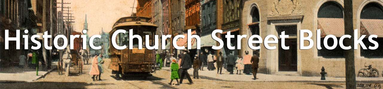
Church Street is one of Burlington’s defining features. It plays a central role in commerce and tourism in Vermont’s Queen City as well as provides a gathering space for community events. The character of this bustling thoroughfare, whose storefronts shine by day and whose trees twinkle at night, complements Church Street’s physical function as a hub for the downtown area.
The section of Church Street between Main and College streets has long acted as a gateway into the city’s downtown, especially since it became closed off to vehicle traffic in 2004, finally joining the rest of the Church Street pedestrian mall that had developed in the 1980s.1 As people enter downtown Burlington from the University of Vermont campus to the east, the intersection of Main and Church streets provides a fulcrum from which to branch out, leading west to Lake Champlain, south to a residential district, and north to the commercial nucleus. Though City Hall dominates the western side of Church Street and is certainly a focal point, the eastern block balances the streetscape and was one of the earliest sections of the street to develop.2 It is the latter part of this section that is the focus of this research.
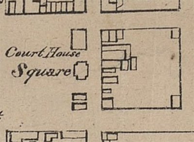
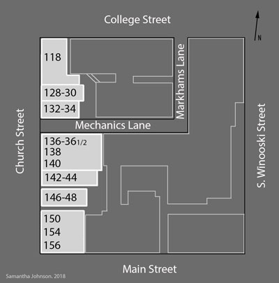
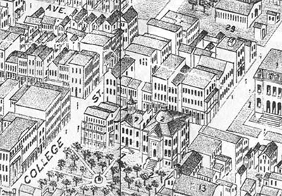
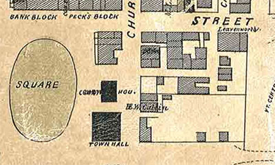
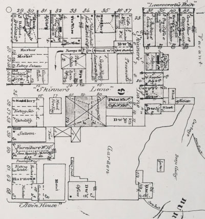
According to Ammi Burnham Young’s 1830 map, from when Burlington was still a village, the portion of Church Street between Main (then Fayette) and College was already one of the most densely developed sections, showing eight structures and matched only by its northern counterpart between College and Bank streets (Fig. 2).3 Furthermore, the development of this block as a whole represents the historic relationship between commerce and industry in the Burlington area. While the Church Street side of the block has historically been dominated by commercial interests, the side facing Winooski Avenue (White Street in 1830) originally developed as a cluster of industrial structures, as evidenced by the L-shaped alley that cuts into the block connecting Church and College, which was first called Skinners Lane for the tannery there and subsequently renamed Mechanics Lane as a result of the growth of mechanized sectors such as printing and automobiles.4 Although many of the structures along Church Street have been altered or replaced over time, many of the building footprints remain similar, if not identical, to their predecessors. Those standing today allow us to trace the block’s development along with that of the city, from the earliest structure, dating to circa 1853, at #146-148 to the 1926 high-style Burlington Trust Company bank at the intersection of Church and College.
118/120-126 Church Street
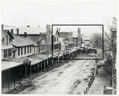
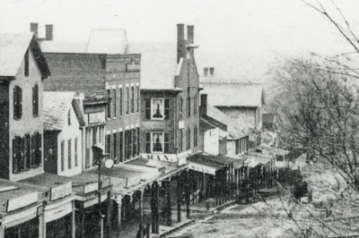
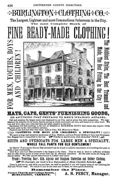
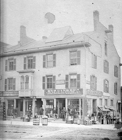
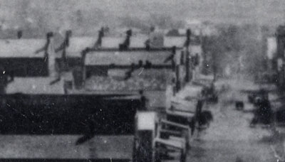
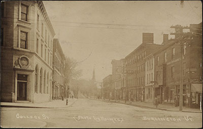
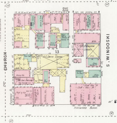
As the northern anchor point of this block on Church Street, it is no surprise that a building has occupied the site since at least 1830.5 Mid- and late-19th-century photographs and maps reveal that the same structure stood at this spot for decades, housing a clothing store on the first level. The earliest photographic evidence of the three-story, side-gabled, three by four bay, masonry structure is a photograph from the 1860s looking south down Church Street towards College (Figs. 3a-b). This image shows the two chimneys and parapets at either end as well as the prominent central skylight rising from the peak. More extensive visual evidence can be found in a full-page advertisement for Burlington Clothing Co. in Hamilton Child’s 1882-83 Gazetteer and photograph circa 1890 (Fig. 4-5).6 These later images reveal further detail and show that the six-over-six sash windows were replaced with four-pane sashes and the roof redone in metal sometime within the intervening decades. While the basic structure appears little-changed, one of the second-story, stone-lintelled windows on the north façade was replaced by a bay window prior to the 1880s. A business directory published around 1905, Burlington of Today, claims that the building was constructed in the 1830s, as a photography studio had been established there for over seventy years.7 Based on these sources, the gabled roof visible in the 1860 panoramic view of Church Street looking south from the Unitarian Church and the building depicted in the 1877 bird’s eye view map of Burlington appear to belong to the same structure (Figs. 6a&b-7). The 1885 Sanborn map also offers further insight – it documented a metal cornice on the north (College Street) façade and the presence of a basement. The south façade also had three windows with metal shutters across on each floor, except the westernmost one on the first floor due to a small one-story structure at 124 Church Street.8
These photographs and directories document the presence of a clothing store at this address operated by different proprietors until the 1910s. The Burlington of Today directory lists both James A. Kelley, the proprietor of Stiles & Kelley since the 1880s, and B. Benton Barker, who rented the photography studio on the second floor. Prior to its demolition in 1925, the first floor operated briefly as Paul D. Kelley’s grocery store.9 In addition to the third-floor photography studio that operated until 1925, the second floor was rented by a dentist and as offices throughout much of the 19th century, of which a sign for the former is visible in the 1890 photograph.10 Early twentieth-century photographic postcards of Church Street also reveal glimpses of the building (Fig. 8-9).11
The property discussed above eventually became #118-22 on Church Street. The narrow lot next door, #124 did not have a structure on it until the 1880s. The 1885 Sanborn map was the first one to show a small, almost square, one-story, composition-roofed building there, occupied by a news dealer.12 The building was enlarged in the 1890s, doubling the footprint, and by 1900 it was two stories tall with a tin or slate roof. From around 1894 to 1912, #124 was a florist shop operated by John Wilson. By 1912, it had reverted to its one-story, composition-roofed 1890s form and by 1919, the property had been absorbed by its southern neighbor, #126.13
Before 1869, the property now designated as 126 Church Street was alternately vacant or occupied by structures spanning what is now #126-130. According to the 1869 Sanborn map, there was a one-and-a-half-story, wood-framed commercial building covering these two properties. It was divided into three equal sections, designated from north to south as a barber shop, market, and eating saloon, respectively.14 By 1885, #126 had its own independent structure, a one-story, composition-roofed meat market.15 Five years later, it appears that a second story was added and the building was roofed with tin or slate. M. S. Storrs sold meat and poultry there in the 1880s.16 The 1894 Sanborn indicates that #126 was connected to #128-130, with only frame partitions separating the various commercial spaces.17 F. Howes & Co. briefly occupied the building around 1900, between their move from #136 to #134 and the structure remained thus into the early 1900s, until it was subdivided into two commercial properties, numbered 126 and 126A from south to north, housing a tailor and a fruit shop, respectively.18 By 1912, the properties had merged again and accommodated a barbershop.19 In the last years before being subsumed by the construction of the Burlington Trust Company bank next door, #126 enveloped #124, comprising a one-story, wood-framed, composition-roofed restaurant, Burlington Lunch.20
Why do these buildings matter if they are no longer standing? It is the story of those structures that do not remain and that were not extensively recorded that can offer further depth and new insight into the history of a place. While this building was replaced with a beautiful, high-style Colonial Revival structure in 1926 that should certainly be celebrated as a significant part of Church Street’s history, the vernacular building that preceded it is just as important to the city’s development. Despite its apparent solidity and decent size, it is not altogether surprising that it was replaced by new construction in the 1920s, especially when one considers the circumstances behind the current Colonial Revival building (Fig. 10). Its predecessor’s outdatedness is suggested by its glancing inclusion in the edges of some early 20th-century images. Where before it had been the subject of photographs, it was relegated to the wings towards the end of its life. The 19th-century building had been constructed when Burlington was still a village and the new Burlington Trust Company bank represented the city’s prosperity and growth.
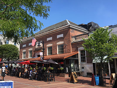
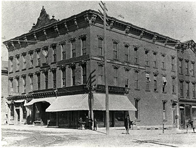
Founded in 1882, the Burlington Trust Company first operated as a de facto private bank for the wealthy Wells family, who commissioned the new headquarters in 1925. This distinguished Burlington family, which owned the Wells Richardson Company, had made its fortune in the late 19th century through patent medicine manufacturing. In 1925, the trust commissioned New York City architect, James W. O’Connor, to design the Colonial Revival two-story, three-by-five bay structure fronting Church Street.21 The 1926 Sanborn map recorded the then in-construction building’s composition as loadbearing brick masonry with steel and cement floor and ceiling and a slate-shingled wooden roof. It also denoted the one- and two-story additions to the east and south, all with composition roofing, the latter of which enveloped the adjacent properties of #124 and #126a.22 In May of 1925, the Burlington Free Press noted that the building’s marble, brick, and slate were all being sourced from Vermont.23 The result, which still commands this intersection, features elegant marble details. These comprise the prominent water table, denticulated cornice, balustrade atop the one-story wings, window lintels and sills as well as rectangular footed tablets inset above each window, an elaborately carved door surround, and a plaque above the entry engraved with “Burlington Trust Co. 1882-1826.”
The Burlington Trust Company operated independently until 1952 when it merged with the Howard National Bank directly opposite it on the northeast corner of Church and College. In that year, the building was sold to Miles & Riley, proprietors of a men’s clothing store that operated until 1969, when the Kennedy Brothers Company purchased the property to use as a retail outlet for their novelty wood-working business in conjunction with their Vergennes factory. Finally, this iconic property was purchased by Tony Perry in 1981, who opened the Sweetwaters Restaurant that still occupies the site. Perry commissioned Montpelier architect Lawrence Atkin to redesign the interior for his restaurant, and in the same year, local artist Wendy Coop painted a large mural inside illustrating Burlington’s history.24 Despite these alterations, the interior retains many of its original finishes and has become one of Church Street’s most well-known icons.
128-130 Church Street
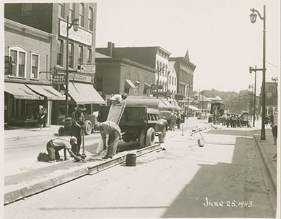
Buildings of various size have stood at this site since at least 1830. A large rectangular structure is visible on Ammi Burnham Young’s map and the 1853 and 1857 maps by Presdee & Edwards and H.E. Walling, respectively, show an even bigger block occupying #126-130 (Figs. 2 and 11). The latter footprint may belong to the same building recorded on the 1869 Sanborn map, which shows a one-and-one-half story structure divided into even thirds. The shops were occupied from north to south by a barber, a market, and an eating saloon. Subsequent maps, beginning with the 1885 Sanborn map, show remarkably similar footprints of two-story frame commercial blocks, with varying subdivisions for the changing shops within. For instance, the 1885 Sanborn map shows a bisected structure matching that of today, which housed a news and confectionary shop at #128 and a tobacconist at #130. Thus, the two-story, wood-framed structure currently occupying #128-130 may date to the late 19th century. By 1894, #128 was a barbershop and #130 was the Star Restaurant, which soon relocated to #144, and in 1900, the barbershop had become Paul D. Kelley’s grocery store, which remained there until the late 1910s, when Kelley moved to #118 briefly before that structure was demolished. #130 was a photography studio from about 1905 to 1940, operated first by H. E. Cutler and later by Hollis W. Clark. By 1919, the front and rear façades had been faced with brick, as is visible in one of Louis McAllister’s photographs from 1943 (Fig. 12).25 Here, a simple wooden, bracketed cornice is visible above windows taller and narrower than those present now. A striped awning extended across both storefronts and shop signs projected perpendicular to the façade. The building was open on the first floor until the early 1940s, when it was subdivided to accommodate two storefronts, Gover’s Radio Shop at #128 and Tanner’s Barber Shop at #130. In the rear of #130 was a bakery, first operated by Tom Hargreaves, which soon filled the first-floor shop as the Pure Food Bakery.26
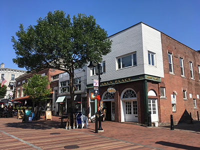
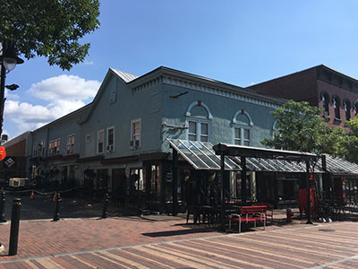
The façade was rebuilt again circa 1965 in its present Moderne-style form (Fig. 13).27 White square Carrara glass panels were installed on the second floor, punctuated by two sets of two rectangular tripartite windows. The storefront below features a recessed central entryway to both shops and is composed of large plate glass windows framed in stainless steel and surrounded by black Carrara glass pilasters and skirting. Between the two stories is a stainless-steel cornice band, from which two small, symmetrical awnings extend over their respective storefronts. The northern shop, now numbered #126, has housed Global Pathways, a jewelry and mineral store, since 1996 and the southern one, now #128, is currently rented by Maven, a skateboard lifestyle boutique. The second floor now hosts a design firm. Although this building’s original structure is no longer readily visible, its distinctive façade is one of the few Carrara glass façades remaining on Church Street and reflects the street’s continuous change and development throughout the 20th century.
132-134 Church Street
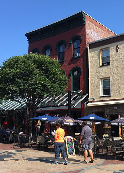
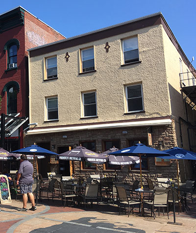
This lot on Church Street has been occupied by a structure since 1830, before Mechanics Lane bisected the block.28 The footprint of its predecessor first appeared on the 1853 Presdee & Edwards map of Burlington, shown on the north side of Mechanics Lane.29 While little detail about the very first building at the site survives, more insight is available regarding the structure that stood there from at least 1853 to 1900. The front half was a two-story, side-gabled, shingle-roofed, loadbearing masonry structure, almost square in plan. In the 1860s, it was divided into two shops on the first floor, a glazier to the north and a grocer to the south, with a barbershop on the second floor. To the rear, at 12 Skinner’s Lane, was a one-and-a-half-story, wood-framed structure of the same footprint that connected to the glazier next door and also housed a tailor.30 By 1885, the roof had been redone in slate or tin and the wood-framed structure had been enlarged or replaced by a two-part, two-storied, shingle-roofed one occupied by a glazier to the west and a gunsmith to the east.31 In spite of its total reconstruction in 1901, the first floor of #132-134 remained a meat market from the late 1880s through 1960, which was operated by F. Howes & Co. upon construction of the new building.32
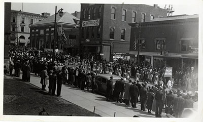
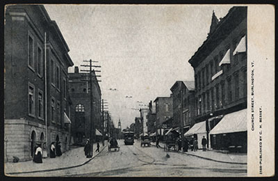
This reconstruction was necessitated by a fire in 1900 that destroyed the building.33 Named the Hyland Block, the new structure occupied the same footprint but on a grander scale (Fig. 14). As it currently stands, the historic character of what was originally a three-story, four-by-six bay, loadbearing masonry commercial block has been obscured by multiple alterations (see Fig. 13). The original commercial block featured a wooden cornice facing Church Street and one over one double-hung sash windows on each facade, which were arched on the third story of the west façade and flat-topped elsewhere. They had granite impost blocks flanking brick lintels; granite was also used for the sills and a tablet centered beneath the cornice engraved with “HYLAND.” Most of these elements are legible in a circa 1941 photograph of a parade on Church Street and are confirmed by a less-detailed postcard from the 1900s (Figs. 14 & 9). While it remained in its original form, the Church Street façade was also decorated with striped awnings and business signs for F. Howes & Co., which sold meat there for almost half a century, as well as various upstairs tenants. In the first two decades of the 20th century, the upper floors were rented by Company M of the Vermont National Guard, followed by Bethel Lodge, No. 22, Knights of Pythias.34 The second floor briefly housed a suspender factory in the 1910s and the Burlington Production Credit Association rented space during the 1930s and 1940s.35
Fire struck the building sometime in the 1960s, destroying the third floor and spurring the reconstruction of the west façade, wrapping around the south corner, with white-painted brick on the second story and unpainted red brick below punctuated by large arched openings.36 These arches enclose semicircular fanlights above recessed French doors, which open into Ake’s Place, the bar that currently occupies it. The second-floor windows were replaced with two evenly-spaced tripartite picture windows and the entire second-story façade projects a few inches past the first-floor storefront below. The windows of the south façade, facing Mechanics Lane, are a mixture of historic and new openings. Altogether, the significant alterations to the Hyland Block have prevented it from being included on the National Register as a contributing building in the Church Street Historic District.37
Like its southern neighbor, this property is linked to Mechanics Lane, which extends along its south façade into the heart of the block. In addition to physical proximity, this relationship is also evidenced by the nature of the lot’s rear occupants before the structure was rebuilt as a single masonry block in 1900. The industrial nature of the tenants fronting Mechanics Lane during the end of the 19th century reflect that of the rest of the inhabitants of the alley. In addition, a large storage facility, which also housed a harness shop and shed, extended from Mechanics Lane behind #126-134 on Church Street to abut the structures on College. In the 1890s, this complex was acquired and reconstructed by the Burlington Free Press to house their printing and bookbinding operations (Fig. 15). The large three-story masonry block connected to their College Street offices via a walkway between the upper stories.
136-140 Church Street
In 1830, this property was occupied by two narrow structures fronting Church Street and by the 1850s, a large square building sat at this corner of Church Street and Skinners Lane. Based on similarities between photographs from the 1860s and 1918, it appears that this structure is that which remains today (see Fig. 3b & Fig. 16). In the 1860s, this two-story, wood-framed building was divided into three narrow storefronts fronting Church, with one-story additions across the east façade corresponding to the storefronts. It housed, from north to south, a saddler, an eating saloon, and an upholsterer.38 This structure was replaced by a similar one in the 1870s.39 This new shingle-roofed structure measured two stories on the southern two thirds (#138-140) and two and a half stories at #136. The former two addresses each retained their rear one-story addition, while the latter had a two-story one at 5 Mechanics Lane.40 The Hotel Champlain, operated by W. B. Craven, occupied the upper stories of these addresses above its restaurant from the 1880s through the 1900s.41 #136 housed a fish and oyster dealer in the 1880s, then F. Howes & Co.’s meat market throughout the 1890s, until they moved across Mechanics Lane to #134 in 1901. Two small, two-story trade shops next door on Mechanics Lane merged with the building in the 1890s. They housed variously a carpenter, glaziers, painters, and cobblers as well as other small businesses, until eventually combining with #136.42 They remain thus today, comprising the rear section of the bar Red Square. By 1900, the roof had been redone in metal and #136 was occupied by Bessey’s News Co., which operated there through the 1960s. During the early 20th century, this commercial block also became more complex. #140 was subdivided in the 1900s and #136½ was shaved off of #136 by 1926, when it was a shoe shine parlor. A photograph from 1918 shows part of the clapboard façade with shuttered windows above on the second story and retracted awnings over the storefronts below (Fig. 16).
In the 1920s, the west façade was extended upward to its present form so that only the top third of the gable roof survives, though the full length of its eastern slope is also visible on the north façade. Concurrently, the Church Street section of the block was parged with stucco on its west and north façades (Figs. 14&17). Replacing their shuttered predecessors are four large window bays, each with a pair of one over one double-hung sash panes. Above each bay is an applied semicircular arch with a keystone and imposts at the lintel level. This addition is capped by a bracketed wooden cornice on both façades. The rear structures along Mechanics Lane that had been incorporated into the complex are still clapboarded, with a simple wooden cornice and a variety of window openings. The Church Street façade originally had fabric awnings on both stories, as seen in some of Louis McAllister’s 1943 photographs, but they have since been removed (see Fig. 12). The same type of glass and steel awning that was installed at various parts of the street spans the entire west façade here, unifying the varied storefronts below. Beginning in the 1930s and throughout the middle of the 20th century, this block housed a series of beauty parlors and barbershops, above which real estate and insurance agencies rented office space. The architecture firm of Freeman, French, Freeman and the Vermont YWCA both rented space at #138 in the 1930s and 40s. At the ground level between #138, which is currently operated as a tattoo parlor, and Red Square at #136 is the Half Lounge speakeasy at #136 ½, which housed a ladies’ clothing shop during the mid-20th century. Edythe A. Bushnell founded the Bushnell Shop there in 1935 and operated it until her retirement in 1953, upon which Mr. and Mrs. Fletcher T. Kenyon purchased it and continued its operation through the 1970s.43 After the closure of Hotel Champlain, #140 became a barbershop for much of the 20th century, operated in turn by Eldon H. Dickson and Ancel R. Godette.44 It is currently home to the Red Onion Café.
142-144
The three-story Italianate building at 142-144 Church Street was constructed in 1866, though a structure of the same footprint has occupied the site since at least 1830 (Fig. 18).45 Hiram H. Reynolds commissioned this loadbearing brick building after purchasing the property in 1864, which then housed Enos Peterson’s store. The day after it opened in December 1866, the Burlington Daily Times hailed Reynolds’ restaurant as a first-class eatery, which the young city had been sorely lacking. The building and its furniture, which was described as “neat but not gaudy,” cost $10,000 altogether and while well-equipped, there was “no elaboration of ornament about the premises.”46 In light of this claim and upon examination of the 1869 Sanborn map, it appears that the bracketed wood cornice was installed later, though not much because it is in keeping with the Italianate style and appeared on the next Sanborn map of 1885.47 The earliest photographs of the building from the 1900s confirm the presence of this cornice, which remains today along with the Italianate window surrounds. The round-arched, two over two single-hung windows on the second and third stories are capped by arched wooden window hoods ending in pendants. At the base of each is a wooden sill with cast-iron tulip-feet moldings on either end. Louis McAllister’s photographs of the street from 1943 reveal that the west façade was painted a light color with contrasting finishes sometime in the early to mid 20th century, which are shown in a circa 1960 color postcard to have been cream with light blue trim.48 The storefront is the only part of the exterior to show significant change as it has been repeatedly altered by various tenants. The doors to #142 and #144 appear to be in their original location at the north end of the façade, based on early 20th-century photographs in which the storefront is not obscured by an awning. Indeed, striped fabric awnings were still installed until the 1960s on the first floor and those above (see Fig. 16).
Perhaps the intactness of this building’s historical fabric is in part due to the consistency of its use over time. Since it opened 162 years ago, it has always housed a restaurant on at least the first floor. Reynolds operated his dining saloon until 1895, when W. C. Hoag bought it and changed the name to the Star Restaurant, which became the Lotus Restaurant from 1947 through the late 1970s.49 It has operated as an Asian restaurant since 1921 under a succession of different owners.50 In 2016, Gaku Ramen became the latest in the legacy of such restaurants at this site.
146-148
The building located at 146-148 Church Street is the oldest one on this part of the block, dating to at least the early 1850s, when it appeared on the Presdee & Edwards map of Burlington.51 The site appears to have been vacant on Ammi Burnham Young’s 1833 map, though it is possible that the small, narrow structure north of the block at the intersection of Church and Main streets was located at #148, not #150 (see Figs. 2 & 11). This three-bay, three-story, loadbearing brick structure had a gable roof, a wooden cornice with eave returns, and a small arched opening at the attic level until a fire in February 1970 (Fig. 19).52 A photograph from 1918 shows simple one over one double-hung sash windows with thin sills on the second and third floors, which remain today. Between the third-floor windows are two low-relief medallions that are likely bosses that anchor tie rods. The storefront originally had a door at the northern end and one in the center, flanked by display windows. The retractable fabric awning is the only surviving element on the façade’s first floor (see Fig. 16). Various signage also adorned the façade over the years, reflecting the tenants within. In the mid-twentieth century, the storefront was covered in black Carrara glass. The upper stories’ façade is the result of the 1970 fire, after which the brick bearing wall facing Church Street was parged with stucco.53 This and the unaltered south façade have been painted light yellow. Below, the storefront was covered with a rough-cut, random-coursed stone veneer in 2008.54
The building was used early on as a furniture warehouse in the 1860s and by the 1880s had become Jones & Isham’s flour, feed, grain, and hay store, which they operated until the 1910s. Various barbers have rented space here almost continuously since the 1880s and #148 has housed a restaurant since the 1920s, including Burlington Lunch and Hi-Hat Restaurant.55
150-156 Church Street
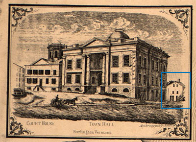
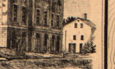
The intersection of Main and Church streets has long operated as a key fulcrum on which Burlington pivots. The northeast corner of this intersection has been occupied by a building since at least 1830.56 That early recording shows a sizeable square footprint. Maps from 1853 and 1869 show that the structure had been enlarged or replaced by a bigger building, which is visible behind the Town Hall in a detail from the 1857 Walling map (Fig. 20a-b). This image shows a three-story, gable-roofed structure with a chimney towards the east end.57 This structure was enlarged or rebuilt and combined with its Main Street neighbor in 1868 to form the Allen House, a complex composed of five sections of varying height and use (Fig. 21). Facing Church Street were three storefronts with much the same footprint as the site’s current building. The northern two were three stories tall and housed an eating saloon and harness store on the first floor with a barber above. The third section, that on the corner, was five stories tall and occupied by a “Huckster.” Facing Main Street were two more three-story portions housing a gunsmith on the west and a large hotel on the east from which the block derived its name. Behind the roadside buildings were also a spacious yard and stables to house horses and carriages.58
While these maps offer limited insight into the material composition of the Allen House, contemporary newspapers provide a glimpse into the lives of its inhabitants. However, one such article does also suggest that the Allen House was constructed of loadbearing masonry, because it announced that the city’s Battery of Artillery were removed from the building’s basement in 1871.59 This structure, like its successor, served a variety of uses from commercial to residential. The newspaper ad that announced the opening of the hotel in December 1868, first operated by Rollin Pease and Orvis S. Storrs, also mentioned the adjacent barber’s shop and a livery.60 Weeks later, an advertisement for a doctor practicing there was published, soon followed by further notices of events and marriages taking place at the Allen House. By 1871, #152 housed Lyman & Allen’s, a specialty dry goods store, and Drew & Davis sold shoes at #154.61 Despite, or perhaps because of, the success of businesses here in the early 1870s, not all press was positive.62 The newspaper’s court recordings document repeated fines charged to the proprietors of the Allen House for selling liquor in addition to short articles expressing nuisance complaints in the vicinity.63 Not only were there complaints about the refuse dumped onto the sidewalk from windows above and the hotel’s raucous nightly concerts, this part of town was also apparently host to some unsavory characters and their dealings.64
Perhaps because of a desire to improve the property or because of economic hardship for its owners, by 1877, the Allen House was in decline. Newspapers from spring of that year announced that portions of the complex were being torn down to make way for a new pair of structures, beginning with the Vermont Life Insurance Company building at 176-178 Main.65 These fashionable, complementary Italianate buildings were praised for their style and construction and the Exchange Block (almost called the Centennial Block) quickly asserted its presence at the intersection.66 Applauded by the Burlington Free Press in a lengthy article, this “substantial and elegant three-story brick building” was “an ornament to the city, a credit to its projectors, and a gratifying indication of the business prosperity of our city.”67 Similar in footprint to the west end of the Allen House block, this new structure also comprised three storefronts on Church Street (150-152, 154, 156) and a diverse collection of tenants above. These storefronts were predominantly composed of iron and sheets of plate glass measuring 84 by 124 inches. The ornate window lintels and five-foot-high bracketed cornice were manufactured in galvanized iron.68 These elements survive today, but the elaborate rooftop plate, also of galvanized iron, that stretched the width of #154 and bore the block’s name was unfortunately lost to a fire in 1962 that destroyed the third floor of #150-154.69 The 1878 article detailing its construction also stated W. H. Townsend as the project supervisor and carpenter as well as described the interior of #156, which initially opened as E. P. Shaw’s clothing store.70 The ornate exterior was matched by a handsome interior with thirteen foot ceilings. The floor was of maple and the ceiling also paneled in wood, while the walls and shelving were painted white. An ash counter and tables furnished the space along with a large mirror at the rear. The eastern door on the Main Street façade led up to four rooms on the second floor and as many on the third.71 Those on the second story were rented out to businesses, while the third was for residential use. The building was heated by a boiler in the basement and each floor was equipped with water and gas, washstands and urinals. This new structure was celebrated by Burlington residents, who gathered on the evening of April 2, 1878 to see the storefront of #156 lit for the first time.72
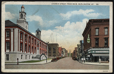
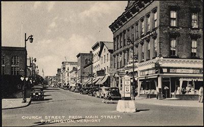
The construction of the Exchange Block reflected the prosperity and continuing growth of the city in the latter half of the nineteenth century and its popularity since has been recorded by postcards and photographs that have captured its dynamic storefront for almost a century and a half (Figs. 22-24). An early image from the 1890s shows large striped awnings sheltering the storefronts and some of the upper windows. For the first forty years or so, #156 contained a clothing store.73 It was briefly a pharmacy becoming devoted to the food industry, first as the Burlington Sweet Shop and then as a series of restaurants beginning with Upton’s Sandwich Shoppe.74 It is still a restaurant today – now home to Honey Road, an eastern Mediterranean mezze, which even serves a cocktail named after this iconic Church Street block.75 Though not occupying the prime corner real estate, the other two storefronts of the Exchange Block are prominent as well and have hosted a series of grocers and restaurants. For instance, in the 1880s, W. B. McKillip & Co. sold all manner of “fancy groceries” at #154 and the Burlington Fruit Co. operated out of #150 from around 1906-1926. By 1912, Enos A. Howard had acquired #154, in which he opened first a cigar store and then Howard’s Grill, a restaurant that also included billiards and bowling.76 The second- and third-floor spaces were, like #156, rented out to both professionals and residents. One long-term resident was Miss Mary E. McCarthy, a tailoress who rented a room at #152 from about 1900 to 1926.77

While the storefronts have changed somewhat since the Exchange Block’s construction, the metal cornice above them remains intact except on #150 and the fabric awnings have been replaced with the glass and steel ones installed elsewhere on Church Street (Fig. 25). Yet despite these alterations to the structure, including the loss it sustained from the 1962 fire, and its setting, the building retains much of its original character. It certainly has not lost the dignity granted to it by its prominent position at the intersection of Church and Main streets. And while much of the city has continued to develop around what was once an imposing structure compared to its neighbors, it has in no way been swallowed by those other monumental buildings in its vicinity – rather it constitutes an integral piece in the eclectic quilt of downtown Burlington.
NOTES
1. John Briggs, "Church St. Work Begins Today," The Burlington Free Press, April 19, 2004, 9.
2. Ammi Burnham Young, Plan of Burlington Village, map (Burlington, Vermont: 1830). Accessed through Special Collections, University of Vermont Library, October, 2018.
3. Ibid.
4. National Register of Historic Places Nomination: Church Street Historic District, Chittenden County, Vermont. Burlington, VT: Vermont Division for Historic Preservation, 2010, 63.
5. Ammi B. Young, Plan for Burlington Village.
6. Gazetteer and Business Directory of Chittenden County, Vermont, for 1882-83 (Syracuse, NY: Hamilton Child, 1882), 434.
7. Burlington of Today: The Metropolis of the Green Mountain State (Kinderhook, NY: Industrial Advertising Company of America, C. 1905), 8.
8. Sanborn Fire Insurance Maps from Burlington, Chittenden County, Vermont, map (New York, NY: Sanborn Map Company, 1885), Sheet 4. Accessed through Special Collections, University of Vermont Library, September, 2018.
9. Burlington and Winooski City Directory: 1894 (Burlington: L. P. Waite, 1894). Burlington of Today, 8. Burlington and Winooski City Directory: 1926 (Springfield, MA: H. A. Manning Co., 1926).
10. Sanborn Fire Insurance Maps from Burlington, (1885), Sheet 4. Sanborn Fire Insurance Maps from Burlington, Chittenden County, Vermont, map (New York, NY: Sanborn Map Company, 1889), Sheet 4. Accessed through Special Collections, University of Vermont Library, September, 2018. Sanborn Fire Insurance Maps from Burlington, Chittenden County, Vermont, map (New York, NY: Sanborn-Perris Map Company, 1894), Sheet 17. Accessed through Special Collections, University of Vermont Library, September, 2018. Sanborn Fire Insurance Maps from Burlington, Chittenden County, Vermont, map (New York, NY: Sanborn-Perris Map Company, 1906), Sheet 23. Accessed through Special Collections, University of Vermont Library, September, 2018. Sanborn Fire Insurance Maps from Burlington, Chittenden County, Vermont, map (New York, NY: Sanborn Map Company, 1919), Sheet 16. Accessed through Special Collections, University of Vermont Library, September, 2018.
11. J. J. Stoner, Birds eye view of Burlington and Winooski, VT. [map] Accessed through Special Collections, University of Vermont Library, October, 2018. Postcard, c. 1900-1910, looking north on Church Street from Main Street, 2010.1.594. Llewellyn Collection of Vermont History, Special Collections, Champlain College. Accessed November, 2018.
12. Sanborn Fire Insurance Maps from Burlington, (1889), Sheet 4.
13. Sanborn Fire Insurance Maps from Burlington, (1894), Sheet 17. Sanborn Fire Insurance Maps from Burlington, Chittenden County, Vermont, map (New York, NY: Sanborn-Perris Map Company, 1900), Sheet 22. Accessed through Special Collections, University of Vermont Library, September, 2018. Sanborn Fire Insurance Maps from Burlington, (1906), Sheet 23. Sanborn Fire Insurance Maps from Burlington, Chittenden County, Vermont, map (New York, NY: Sanborn Map Company, 1912), Sheet 17. Accessed through Special Collections, University of Vermont Library, September, 2018. Sanborn Fire Insurance Maps from Burlington, (1919), Sheet 16.
14. Sanborn Fire Insurance Maps from Burlington, (1889), Sheet 4.
15. Sanborn Fire Insurance Maps from Burlington, (1885), Sheet 4.
16. Sanborn Fire Insurance Maps from Burlington, (1889), Sheet 4.
17. Sanborn Fire Insurance Maps from Burlington, (1894), Sheet 17.
18. Burlington and Winooski City Directory: 1900 (Burlington: L. P. Waite, 1900). Sanborn Fire Insurance Maps from Burlington, (1906), Sheet 23.
19. Sanborn Fire Insurance Maps from Burlington, (1912), Sheet 17.
20. Sanborn Fire Insurance Maps from Burlington, (1919), Sheet 16.
21. National Register of Historic Places Nomination, 71-72.
22. Sanborn Fire Insurance Maps from Burlington: Including Shelburne and Queen City Park, Chittenden County, Vermont, map (New York, NY: Sanborn Map Company, 1926), Sheet 2.
23. "Vermont Products," The Burlington Free Press, May 19, 1925, 4.
24. National Register of Historic Places Nomination, 72.
25. Sanborn Fire Insurance Maps from Burlington, Chittenden County, Vermont, map (New York, NY: Sanborn Map Company, 1869), Sheet 2. Accessed September 2018. Sanborn Fire Insurance Maps from Burlington, (1885), Sheet 4. Sanborn Fire Insurance Maps from Burlington, (1894), Sheet 17. Burlington and Winooski City Directory: 1900. Burlington and Winooski City Directory: 1906 (Burlington: L. P. Waite, 1906). Burlington and Winooski City Directory: 1912 (Burlington: L. P. Waite, 1912). Burlington and Winooski City Directory: 1942 (Springfield, MA: H. A. Manning, 1942). Sanborn Fire Insurance Maps from Burlington, (1919), Sheet 16.
26. Burlington and Winooski City Directory: 1942. Nathan Nirenstein and M.L. Bowers, Business Section, City of Burlington (Vermont), map (Springfield, MA: Nirenstein’s National Realty Map Co., 1946).
27. National Register of Historic Places Nomination, 65.
28. Ammi Burnham Young, Plan of Burlington Village.
29. Presdee and Edwards, Map of Burlington, Vermont, map (New York, NY: Sarony & Major, 1853).
30. Sanborn Fire Insurance Maps from Burlington, (1869), Sheet 2.
31. Sanborn Fire Insurance Maps from Burlington, (1885), Sheet 4.
32. Burlington and Winooski City Directory: 1884-5 (Burlington: Free Press Association, 1884). Burlington and Winooski City Directory: 1900. Burlington and Winooski City Directory: 1960 (Springfield, MA: H. A. Manning, 1960).
33. National Register of Historic Places Nomination, 65.
34. “Knights in New Rooms,” The Burlington Free Press, Sept. 6, 1905, 8.
35. Burlington and Winooski City Directory: 1906. Burlington and Winooski City Directory: 1912. Burlington and Winooski City Directory: 1935 (Springfield, MA: H. A. Manning, 1935). Burlington and Winooski City Directory: 1942. Nirenstein and Bowers, Business Section, City of Burlington.
36. National Register of Historic Places Nomination, 65.
37. Ibid.
38. Ammi Burnham Young, Plan of Burlington Village.
Presdee & Edwards, Map of Burlington, Vermont. Sanborn Fire Insurance Maps from Burlington, (1869), Sheet 2.
39. National Register of Historic Places Nomination, 63.
40. Sanborn Fire Insurance Maps from Burlington, (1885), Sheet 4.
41. Burlington and Winooski City Directory: 1889/90 (Burlington: L. P. Waite, 1889), 114. Burlington and Winooski City Directory: 1906 (Burlington: L. P. Waite, 1906), 196.
42. Sanborn Fire Insurance Maps from Burlington, (1894), Sheet 17.
43. “Deaths and Funerals,” The Burlington Free Press, Sep. 6, 1966, 14. “Mr., Mrs. Kenyon Buy Bushnell Shop on Church Street,” The Burlington Free Press, Sep. 19, 1953, 11.
44. Burlington and Winooski City Directory: 1926. Burlington and Winooski City Directory: 1942.
45. “A First-Class Restaurant,” Burlington Daily Times, Dec. 11, 1866, 3. Ammi Burnham Young, Plan of Burlington Village.
46. Ibid.
47. Sanborn Fire Insurance Maps from Burlington, (1869), Sheet 2. Sanborn Fire Insurance Maps from Burlington, (1885), Sheet 4.
48. Postcard of Church Street looking north from Main Street, Llewellyn Collection of Vermont History, Champlain College Special Collections, 2010.1.251.
49. National Register of Historic Places Nomination, 63.
50. “Family Businesses,” The Burlington Free Press, May 13, 2018, C5.
51. Presdee & Edwards, Map of Burlington, Vermont.
52. National Register of Historic Places Nomination, 62.
53. Ibid.
54. Ibid.
55. Sanborn Fire Insurance Maps from Burlington, (1869), Sheet 2. Sanborn Fire Insurance Maps from Burlington, (1889), Sheet 4. Burlington and Winooski City Directory: 1912.
56. Ammi Burnham Young, Plan of Burlington Village.
57. Sanborn Fire Insurance Maps from Burlington, (1869), Sheet 2. H.F. Walling, Map of Chittenden County, Vermont, map, (New York, NY: Baker, Tilden & Co., 1857).
58. Ibid. “The Allen House,” The Burlington Free Press, Dec. 11, 1868, 4. “Hotels,” The Burlington Free Press, Feb. 26, 1869, 1.
59. “Change of Base,” The Burlington Free Press, May 15, 1871, 3.
60. “The Allen House.”
61. Ibid. “Catarrh and Liver Complaint,” The Burlington Free Press, Jan. 15, 1869, 3. “Oyster Supper and Social,” The Burlington Free Press, Feb. 18, 1869, 3. “Married,” The Burlington Free Press, Mar. 31, 1869, 2. “Dry Goods,” The Burlington Free Press, Aug. 23, 1871, 2. “New Advertisements,” The Burlington Free Press, Aug. 23, 1871, 2.
62. “New Advertisements,” The Burlington Free Press, Oct. 20, 1871, 2. “New Advertisements,” The Burlington Free Press, Oct. 14, 1874, 2.
63. “City Court,” The Burlington Free Press, Jan. 14, 1870, 3.
64. “A Nuisance,” The Burlington Free Press, Jan. 25, 1872, 3. The Burlington Free Press, Aug. 23, 1872, 3. “Are We to Have Night Police Again?” The Burlington Free Press, Mar. 18, 1874, 3.
65. “Personal,” The Burlington Free Press, Apr. 12, 1877, 3. The Burlington Free Press, May 12, 1877, 3.
66. “The Vermont Life Insurance Company,” The Burlington Free Press, Dec. 27, 1877, 3. The Burlington Free Press, Dec. 15, 1877, 3.
67. “A Fine Establishment,” The Burlington Free Press, Apr. 3, 1878, 3.
68. Ibid.
69. National Register of Historic Places Nomination, 61.
70. “A Fine Establishment.”
71. Ibid. The front two apartments were rented to Mssrs. Whitcomb & Fuller, who ran an insurance agency; the rear two were likely to be rented by lawyers.
72. Ibid.
73. Sanborn Fire Insurance Maps from Burlington, (1885), Sheet 4. Sanborn Fire Insurance Maps from Burlington, (1900), Sheet 22. Sanborn Fire Insurance Maps from Burlington, (1906), Sheet 23.
74. Ibid.
75. "Wine. Cocktails. Beer.," Honey Road, accessed November 2018.
76. Burlington and Winooski City Directory: 1889/90. Burlington and Winooski City Directory: 1912. Sanborn Fire Insurance Maps from Burlington, (1919), Sheet 16.
77. Burlington and Winooski City Directory: 1926. Burlington and Winooski City Directory: 1900.