Burlington Downtown Views
By Michelle H. Johnstone
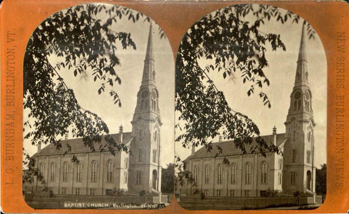
First Baptist Church
This image shows the view of the First Baptist Church at 81 St. Paul Street in Burlington, looking northwest from the corners of College and St. Paul Streets. The church is three bays wide by six bays deep, with a large rectangular massing. It has the shape of Wren Gibbs church, with a large tower in the front separated from the rectangular auditorium form behind it. The building was originally clad in wood, and has since been covered in brick. The landmark spire is sheathed with copper, giving it its green tint.
This image shows the view of the First Baptist Church at 81 St. Paul Street in Burlington, looking northwest from the corners of College and St. Paul Streets. The church is three bays wide by six bays deep, with a large rectangular massing. It has the shape of Wren Gibbs church, with a large tower in the front separated from the rectangular auditorium form behind it. The building was originally clad in wood, and has since been covered in brick. The landmark spire is sheathed with copper, giving it its green tint.
The structure was built in the Italianate style in 18641 for $32,500, mostly paid for by Lawrence Barnes, a lumber baron in Burlington and a parishioner.2 It was dedicated that same year.3 The church appears on the 1869 Sanborn map described as “Baptist Church.”4 In 1906, the church begins being referred to as “First Baptist Church,” on the Sanborn maps. There was a large addition to the rear of the building in 18715, costing $23,000.6
The twentieth century also saw some major changes to the building. In 1905, the wood exterior of the building was bricked, and stained glass windows were installed. In 1986, there was an addition of an elevator shaft located in the north side of the church. In 2001, the building was listed on the National Register of Historic Places.7
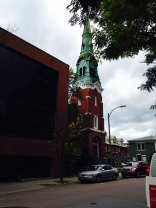
Today, the First Baptist Church looks much like it did in 1864 aside from the brick veneer and stained glass windows. However, the setting of the building has changed immensely. The building is no longer seen in its entirety from the viewpoint of the original photo, given that a restaurant abutting the church to the south blocks much of the view.
St. Paul Street
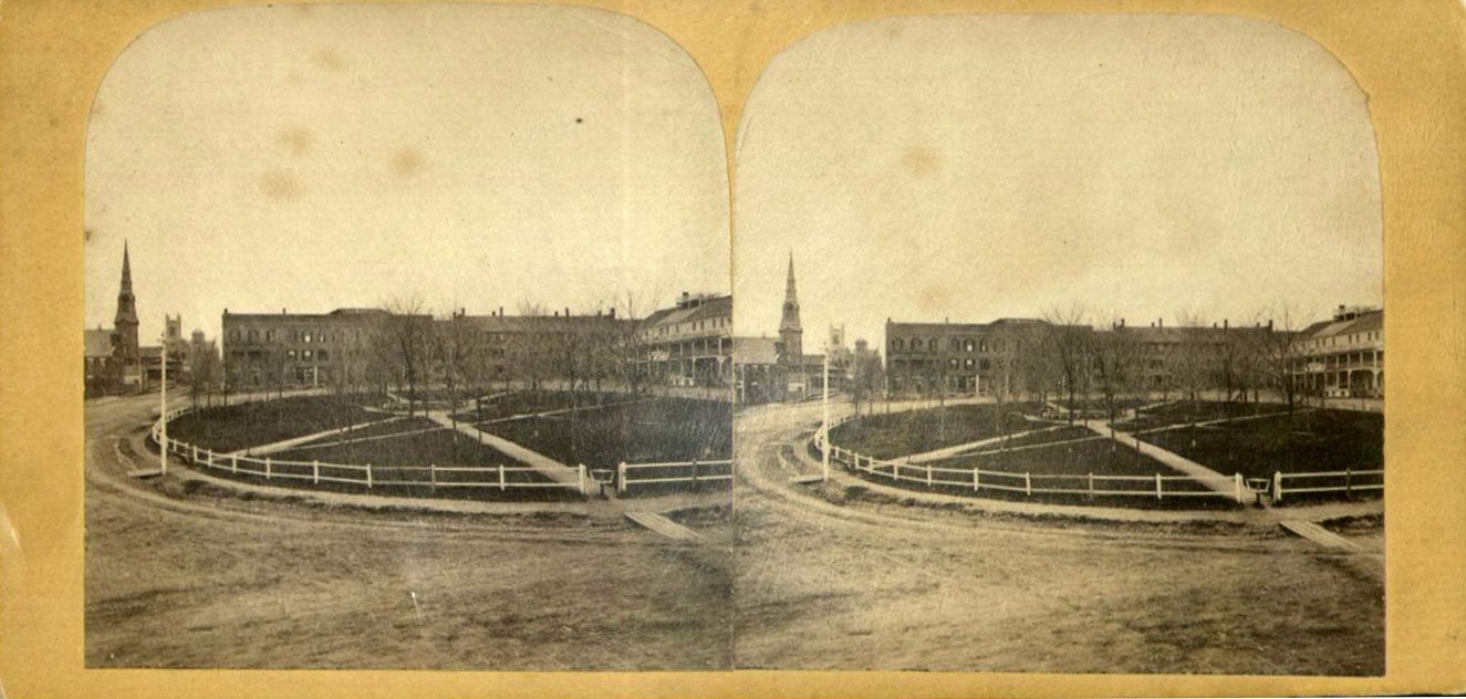
This image of St. Paul Street looking north was taken after the year 1889. The photographer was standing at about the midpoint of City Hall Park. All the buildings first appear as they shown on the Sanborn Fire Insurance Maps in 1894. The home in the immediate foreground on the left side of the image first appears on the Sanborn Fire Insurance maps in 1869. At this point, it was an unmarked building, and its use was not designated on the map in any way.8 By 1885, this building is marked “Dw’g,”9 indicating that it was a private home.10 This classification remained until the 1894 map that showed all the buildings in the image, and identified this building as “offs,” indicating that at this point it was used for offices.11
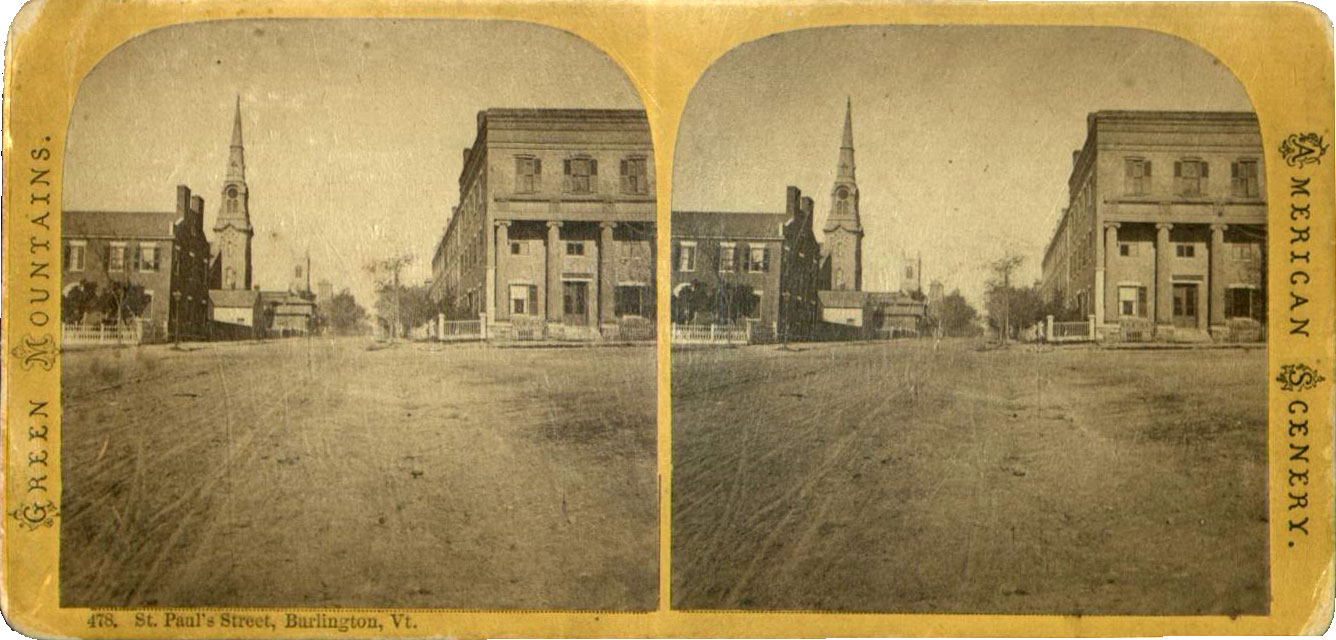
The building on the left, protruding between the building in the immediate foreground and the church first appeared on the Sanborn maps in 1894. This building served as a carriage house for the stable that was located directly to the west of it. This stable, unseen in the image, first appeared on the Sanborn Maps in 1869.12
To the north of the carriage house is the First Baptist Church. This building first appeared on the Sanborn maps in 1869. The building north of the First Baptist Church also first appeared on the Sanborn maps in 1869. It appeared on this map as a “Dw’g,” indicating that it was a private residence. It remained a private residence until the 1894 map. The building in the background of the left side is the Episcopal Church. This building first appeared on the Sanborn maps in 1869. There was an addition added on to the church in 1885.13
On the right side of the photo, the building in the immediate foreground first appeared on the Sanborn maps in 1869. At this point in time, the building was used for a “cloth store,” a dwelling and a bank. In 1885, the building was only used as a private home and a bank. It remains this way until the 1894 map.
Today, the Episcopal Church no longer stands, as it was destroyed by fire in 197114. The First Baptist Church is obscured by the Vermont Pub & Brewery building, located where the family home and carriage house was in the original image. Citizen’s Bank occupies the footprint of the building on the right side that historically housed tenements and the bank.
Old Customs House
This image illustrates the building at 175 Main Street in Burlington, looking south from Main Street, between Church Street and South Winooski Ave. The building in this image was the first of two custom houses at this location in Burlington. The building was constructed from brick, and was a rectangular block that was three bays wide by five bays deep. The picture was taken after the year 185715 when the structure was built and before 1903, when ground broke for a new custom house building that opened in 1907. Pictured in this stereograph is a hitching post on the far right side of the image, and a horse drawn passenger carriage.
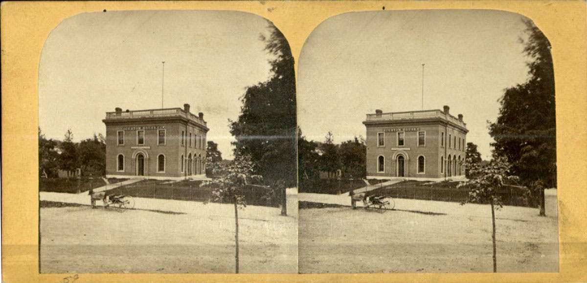
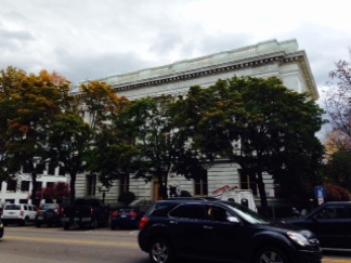
The new building served as the post office and custom house until 1960 when a new building was built on the corner of Elmwood Avenue and Pearl Street. From 1963-1974, it served as an army reserve center.16 The structure is today the Chittenden County Superior Courthouse, a role it has assumed since 1974.
Old Courthouse
This image, looking southeast on Church Street, is of the building formerly located at 180 Church Street in Burlington, Vermont. In the foreground of the image are hitching posts and a gas lamppost. It was the former court house. The building, completed in 1870 was designed by architect E.C. Ryer in the Second Empire style17 with Alfred B. Mullett as the supervising architect18 is the U.S. Post Office and Court House, and functioned as the U.S. District Court for the District of Vermont. It assumed this function until 1912 when this court was abolished.19 However, in 1919 the building is still labeled on the Sanborn maps as “Court Ho.,” indicating that it was still being used as a courthouse at this time. The map further reads “County Offs 1st,” indicating that county offices were located on the first floor of the building.20
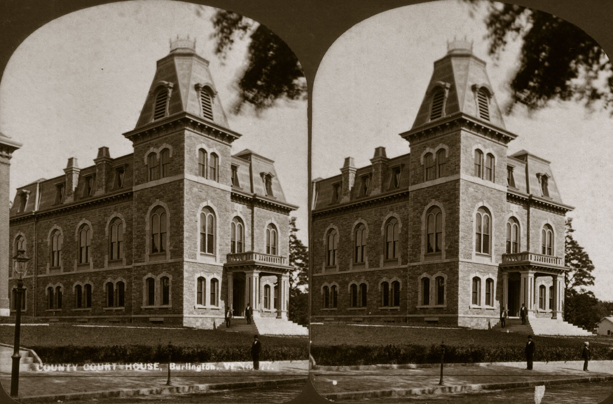
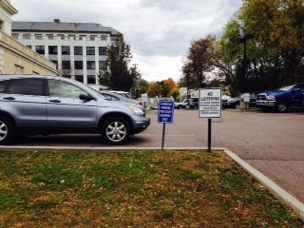
In 1973, the old court house building was listed on the National Register of Historic Places. The next year in 1974, the U.S. government donated the new (1907) Custom House to Chittenden County for use as a county courthouse.21 The old courthouse building subsequently burned and was demolished shortly after in 1982.22 At the time of the fire, there were still court documents being stored in the basement of the building.23The site now serves as a parking lot.
Van Ness House
This image depicts the Van Ness House, looking south west from the northeast corner of Main Street and St. Paul Street. This building occupied the southwestern corner of Main Street and St. Paul Street. Today, T.D. Bank occupies this location. The Van Ness House was a hotel that was built in 1871 by Messrs. Barber and Ferguson.24 Barber was the son of one of the first residents of Richmond, Vermont. Prior to becoming the construction of the Van Ness House, the Howard House Hotel, of which Barber was proprietor, stood in its place until 1863 when it was destroyed by fire. In 1881, the building was sold to Vermont Governor Urban Woodbury in a foreclosure sale through Burlington Savings Bank. At the time of the sale, the Van Ness House had 50 feet of street frontage of Main Street and 125 of St. Paul Street. In 1883, there was an addition to the building that added a west wing, adding 75 feet of street frontage on Main Street. Barber retired and spent his time working in a small livery stable behind the hotel.25
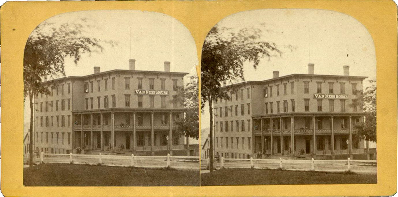
Historically, the Van Ness House was politically important building. Governor Woodbury, who also was proprietor of the American House hotel across the street, operated the two buildings as one unit that quickly became a hot spot for meetings and social gatherings. It has been said that Woodbury was able to use connections he made here to gain political clout, as well as to gauge the climate of Vermont politics.26 The above stereograph image was taken sometime after the addition was added to the original structure. 27
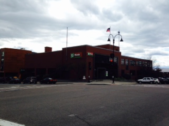
In 1951, the Van Ness House burned. In 1957, the Howard Bank built a new structure in the place of the burned Van Ness House at the southwest corner of Main Street and Saint Paul Street.28 In 1996, Howard Bank merged with the Toronto-Dominion Bank (TD Bank), known as Banknorth Group Inc. at the time. Today, the building is still occupied by TD Bank.
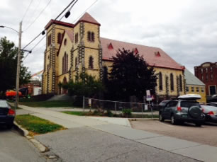
College Street Congregational Church
The College Street Congregational Church is located at 265 College Street in Burlington, Vermont. The image is taken looking southeast on College Street from the corner of College Street and South Winooski Avenue. The congregation that attended services at this church was established by 45 members that formerly attended the First Congregational Church and seven other members in 1860. They decided to call it the Third Congregational Society.29
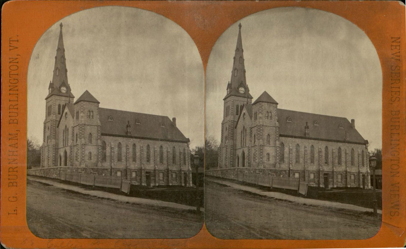
The construction for the congregation’s new church, the College Street Congregational Church, began on this location in 1863. The building used yellow sandstone quarried at Willard’s Ledge on Shelburne Road for the main block of the building, and blue limestone trim from quarries in Isle La Motte.30 According to David Blow’s Historic Guide to Burlington Neighborhoods , the land on which the Gothic Revival style church stands was purchased by the Third Congregational Society in December 1862 for three hundred dollars.31 The church was nominated for placement on the National Register of Historic Places in 1977.32
Over the past 20 years, arson has hit this iconic Burlington church not once, but twice. In 1994, an arsonist did roughly $200,000 dollars worth of damage to the property.33 The more serious of the incidents occurred on October 23, 2013, and resulted in the loss of the spire of the church’s 114-foot steeple. As of 2014, the church is planning a reconstruction project of the steeple.34
Rowe's Hotel
The building in this image is Rowe’s Hotel, located on the southwest corner of Church and Cherry Streets. The viewpoint of the image is from about #42 Church Street, looking toward the northwest. The origins of Rowe’s Hotel are ambiguous. The building was certainly constructed prior to 1830, as a structure in this location and orientation is seen on Ammi Burnham Young’s Plan of Burlington Village.35 According to William S. Rann’s 1886 History of Chittenden County, Vermont: With Illustrations and Biographical Sketches of Some of Its Prominent Men and Pioneers, the hotel may have been built prior to 1800 by Harvey Durkee.36
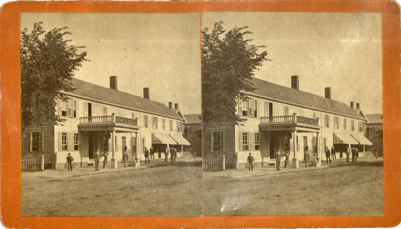
This photo was taken between 1874 and 1884, after the title was transferred to the son-in-law of the proprietor of the Stanford House, the hotel and saloon that occupied the building prior, and before it appeared in the city directories as Hotel Chittenden.37 The “Rowe’s Hotel” label remained on the building on the Sanborn Insurance maps until 1900, when the building’s name was changed to “Sherwood Hotel.”38 Interestingly, the building is listed as Hotel Chittenden in city directories from 1889-1892; changing to Sherwood Hotel in 1894.
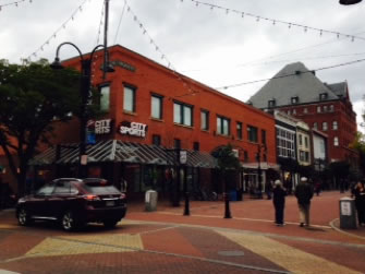
In 1912, this structure was demolished and a new structure for the Sherwood Hotel was built. In 1928, JC Penney department store became the proprietor of the building until 1937 when Sears & Roebuck Company bought the building. In 1940, the building burned.39 Today, City Sports is located at the site.
Payn's Block
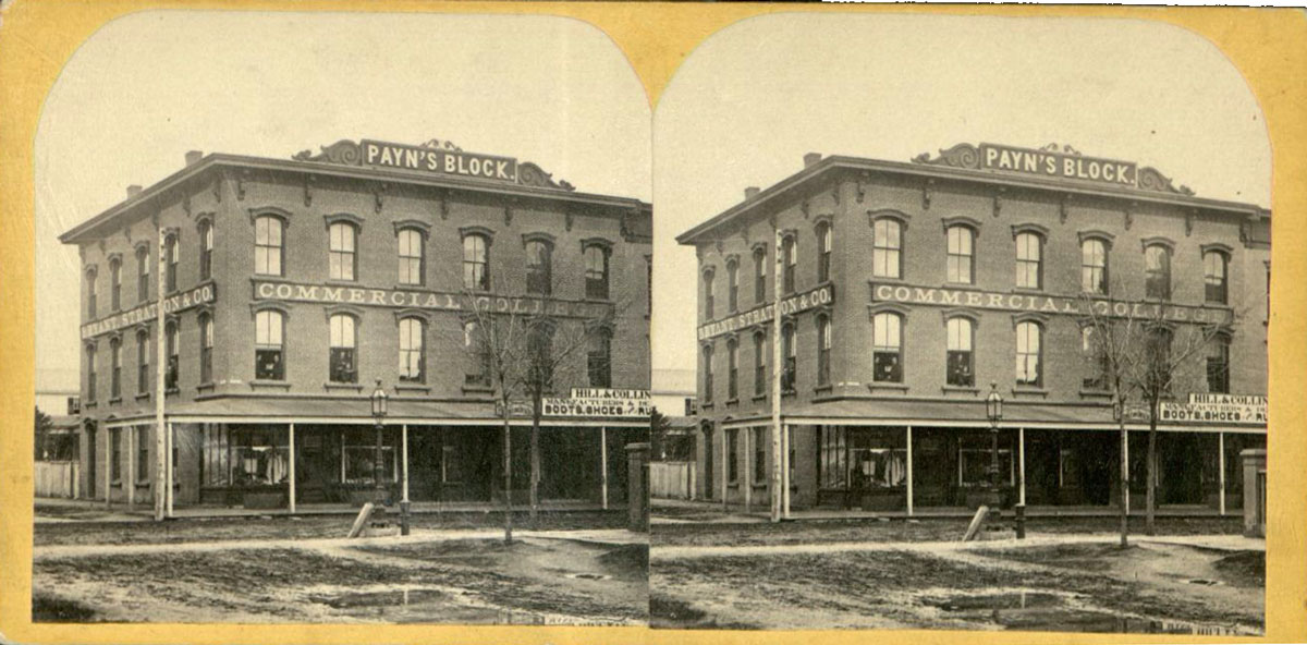
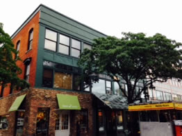
Payn’s Block is located on Church Street in Burlington, Vermont. This view is looking southeast toward Payn’s Block from #35 Church Street. It was built in 1865 for a Burlington gunsmith and locksmith who worked in the building and lived in an apartment on the upper level.40 The sign on the left side of the building reads “Bryant & Stratton Co.” The large sign at the top of the front of the building reads “Payn’s Block,” with the sign directly below it reading “Commercial College.” The sign for the business in the lower right hand corner of the image reads “Hills & Collin Manufacturers and Desend of image, Boots, Shoes and Ru.” This building first appeared on the Sanborn Fire Insurance Maps in 1869, at which point the building was occupied by two “mill’ries” and a “gro,” indicating a grocery store and two markets in the building.41 In the 1885 map, the building was occupied by “Crockery Wallpaper,” “Glass Crockery,” and “Milly Fancy.”42 Throughout the years, Payn’s Block remained largely a commercial building. Through the 1870s, it was occupied by P.D. Ballou’s, Burlington’s third mayor’s, bookstore. The 1890s saw uses of the building including a sewing machine store, general store, a clothing retailer and crockery.43 Today, the building is occupied by Dear Lucy clothing shop and Uncommon Grounds coffee shop on the first floor, and by apartments on the upper level.
City Hall Park
This image shows City Hall Park looking northeast from the corner of Main Street and St. Paul Street in the year 1874 or 1875. The park is located behind the City Hall Building on Church Street, and is encased by St. Paul Street, Church Street, Main Street and College Street. The land for the park was granted by Benning Wentworth, the Royal Governor of New Hampshire in 1763 for use as a “town plot.” By 1794, the land was being used as a public common and in 1798 it was officially referred to at a Burlington Proprietor’s Meeting as a “public park”.44 This picture was taken in 1874 or 1875, as a carriage way was constructed in this year to allow people to pass through the park on wagons without ruining the landscaping of the park, and in 1875, there was a change in the arrangement of the park from an oval to rectangular orientation.45,46 A fountain was donated to the park in 1881 by John Purple Howard.47
In 1975, there was a project undertaken to rejuvenate City Hall Park. A reflecting pool replaced the original fountain dedicated on the Fourth of July 1976, designed by Burlington architect William Wiese. The park was renovated again in 1993-1994 with the most notable improvement being the installment of a 1905 granite fountain, formerly located on College Street, in the center of the park.48 Today, there are trees located in the green space, obscuring the view of St. Paul Street in the background.
Notes
1. "First Baptist Church: Burlington,” Nomination for the National Register of Historic Places, 2001. Accessed at http://www.burlingtonvt.gov/docs/5009.pdf; David Blow, Historic Guide to Burlington Neighborhoods Vol. 3. (Burlington: Chittenden County Historical Society, 2003), 121.
2. David Blow, Historic Guide to Burlington Neighborhoods, Vol. 3. (Burlington: Chittenden County Historical Society, 2003) 121.
3. First Baptist Church (Burlington, Vt.) Records, Special Collections, University of Vermont Library.
4. Sanborn Fire Insurance Maps, University of Vermont Libraries’ Center for Digital Initiatives.
5. National Park Service. “First Baptist Church: Burlington,” National Register Form.
6. Blow, 121.
7. Blow, 121.
8. Sanborn Insurance Map. UVM Libraries Center for Digital Initiatives.
9. Sanborn Insurance Map, 1885. UVM Libraries Center for Digital Initiatives.
10. “Guide to Sanborn Fire Insurance Maps,” accessed at Mississippi State University Libraries: Special Collections Digital.
11. Sanborn Insurance Map, 1894. UVM Libraries Center for Digital Initiatives.
12. Sanborn Insurance Map, 1869. UVM Libraries Center for Digital Initiatives.
13. Sanborn Insurance Map, 1885. UVM Libraries Center for Digital Initiatives.
14. “About St. Paul’s Cathedral.” Home. Accessed October 17, 2014. www.stpaulscathedralvt.org.
15. Abby Marie Hemenway, ed., “Burlington,” Vermont Historical Gazeteer, (Burlington, Vt.: A.M. Hemenway, 1867).
16. Blow, 193
17. Blow, 194
18. “History of the Federal Judiciary.” Federal Judiciary Center. Accessed October 10, 2014.
19. Ibid.
20. Sanborn Insurance Map, 1919. UVM Libraries Center for Digital Initiatives.
21. Connie Cain Ramsey, “VT Courthouse History: From a Tavern to Marble Halls,” accessed at www.burlingtonfreepress.com
22. “Chittenden Co. Courthouse,” National Register Nomination Form.
23. Blow, 194.
24. Chas R. Cummings. “The Vermonter.”
25. Blow, 76
26. Blow, 76.
27. Robinson
28. “Modern Architecture Survey, Burlington, Vermont.” City of Burlington, Vermont. Accessed at www.burlingtonvt.gov.
29. Blow, 20.
30. Blow, 21.
31. Blow, 21.
32. “College Street Historic District,” National Register Nomination Form, 1977.
33. “Arson Suspect Arrested in Burlington Church Fire.” WCAX, accessed at wcax.com.
34. “Burlington, Vermont.” City of Burlington Board of Finance Request Summary.
35. A. B. Young. “Plan of Burlington Village,” 1830. UVM Special Collections.
36. W. S. Rann, History of Chittenden County, Vermont, with illustrations and biographical sketches of some of its prominent men and pioneers. (Syracuse, N.Y.: D. Mason & Co., 1886).
37. Burlington City Directory. Burlington, Vermont, 1889.
38. Sanborn Fire Insurance Maps, 1900. UVM Libraries Center for Digital Initiatives.
39. Blow, 148.
40. “Church Street.” National Register Nomination Form
41. Sanborn Fire Insurance Maps, 1869. UVM Libraries Center for Digital Initiatives.
42. Sanborn Fire Insurance Maps, 1885. UVM Libraries Center for Digital Initiatives.
43. “Church Street.” National Register Nomination Form.
44. Blow, 44.
45. Blow, 47.
46. City of Burlington, Eleventh Annual Report of the City Government for the City of Burlington, Vermont for the year ending December 31, 1881 (Burlington, VT: Free Press Book and Job Printing House, 1882), 82.
47. City of Burlington, Seventeenth Annual Report of the City Government for the City of Burlington, Vermont for the year ending December 31, 1881 (Burlington, VT: Free Press Printing, 1882), 43.
48. Blow, 48.