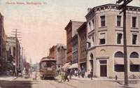
Photo taken from 131 Main Street pre-1910, looking north. Postcard courtesy of Special Collections, UVM Bailey-Howe Library.
Photo taken from 131 Main Street looking north on October 18, 2012. Photographed by Suzanne Mantegna.
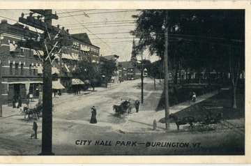
There are several changes to the streetscape visible looking north from 131 Main Street (Vermont House/Hotel Vermont). Now cars and parking for cars, instead of horse and buggies or streetcars, line the streets. There are crosswalks for pedestrians and traffic signals today, but the town of Burlington in 1910 would not have needed such things. The population in Burlington in 1906 was 22,000(1); today the population is almost twice that number- 42,417.(2) In the pre-1910 postcard, power lines and telephone poles were running up both Main and St. Paul Streets. Today the power lines have been moved underground and only the newly installed street lamps take the telephone poles' place. The buildings have changed remarkably little in the intervening century. The Woodbury-Walker building looks the same and the adjacent building, the former Hotel Burlington, is only three stories instead of four due to the fire of January 8, 1910. The next building north is now the biggest on the block and is home to American Flatbread. Then the following building is the same Italianate building from the postcard. According to David Blow in the Historic Guide to Burlington Neighborhoods, Volume III, the original building was built in 1807 and was a three-story brick building. The fourth floor and Italianate finishes were added in 1870.(3) Further north on St. Paul, the only modern building, home to The Vermont Pub & Brewery, blocks the view of the most of the First Baptist Church, but the spire is still visible. City Hall Park appears relatively unchanged, except for the addition of the sculpture in the foreground.
1. Sanborn Insurance Maps of Burlington, Vermont (Sanborn Map Company, March 1906), sheets 22-3, 26-8.
2. Wolfram/Alpha. Accessed October 29, 2012, http://www.wolframalpha.com/input/?i=population+burlington+vt.
3. David J. Blow, Historic Guide to Burlington Neighborhoods, vol. 3 (Burlington, VT: Chittenden County Historical Society, 2003), 122.