
|
|
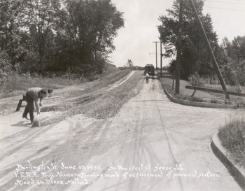
Date: June 13, 1935 |
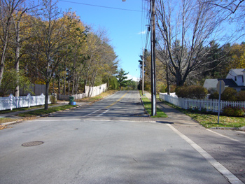
Date: October, 2006 |
Looking East On Ledge Road |
Geographic Position: 180642967E 492417N |
Immediately beyond the horizon, a sharp left turn merges Ledge Road into South Prospect Street. The sharp turn did not escape the attention of Burlington’s Street Department; the Street Department deemed it a hazard, especially in inclement weather. According to the Report of the Street Commissioners for Burlington in 1931, “Ledge Road for several years has been dangerous for traffic when the surface was wet and although no serious accidents had happened, it was necessary to have signs warning the public of this condition…several minor accidents have happened each year.”[1] Emulsified Asphalt was applied to alleviate the problem.[2] In 1935, new sewers were constructed and pavement surfaces replaced utilizing the mixed-in-place method. The mixed-in-place method, as the name indicates, consists of crushed stone (visible in the photograph) mixed-in-place with asphalt binder; moderately warm, dry weather is ideal for this process. The project cost a total of $29, 929.97 with a total of $21, 438.45 allocated for labor via V.E.R.A.[3] A close look at the photograph reveals the following: “V.E.R.A. Proj. No. 402-B-7-10.” V.E.R.A. is one of the numerous federal employment projects aimed at combating unemployment during the Great Depression.[4] According to the 1934 Annual Report of Burlington, “The Street Department has fallen, in a large measure, the responsibility during the past year, of carrying on various projects aimed to relieve unemployment.”[5] The excess responsibility admittedly put a strain on the department’s time and resources, which the annual report discussed in detail.[6] Immediately beyond the right-hand side of the photograph rests a home located at 151 Ledge Road. The immediate surrounding area is not visible on the 1936 Sanburn Insurance Map of Burlington, VT. However, the building is visible on the 1942 version of the map. In 1936, a likely construction date, the Burlington City Directory contains the first reference to 151 Ledge Road; Arthur E. Dietrich, a sales manager at E. S. Adsit Coal Company, is registered to the home.[7]
[1] City of Burlington, Vermont, Sixty-eighth Annual Report of the City of Burlington, Vermont: For the Year Ended December 31, 1932 (Burlington, VT: Lane Press Inc, 1932) , 224. [2] Ibid. [3] City of Burlington, Vermont, Seventy-first Annual Report of the City of Burlington, Vermont: For the Year and One-half ended June 30 (Burlington, VT: Free Press Printing Co., 1936) 298. [4] William W. Bremer, “Along the ‘American Way’: The New Deal’s Work Relief Programs for the Unemployed,” The Journal of American History 42, no. 3. (1975): 636. [5] City of Burlington, Vermont, Seventy-first Annual Report of the City of Burlington, Vermont: For the Year and One-half ended June 30 (Burlington, VT: Free Press Printing Co., 1936), 298. [6] Ibid, 153. [7] Burlington City Directory (Springfield, MA: H.A. Manning Company, 1936), 66, 206. |
The landscape remains fundamentally similar. The home at 151 Ledge Road is still present and has since added an addition similar in style to the original building. White fences placed neatly behind concrete sidewalks are now visible. New crosswalks can also be seen crossing Hillcrest Road and Ledge Road. Power lines remain in the same approximate location and are still absent from the left-hand side. |
Historic Burlington Project Depression Era Streetscapes: Old North End | Burlington 1890 | Burlington 1877 | Burlington 1869 | Burlington 1853 | Burlington 1830 Produced by University of Vermont Historic Preservation Program graduate students in HP 206 Researching Historic Structures and Sites - Prof. Thomas Visser - in collaboration with UVM Landscape Change Program Historic images courtesy of University of Vermont Library Special Collections, Louis L. McAllister Photograph Collection |