
|
|
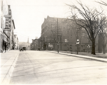
Date: c. 1929 |
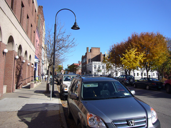
Date: October, 2006 |
Looking East On College Street |
Geographic Position: 180642040E 4926425N |
This photograph shows the completed reconstruction of College Street near the intersection of St. Paul Street. The project accomplished three things: new asphalt pavement, concrete sidewalks and a new O.G. curb. A total of 1,400 linear feet of sidewalks and 1,374 linear feet of curbing were installed on College Street from South Winooski Avenue to St. Paul Street.[1] 1924 marked the first year that Burlington attempted to do the road work in-house and not contracted privately. Burlington decided for this change in an attempt to save money and provide a significant amount of employment.[2] Understandably, the process was not without its difficulties. According to the 1924 Annual Report of Burlington: “The operation of the street laying gang was not what we hope it will be in the course of another season or so. There is considerable difference in breaking in men for day labor wok as against acquired experience men who make asphalt paving a business. The raking and rolling- two features of highest importance- were handicapped this year.”[3] The large building on the right-hand side of the photograph is the old YMCA building. The building was constructed in 1887-1888 jointly by S. Huntington and the YMCA, but, unfortunately, the vast majority of building was destroyed by fire- the cause was unknown- on February 1, 1928.[4] YMCA shared the building with Bailey’s Music rooms of Burlington, M.D. William M. Townsend and the Prudential Insurance Company of America.[5] Visible in the foreground are two large signs for the E. S. Adsit Coal Company and B. Turk & Brothers Clothing Company housed at 154 College Street and 156/158 College Street, respectively. The three story roof line for the structures runs interrupted from the Old Burlington Savings Bank to the four-story redstone structure at 162 College Street.
[1] City of Burlington, Vermont, Sixty-fifth Annual Report of the City of Burlington, Vermont: For the Year Ended December 31, 1924 (Burlington, VT: Free Printing Press, 1924), 158. [2] Ibid, 16. [3] Ibid, 162. [4] City of Burlington, Vermont, Sixty-fifth Annual Report of the City of Burlington, Vermont: For the Year Ended December 31, 1929 (Burlington, VT: Lane Press Inch, 1929), 260. [5] Burlington City Directory (Burlington, VT: Free Press Printers, 1924), 344. |
Along the left-hand side of the photograph, the large brick and corrugate concrete structure with a series of first-floor arches is visible. The structure was an addition of the Burlington Savings Bank, which is currently Citizen’s Bank, designed by Stainton, Cowles and Hapgood; it replaced 152, 154 and 156-158 College Street.[1] A remnant of the old three-story roof line for the structures that ran interrupted from the Old Savings Bank to the four-story red-stone structure at 162 College Street is visible. The third-floor remnants of the pink Northfield Savings Bank building (160 College Street) can be seen on its surviving redstone neighbor at 162 College Street. On the right-hand side of the photograph, the absence of the old YMCA building is strikingly evident. On February 1, 1928, a fire of unknown cause destroyed the majority of the building. The first-floor was salvaged by the original co-constructor, S. Huntingdon, and a new three story addition designed by Frank Austin was constructed.[2] The first-floor is now the site of the men’s clothing store Michael Kehoe. The large white structure is the Chittenden County Trust Company building. The stone exterior is in actuality a veneer over the underlying load-bearing brick masonry.[3] The building is constructed in an “L” shape and extends onto Church Street. The smaller, two-story section of the building is currently owned by the cleverly named restaurant “Anything’s Pastable”. The large, bare American elm trees have since disappeared and have been replaced by smaller, more manageable trees. Most likely due to urban zoning restrictions, the powerlines have since been placed underground. New streetlights and the ubiquitous parking meters are also now visible.
[1] David J. Blow, Historical Guide to Burlington Neighborhoods: Volume II, ed. Lilian Baker Carlisle (Burlington, VT: Queen City Printers Inc., 1997), 41. [2] Vermont Division for Historic Preservation, Vermont Historic Sites and Structures Survey. Burlington: College Street, 1979. (Found at the University of Vermont Library, Special Collections.) [3] Ibid. |
Historic Burlington Project Depression Era Streetscapes: Old North End | Burlington 1890 | Burlington 1877 | Burlington 1869 | Burlington 1853 | Burlington 1830 Produced by University of Vermont Historic Preservation Program graduate students in HP 206 Researching Historic Structures and Sites - Prof. Thomas Visser - in collaboration with UVM Landscape Change Program Historic images courtesy of University of Vermont Library Special Collections, Louis L. McAllister Photograph Collection |