
|
 |
 |
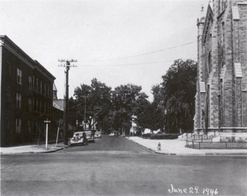
84 Cherry Street Taken at the intersection of Cherry Street and St. Paul Street looking west down Cherry Street, this McAllister photograph depicts how the west half of downtown Burlington looked in 1946. Bordering the downtown business district and adjacent residential area to the west, this area is a transition zone between commercial and residential uses. The more residential areas are characterized by large overstory deciduous trees seen in the background of the photograph, while the more commercial areas have limited or no trees like in the foreground. Cherry Street is narrower than other adjacent streets, with two through lanes and on-street parking along the south side of the street. Three cars are parked along the cut stone curb to the south side of the street. The street corners are characterized by a utility pole that supports overhead utility lines, a street sign, and a fire hydrant. To the south (left) is a brick building, 35 St. Paul Street, and along the north (right) side of the street is the Cathedral of Immaculate Conception, 97 Cherry Street. The Cathedral has a low iron railing surrounding the lawn area in the foreground, while a low hedge marks the property to the west in the background. The caption on the photograph reads, “This view of Cherry Street taken from the intersection of St. Paul Street shows the new stone-filled sheet asphalt hot plant mix pavement in front of the Cathedral Church only a few days after its completion. This pavement was constructed approximately two inches in thickness over the old pavement as a base. The gutters were first built up to maintain a uniform depth of six inch curb face.” 35 ST. PAUL STREET The building at 35 St. Paul Street is a three story, five bay wood frame building with a brick veneer. The building first appears on the 1853 map of Burlington, indicating it was constructed during the mid 19th century(1). By 1869, J.W. Carpenter owned the property, and after the turn of the century in 1901, the building remained occupied by a single tenant—W.N. Perry(2). However, by 1931, the building was subdivided into apartments and offices. Tenants included Yvonne N Turk, physician, David Manson, dentist, Harry T. Bason, Leonard Johonnott, and Irene Wadsworth(3). One apartment was also listed as vacant at the time. In 1942, the building continued to house a number of occupants including Erald F. Foster, physician, David Manson, dentist, Thomas O’Halloran, Mrs. Edyth D. Bushnell, Leonard Johonnott, and Raymond McKenzie(4). 97 CHERRY STREET The Cathedral of the Immaculate Conception is a Gothic Revival church constructed of local materials including marble and slate from the Rutland area, limestone from Isle of la Motte, and redstone from the local Burlington area(5). Sited on the location of the former St. Mary’s Church that was constructed in 1841, the Cathedral was built to replace the St. Mary’s Chruch and accommodate the growing Catholic and immigrant population in Burlington during the late 1860s(6). The building was designed and constructed by Patrick Keeley from Brooklyn beginning in the early 1860s(7). The design called for two separate part of the church—the Cathedral to Immaculate Conception and a smaller chapel to St. Patrick. While the cornerstone for the foundation of the chapel was set on June 10, 1862, the cornerstone for the Cathedral wasn’t set until one year later during the summer of 1863(8). After a lengthy construction process, the Cathedral opened for worship on May 18, 1867, and was consecrated almost six months later on December 8, 1867 as the “first church in the northeast designed, created, and dedicated as a Cathedral Church.”(9) Though the building was opened and utilized by parishioners, the bell tower was not yet completed. Nevertheless, the original bell from the 1841 St. Mary’s Church was placed in the unfinished bell tower while construction on the tower progressed(10). In 1899 the original bell cracked and was replaced with a new bell weighing 4500 pounds one year later(11). In 1904, construction of the bell tower was completed, and the tower was opened(12). Little was done to the church between the early 1900s and 1940s, with the exception of resetting the alter in 1936 after vibrations from adjacent traffic on St. Paul and Cherry Streets caused the alter to sink(13). Back to Depression Era Streetscapes.
(1) Presdee and Edwards Map. Burlington, Vermont 1853. (2) Beers Map of Burlington, Vermont 1869; Burlington City Directory, 1931 (Burlington: H. A. Manning Co., 1916-1986). (3) Burlington City Directory, 1931 (Burlington: H. A. Manning Co., 1916-1986). (4) Burlington City Directory, 1942 (Burlington: H. A. Manning Co., 1916-1986). (5) Heaney, Joe. “The Cathedral is 100 Years Old Today,” Burlington Free Press, Dec 8, 1967. (6) “A Commemorative of the Solemn Liturgy of Dedication of the Cathedral Church of the Immaculate Conception of the Diocese of Burlington, Vermont” May 26, 1977. (7) “A Commemorative of the Solemn Liturgy of Dedication” May 26, 1977. (8) “A Commemorative of the Solemn Liturgy of Dedication” May 26, 1977. (9) “A Commemorative of the Solemn Liturgy of Dedication” May 26, 1977. (10) “A Commemorative of the Solemn Liturgy of Dedication” May 26, 1977. (11) Heaney, Joe. “The Cathedral is 100 Years Old Today,” Burlington Free Press, Dec 8, 1967. (12) “A Commemorative of the Solemn Liturgy of Dedication” May 26, 1977. (13) Heaney, Joe. “The Cathedral is 100 Years Old Today,” Burlington Free Press, Dec 8, 1967. |
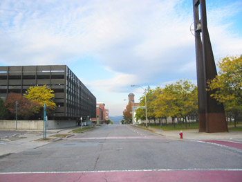
20 Pine Street The appearance of the streetscape at the intersection of Cherry Street and St. Paul has changed, but remains similar to its 1946 appearance through abstract forms. The tall church tower is recalled through a more modern steel bell tower, while the former historic brick commercial block is recalled through the rectangular form of the parking garage across the street. The width of the street remains with two lanes of traffic with on-street parking along the south side. Parking is reserved for loading and unloading zones for Chittenden County Transportation Authority (CCTA) buses. A hydrant remains on the northwest corner (left) though the fixture has been replaced with a more modern and efficient version. Stamped concrete and painted crosswalks are seen at the intersection. One of the most significant changes in the area today is the closing of St. Paul Street to the south. Beginning in 1959, the city of Burlington approved a major urban renewal project to rid of urban blight and unsightly slums west of the downtown business district. As a result, twelve acres of land were razed such as the block south of Cherry Street and three streets were closed, including St. Paul Street to accommodate the urban renewal project(1). Though approved, resistance to the project by residents in the area slowed the acquisition of property and the demolition of structures, but by 1965 demolition had begun(2). Four years later, in 1969, the first of many office buildings were completed(3). Prior to 1979, Burlington Square Mall, now called Burlington Town Center, was constructed along with a 620-space parking garage, both seen on the far left. The mall provides over an additional 150,000 square feet of retail and commercial space in the downtown business district(4). The associated parking garage was designed by the architectural firm of Mies Van der Rohe(5). In 2001 the Burlington Town Center was renovated(6). The Cathedral of Immaculate Conception has also changed drastically. In 1949, the redstone Gothic Revival structure underwent a complete interior renovation in preparation for the 100-year anniversary of the diocese in 1954(7). However, on March 13, 1972, the Cathedral burned. The fire was first report at 11:20 PM and adjacent residences were evacuated(8). Though firefighters tried to contain and control the fire, the church’s bell tower collapsed shortly after midnight, sending the 4500 pound bell to the ground(9). By morning, all that remained of the Cathedral was smoldering ruins. Fortunately, only one firefighter was injured during the battle to control the flames; however, the loss of the Cathedral of the Immaculate Conception marked the eighth major fire in Burlington over a period of thirteen months(10). The nearby St. Paul’s Church, one block south of the Cathedral on St. Paul Street burned only thirteen months earlier(11). In 1973, shortly after the devastating fire, the congregation of the Cathedral of Immaculate Conception decided to rebuild their church. Prominent New York architect Edward Larrabee Barnes was selected to design the new cathedral(12). Barnes is known for his wide range of geometric civic, educational, and ecclesiastical structures that respond heavily to building site and local building materials. His monunmental yet simple structures combine formal order and careful detailing to result in powerful and effective buildings(13). Inspired by H. H. Richardson’s Billings Library at the University of Vermont, Barnes’s design draws upon local references to the library building through the exterior banding of glazed green and dark brown brick, while accommodating the challenges of a declining Catholic population in the community. The new, angular, five-sided church was designed on a smaller-scale to seat 450 people in the sanctuary and oriented on an east-west axis to capture sunlight at sunrise and sunset(14). Barnes collaborated with prominent Vermont-based landscape architect Dan Kiley to design the site(15). Kiley is noted as being one of the most important landscape architects of the 20th century, having worked and studied under notable Warren Manning and later Walter Gropius at the Harvard Graduate School of Design(16). He became of the first modern landscape architects in the country using geometric and ordered forms in landscapes, often collaborating with contemporaries Eero Saarinen and Louis Kahn(17). His works include numerous public spaces, often designing plazas, but despite the popularity of his work during the 1970s, Kiley’s built landscapes are being lost, altered, and redesigned at an alarming rate. Kiley sited the building in the center of the city block reorienting the main entrance to be located off Pine Street, instead of Cherry Street. Kiley also used Barnes’s angular design for the new Cathedral to dictate new circulation patterns and vegetation throughout the site. The building sits within a grove of 123 honey locust trees (Gleditsia triacanthos) that align to the exterior angled façade of the Cathedral, while two sidewalks parallel the trees and criss-cross the site(18). The historic bell was salvaged from the ruins and placed in a free-standing steel belltower at its former location of the corner of Cherry and St. Paul Streets, serving to recall the former Cathedral building that burned. On March 13, 1977, the new Cathedral reopened to parishioners, and was dedicated two months later on May 26, 1977(19). Today the Cathedral and surrounding landscape remain unaltered from their 1970s appearance. However, in June 2006 the city of Burlington approved a feasibility study regarding a new public transportation facility located along St. Paul Street, which would effect the Barnes building and Kiley landscape(20). Since the transportation center is currently in the initial design phase, awareness about the building and landscape are being raised, in hopes of designing a facility that is compatible with the adjacent landscape and minimally obtrusive to the Barnes and Kiley design. Back to Depression Era Streetscapes.
(1) A History of the Church Street Marketplace. www.churchstmarketplace.com/history.html 3 November 2006. (2) A History of the Church Street Marketplace. www.churchstmarketplace.com/history.html 3 November 2006. (3) A History of the Church Street Marketplace. www.churchstmarketplace.com/history.html 3 November 2006. (4) A History of the Church Street Marketplace. www.churchstmarketplace.com/history.html 3 November 2006. (5) Blow, David. Historic Guide to Burlington Neighborhoods, Vol. 1 (Chittenden County Historical Society, 2003); 102-103. (6) Community Economic Development Office, City of Burlington, Vermont. www.cedoburlington.org/ 9 November 2006. (7) "A Commemorative of the Solemn Liturgy of Dedication” May 26, 1977. (8) Hapner, Christopher, “Fire Destroys Catholic Cathedral” Burlington Free Press, March 14, 1972. (9) Hapner, Christopher, “Fire Destroys Catholic Cathedral” Burlington Free Press, March 14, 1972. (10) Hapner, Christopher, “Fire Destroys Catholic Cathedral” Burlington Free Press, March 14, 1972. (11) Hapner, Christopher, “Fire Destroys Catholic Cathedral” Burlington Free Press, March 14, 1972. (12) “A Commemorative of the Solemn Liturgy of Dedication” May 26, 1977. (13) “Architect Edward Larabeee Barnes” http://www.greatbuildings.com/architects/ (14) "A Commemorative of the Solemn Liturgy of Dedication” May 26, 1977. (15)“A New-Richardon Romaneque Cathedral” Edward L Barnes, Architectural Record (January 1979:129-136). (16) “Daniel Urban Kiley” Cultural Landscape Foundation. http://www.tclf.org/pioneers/kiley.htm. 7 November 2006. (17) "Daniel Urban Kiley” Cultural Landscape Foundation. http://www.tclf.org/pioneers/kiley.htm. 7 November 2006. (18) “Daniel Urban Kiley” Cultural Landscape Foundation. http://www.tclf.org/pioneers/kiley.htm. 7 November 2006. (19) “A Commemorative of the Solemn Liturgy of Dedication” May 26, 1977. (20) Colman, Devin. “Landslide: Landscapes at Risk” Cultural Landscape Foundation. http://www.tclf.org/landslide/kiley_burlington.html |
Historic Burlington Project Depression Era Streetscapes: Old North End | Burlington 1890 | Burlington 1877 | Burlington 1869 | Burlington 1853 | Burlington 1830 Produced by University of Vermont Historic Preservation Program graduate students in HP 206 Researching Historic Structures and Sites - Prof. Thomas Visser - in collaboration with UVM Landscape Change Program Historic images courtesy of University of Vermont Library Special Collections, Louis L. McAllister Photograph Collection |