
Burlington, Vermont waterfront from
King Street to Pearl Street and east to St. Paul Street
by Susanna E. Prull
Area History
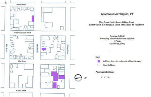
As an economic center, downtown Burlington has undergone numerous changes throughout its history. Throughout the 19th century the city of Burlington flourished thanks to the interstate waterways of Lake Champlain and then later by the new innovative railroad lines. The area stretching north from King Street to Pearl Street and east from the waterfront to St. Paul has been especially affected over the last four decades. Like many cities in the 1970’s, Burlington turned to urban renewal to revive the city’s economy. From the 1890 Hopkins Map one can see that this area was consumed by densely packed blocks of commercial and residential buildings.1 Unfortunately, most of these buildings were destroyed, as can be seen in the 1977 Sanborn Insurance Maps, to make way for the Radisson Hotel, Chittenden Trust Company, the Burlington Square Mall, and other modern office and commercial buildings. Due to this urban renewal of downtown Burlington few buildings built between 1877 and 1890 survive today.2
1. G. M. Hopkins, C.E., Map of the City of Burlington Vermont From official Records, Private plans and
Actual Surveys (Philadelphia: Hopkins, 1890).
2. Sanborn Insurance Map, Burlington, Vermont. Including: Winooski and Parts of the Towns of Colchester, Shelburne and South Burlington. (Pelham, NY: Sanborn Map Company, Inc., 1978).