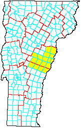
The VMBA Vermont Upper Valley Region Class 4 Road Project assessed most of the class 4 - 7 roads in 17 towns in a region of Vermont (shown in yellow on the adjacent map) bounded on the east by the "Upper Valley" of the Connecticut River. The purpose was to determine which roads are suitable for mountain biking. The assessments were done in 2000 and 2001. The results will eventually be available in a printed 36 inch x 38 inch map available at no charge from VMBA or participating bike shops. Meanwhile, you can also access much of the information from this web page. This includes downloadable Adobe PDF for the map, instructions for use of the map, and the road assessments.
Before downloading any PDF, read Adobe PDF Tips. The 36 inch x 38 inch map PDF is very big (over 5 Meg), so be sure to read these tips.
Right click here and use Save Target As to download Adobe PDF for the whole 36 inch x 38 inch map.
Click here to select and download Adobe PDF for 8.5 inch x 11 inch pages. The 36 inch x 38 inch map PDF has been sliced into a grid of 30 pages. There are three additional pages: one for the map legend, one for the locator map that shows Vermont Upper Valley Region relative to the entire state, and one that shows the index of pages within the grid. Each of these 33 pages fits easily on letter size paper and can be printed from Adobe Acrobat Reader on your color printer. After clicking the link above, you will see a selector map with a page grid. Right click a page in the grid and use Save Target As to download the PDF for that page. To display the selector map, your browser must support PNG format. If you cannot see the selector map, please upgrade to a modern browser that supports PNG.
You can view the text from the back side of the map. This includes instructions for use of the map, and the road assessments.