« BACK
Stories & Galleries
“Intervale Out Loud”
A Sound Map by Kate Blofson
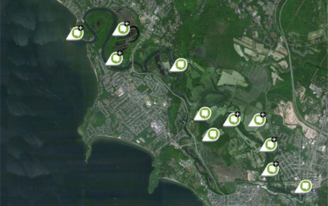
Click image to open sound map. Or try some of the thumbnail images on the right for the interview pieces.
» Or go to this sound map on placestories.com
This oral history project by Kate Blofson focuses on the lower Winooski intervale and is drawn from interviews conducted with farmers, hunters, fishermen, ecologists, and professionals about the Intervale's natural and cultural history.
From Kate Blofson: I call this a place-based oral history project; it focuses on people's relationships with the intervale, how they use it, what it means to them, how it has changed, and why they value it. From different perspectives, stories reveal the connections between the natural history "layers" of the landscape: the river, flooding, soils, plant communities, wildlife, and human history.
For many in the Burlington area and beyond, the term “intervale” is synonymous with the Burlington Intervale (the “Intervale”), a unique urban-agricultural-wild tract of land commonly associated with the Intervale Center. The Burlington Intervale land is within Burlington city limits and encompasses 700 acres of wetlands, agricultural fields, and narrow bands of riparian floodplain forest on the Burlington side of the Winooski River where it passes through the cities of Burlington, Colchester, and Winooski. However, the term “intervale” refers to a rich geographical concept, the floodplain river valleys in New England that the Native Algonquin Abenaki people called wolhanak and European settlers called “intervals,” or “intervales,” long valued for their agricultural productivity.