

Overview
CEE faculty and student research in advanced computational methods in water resources management addresses key needs in numerical methods, optimization, Bayesian techniques, and machine learning and deep learning algorithm development.
Highlighted Research Projects & Initiatives
Groundwater and Subsurface Characterization
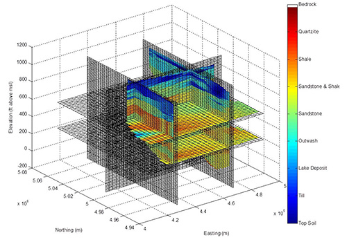 Of the fresh water available for use worldwide, 96% of it is groundwater. Protection and careful stewarding of this valuable resource requires the ability to predict its behavior – where, when, and how it flows through the subsurface. Such predictions are achieved using advanced computational modeling; however, the difficulty and cost associated with obtaining data used to develop groundwater models results in an unavoidable uncertainty in the mathematical representation of the subsurface environment. CEE researchers study how groundwater model forecasts can represent this uncertainty and provide the decision-maker with uncertainty estimates of predicted groundwater behavior, one of the key elements in the assessment of risk. Development and application of this exceedingly important modeling capability is a focus of the groundwater research activity at UVM.
CEE Faculty: George Pinder, Donna Rizzo
Multi-Objective Optimization to Examine Tradeoffs in River Reconnection Projects
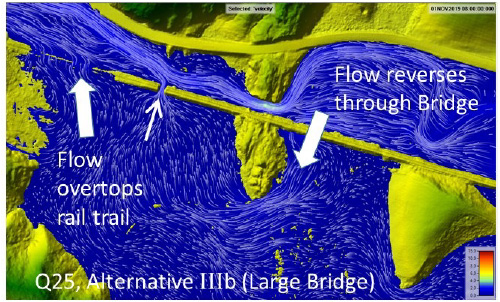 Floodplain and river reconnection projects show great promise to restore water quality, improve flood resilience and enhance habitats. However, with the exponential availability of environmental sensors and associated information, resource managers and planners need decision-support tools to help identify the more effective locations and techniques for floodplain reconnection. Our team is developing multi-objective optimization algorithms to assess multiple stakeholder criteria that prioritize suites of restoration or conservation projects at river network and basin scales. These algorithms may be wrapped around existing hydraulic models (2D HEC-RAS, HAND) or databases (VTANR stream geomorphic data sets) to evolve solutions that optimally meet flood resiliency and water quality goals while simultaneously addressing stakeholder needs. This research is being advanced under several projects supported by the VT Agency of Transportation, VT Department of Environmental Conservation, Lake Champlain Sea Grant, Lake Champlain Basin Program, and the VT Water Resources & Lake Studies Center.
CEE Faculty: Kristen Underwood, Donna Rizzo, Mandar Dewoolkar
UVM Collaborators: Rebecca Diehl, Beverley Wemple
Collaborating Institutions & Organizations: Vermont Agency of Transportation, Vermont Agency of Natural Resources, Vermont Land Trust, The Nature Conservancy of Vermont, Gund Institute for Environment