The site of the Preston-Lafreniere Farm contains many na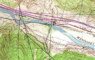 tural
and man made elements which made it a prime piece of farming property. Alongside
the southern banks of the Winooski River is a large tract of open meadows
(+/- 40 acres), rich in natural nutrients from river flooding, for the use
of pasture, hay fields and cropland for wheat, corn, oats, beans, peas,
and potatoes. Since the land was a prime farming location for Colonial settlers,
Native Americans and possibly pre-historic populations may have inhabited
the site. The open farm land meets the barns and the farmstead at the junction
of Duxbury Road and the Preston Brook where the land begins a rugged climb
up Camel's Hump Mountain to the south. Here the forests provided a bountiful
supply of wood for potash, building lumber, and fire wood, while the dramatic
pools and waterfalls became a prime location for the c. 1870 Preston saw
mill. Remains of the saw mill's foundation can be found along the western
edge of the Preston Brook. A 30' x 50' (approximate dimensions) U-shaped,
field stones and mortar foundation rises from the brook's edge, turns perpendicularly
along a deep gorge in a northerly direction, and is attached to a c. 1920
concrete wall as the foundation returns to the steep embankment. Looking
to the north from the farmstead, the Vermont Central Railroad meanders alongside
the Winooski River with Interstate 89 and the foothills of Mount Mansfield
located beyond.
tural
and man made elements which made it a prime piece of farming property. Alongside
the southern banks of the Winooski River is a large tract of open meadows
(+/- 40 acres), rich in natural nutrients from river flooding, for the use
of pasture, hay fields and cropland for wheat, corn, oats, beans, peas,
and potatoes. Since the land was a prime farming location for Colonial settlers,
Native Americans and possibly pre-historic populations may have inhabited
the site. The open farm land meets the barns and the farmstead at the junction
of Duxbury Road and the Preston Brook where the land begins a rugged climb
up Camel's Hump Mountain to the south. Here the forests provided a bountiful
supply of wood for potash, building lumber, and fire wood, while the dramatic
pools and waterfalls became a prime location for the c. 1870 Preston saw
mill. Remains of the saw mill's foundation can be found along the western
edge of the Preston Brook. A 30' x 50' (approximate dimensions) U-shaped,
field stones and mortar foundation rises from the brook's edge, turns perpendicularly
along a deep gorge in a northerly direction, and is attached to a c. 1920
concrete wall as the foundation returns to the steep embankment. Looking
to the north from the farmstead, the Vermont Central Railroad meanders alongside
the Winooski River with Interstate 89 and the foothills of Mount Mansfield
located beyond.
LINK TO BOUNDARY DESCRIPTION