Transitional Blocks: Maple Street to Main Street, east side
By Lynda Howell

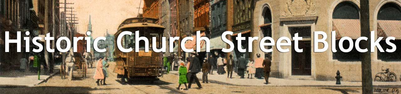
The character of Church Street changes when it crosses Main Street, particularly on the east side, and again at Maple Street. North of Main Street, the buildings are tightly packed and are primarily commercial in purpose. South of Maple Street, Church Street becomes primarily residential. Together, the two blocks in between form a transitional unit from public to residential.
Today, it is not immediately apparent why the character of the street should change so quickly. For much of Burlington's history, however, a deep ravine cut across the area, physically hindering development. King and Maple Streets ended at Church Street for their first hundred years. Development of the area depended on the shape, depth, and use of the ravine. Figure 1 shows the current layout of the streets and the surviving buildings.

The corner of the area least affected by the ravine was the first to be developed. Early in the nineteenth century, Seth Pomeroy built a house at the corner of Church and Main Streets. W.S. Rann's 1886 History of Chittenden County provides a description of the house at the time of the War of 1812: "The house was a small cottage building facing Main street, from which it was separated by a neat yard. Behind it was a large garden and an orchard." By the 1830s, when Burlington surveyor John Johnson surveyed it for its current owner, John Norton Pomeroy (Seth Pomeroy's brother), the house had been expanded and acquired several outbuildings (Figure 2). According to Johnson's notes, the house had a basement kitchen with fireplace, oven, and cooking stove. The main floor had another fireplace and two stoves. The main house as labelled on the image probably had a second floor with another fireplace. Overall, the house, outbuildings, and their contents were valued at $3,220.1
In the early 1850s, Pomeroy sold the house and lot to the United States Treasury for $7,750 to build a post office and custom house. One-time Burlington architect Ammi Young designed the new custom house: a two-story brick building with the post office on the ground floor and custom house above. Before this time, the post office had been housed wherever was convenient for the serving postmaster (usually somewhere on Courthouse Square). The main building of two stories was completed in 1857, with the third floor and mansard roof added in 1869-70 (see Figure 3). The photograph in Figure 4 is identified on the back as "Burlington P. O.". This was probably taken in the 1855 post office, but the number of windows does not quite correspond with those visible on the exterior in the previous view. This building served until the early 1900s, when it was replaced with the Beaux-Arts Classical Style building still standing on the corner of Church Street and Main (Figure 5).2


Maps from 1830 to 1869 showed a small L-shaped "brick dwelling" to the south of the Pomeroy-Custom House. In 1862, it was identified as the home of the "porter for Custom House," but the building was removed in conjunction with the building of the new Chittenden County Courthouse in 1872.3

Chittenden County had already had three courthouses by the 1870s. All had been located in the Courthouse Square, where City Hall Park is now. In 1872, the fourth courthouse (Figure 6) was built on the southern part of the Custom House lot, just fifty feet from the post office. The building was designed by Burlington architect E. C. Ryer in the Second Empire style, mostly two and a half stories with a three-story tower in one corner. It was built of the same local redstone quartzite that gives UVM's Redstone Campus its name, with contrasting limestone quoins, window arches, and cornices in blue-grey Isle La Motte stone. The 1869 act of Congress authorizing its construction on federal land allowed for a "court-house and jail," but the building does not appear to have been used as a jail.4
A hundred years later, the building was showing its age. One floor -- the one where sequestered jurors were housed -- had no heat or running water, the building needed $115,000 in "fire and wire" upgrades, and it was simply too small. In 1974, Chittenden County voters approved a bond issue to renovate the former post office and custom house next door -- at that point used as an army reserve center -- and work began. The courts had moved into the renovated building, but the old courthouse was still in use when it was severely damaged by fire in 1982. After as much as possible of the elaborately carved woodwork was salvaged, the building was demolished. At one time, some of the doors from the old courthouse were used at the Green Mountain Inn in Stowe, but their current whereabouts are unknown. The space is now a parking lot.5

By the early twentieth century, the 1855 Custom House was falling into disrepair and needed replacement. Before the existing building could be removed, a temporary post office had to be built. The current apartment building at 184 Church Street was that temporary post office (Fig. The land that building stands on hadn't even existed a few years before. An 1889 map shows the edge of the ravine just below the courthouse, with the label "foot of steep bank 25' high." That bank is clearly visible in the 1877 birds eye view of the custom house and new courthouse (Figure 7). Even today, there is a visible bank beside the parking lot where the courthouse used to be. The filling in of the ravine had created space for additional buildings: 184 Church Street is one of those. It served as post office from 1906 to 1908, and then as a laboratory for the Vermont Department of Health. Since 1919, when the laboratory moved to Colchester Avenue, it has been an apartment building.6
The last building on this block was also built on the filled-in ravine. 190 Church Street was built in the late 1890s as apartments, and has been so ever since. Originally, there was a third floor and the two turrets extended above the roof. In March 1961, a fire attributed to "children playing with matches" gutted the building. Two firemen were injured in the blaze (neither seriously), and more than thirty people living in the building were left homeless. It was rebuilt, and rentals resumed within a year, but the third floor and turret tops were not reconstructed.7
King Street was extended east across Church Street to what is now South Winooski Avenue in the 1880s, but nothing was built on the corner where the Burlington Telecom building at 200 Church Street now stands for many years after that. The building that now houses Burlington Telecom was built in 1951 as administrative offices for New England Telegraph & Telephone. After the telephone company moved out in the early 1970s, the University of Vermont (which had purchased the building in 1953) attempted without success to sell the building, and eventually converted it for storage of excess library materials. In 1980, the building finally sold and some of the proceeds were used to build the Library Research Annex on East Avenue. Since that time, and despite aborted efforts to convert it into a school or apartments, it has remained office space. Tenants have included Howard Mental Health, General Electric, and Long Distance North. Today, it houses the City of Burlington Human Resources department and Community Justice Center along with Burlington Telecom.8

The large parking lot next to this building sits at the deepest part of the ravine. The ravine -- being relatively level and unoccupied -- was a logical and cheap route to connect the railroad from Winooski to the lake through the village. Vermont Central Rail Road built tracks there in 1850, as shown in the 1853 map in Figure 8. The planned depot between Main and College Streets had not actually been built when this map was made. The ravine was, however, subject to flooding and landslides, so by the early 1860s, the railway line had been rerouted to is present course around the north side of downtown. The tracks in the ravine were mostly abandoned after the fall of 1862, and the tracks removed sometime after June 1863.9

No longer needed by the railway, the ravine became a sewer. Again, its lower elevation and general unsuitability for construction made the ravine a logical choice. Some of the sewer lines remain in parts of the former ravine today. Flooding remained a problem, however, even after much the the ravine was filled in. Figure 9 shows repairs being made to the sewer following a 1929 "exceptional rain storm".10

The steep bank still visible along Church Street shows how much the road was built up in the 1880s (see Figure 10). "The immense hollow which formerly existed on Church street where it crosses the ravine," reported the Burlington Weekly Free Press in December of 1885, "has been raised to the dignity of a gradual slope between Main and Maple streets." The stone retaining wall along the side of the parking lot keeps the higher roadway in place. The storage sheds visible in the background of Figure 9 line the retaining wall with the road surface just above them.11
In 1878, Horatio N. Coon made a proposal to the City that he should be allowed to "dam the open sewer which runs through [the ravine at Church Street] until sufficient water is obtained to furnish ice, and then to cream the whole over with hydrant water to the depth of an inch or so, to form a clean and even surface" for ice skating. The committee on sewers wasn't even willing to consider the idea, apparently finding it distasteful, and convinced the Board of Aldermen to "kill" the proposal without further ado. Nevertheless, Coon advertised that a "skating rink is to be opened in the swamp back of the post office, (when it freezes,)" but the experiment does not appear to have been so successful as to be repeated in later years.12

In 1894, John R. McLaren opened a longer-lived (and apparently sewage-free) skating rink in the same place. The Green Mountain Skating Rink was designed to be "a desirable resort for ladies and children, and where costume and masquerade parties can be given under proper auspices." It was a large building, with about 20,000 square feet of rink space, electric lights, and heated waiting and refreshment rooms. A season ticket (lasting from New Years Day to the thaw) cost $5 for men, $2.50 for women, and $2 for children. Military bands, barrel races, and "half mile backward" races provided extra entertainment (Figure 11). In the summers, a hardwood floor allowed roller skating, while the enormous space could house an entire regiment of visiting Canadian artillery or host a dog show.13

When the Green Mountain Skating Rink closed in 1902, the enormous space was turned into Salls' Exchange (Figure 12). "The largest store in the State of Vermont," Salls' "contain[ed] 35,000 feet of floor space" and bought and sold "everything from a coffin to a carpet [tack]" in an early predecessor of today's big-box stores. Even the University of Vermont shopped at Salls, as the 1909 Ariel yearbook reported disapprovingly: "[Old Mill] was originally built in three parts but, during the night of the big wind, the two ends were blown against the chapel and, in order to save trouble, the Trustees stuck it together with Le Page's glue, bought a second-hand furnace from Sall's Exchange and called it a college building."14
In 1911, most of the building was converted to light industry. A "wooden toy and novelty" factory took over the front part of the building, some was used as storage for builder's supplies, and a part was moved a little way apart and became the National Paper Tube and Box Company. This company specialized in producing a "patented mailing tube which is a device contrived to pull paper, etc., from the tube with no difficulty" and also made specialized boxes for a range of local and out-of-town businesses. Barely a year old, they had already outgrown their original space on Mechanics Lane. They continued to grow and to flourish in the former skating rink for the next five years. In September 1917, they announced plans for an addition to the building, increasing capacity from four thousand boxes a day to twenty. Barely a month later, however, a "spectacular" fire did $50,000 in damage to the old skating rink complex. The National Paper Tube and Box Company moved from Church Street to the Arbuckle Building where they were back in production within weeks, and by March of 1918 were producing thirty to forty thousand boxes a day. The toy factory was less fortunate -- or less well managed -- and did not recover. Several small sheds that were salvaged from the building or built after the fire remained in use as storage until the 1960s.15

As Maple Street grew beyond Church Street while the ravine still gave it a certain isolation, it became a residential street lined on both sides with single-family houses and small tenements. The duplex on the corner with Church Street is one of these. Currently known as 174-176 Maple Street, but previously numbered as 222-228 Church Street, this building was probably built around 1890 "as an income producing tenement for an absentee builder-landlord." It is a two-and-a-half-story stuccoed duplex combining Queen Anne and Colonial Revival elements typical of buildings of its kind throughout Burlington. The original six large apartments were divided in the 1940s to make sixteen units, some of which consisted of single rooms and shared bathrooms. In 1979, a fire damaged the second floor beyond what the landlord could afford to repair, and the building became a focal point of rent activists critical of the city's failure to seek out and help residents of substandard housing. The King Street Revitalization Corporation purchased the building with the assistance of a federal grant in 1980 and converted it to subsidized housing.16
Within the two short blocks from Main Street to Maple Street, the character of Church Street changes from the bustle of primarily commercial and public buildings to primarily residential. The residential character increases even more below Maple Street, but that is beyond the scope of this project. Without the presence of the ravine in Burlington's early years, the east side of Church Street below Main Street would probably resemble the west side and northern blocks more closely. Without the filling of the ravine, it might well have remained as remote and inaccessible as when Seth Pomeroy built his house on the only usable land at the corner of Church and Main.
NOTES
1. William S. Rann, ed., History of Chittenden County, Vermont (Syracuse: Mason, 1886), 408, accessed at books.google.com; John Johnson, "Property of John Norton Pomeroy, Main and Church Streets," John Johnson Papers, UVM Special Collections.
2. "Our Custom House," Burlington Free Press, December 8, 1854, 2, accessed at chroniclingamerica.loc.gov; Burlington, Chittenden County, Vermont (New York: Sanborn-Perris Map Co, Nov. 1894), Sheet 17, accessed at www.loc.gov; William S. Rann, ed., History of Chittenden County, Vermont (Syracuse: Mason, 1886), 492-493, accessed at books.google.com; A history of public buildings under the control of the Treasury Department (Washington: GPO, 1901), 585, accessed at archive.org.
3. Fire Insurance Maps of Burlington, Vermont (New York: Sanborn Map Company, 1869), Sheet 3, accessed at cdi.uvm.edu; Map of Burlington, Vermont (New York: Presdee & Edwards, 1853), accessed at cdi.uvm.edu; The Village of Burlington, Vt. (Burlington: Burlington Free Press Office, 1862), accessed at cdi.uvm.edu.
4. Nomination Form: Chittenden County Courthouse (Washington: National Park Service, 1972), 2, accessed at orc.vermont.gov; A history of public buildings under the control of the Treasury Department (Washington: GPO, 1901), 585, accessed at archive.org.
5. Connie Cain Ramsey, "History of the Chittenden County Courthouse," The Burlington Free Press, September 22, 2017, accessed at www.burlingtonfreepress.com; Devin A. Colman to J. Paul Loether, January 28, 2016, National Park Service, accessed at www.nps.gov; Ken Biedermann, personal communication with author, October, 2018.
6. "Burlington, Vermont." (New York: Sanborn Map & Publishing Co., June 1889), Sheet 4, accessed at www.loc.gov; "New Home for State Board of Health," The Burlington Free Press and Times (Burlington, VT), March 6, 1919, 12, accessed at vsara.newspapers.com.
7. "Fires," The Burlington Free Press (Burlington, VT), October 13, 1961, 10, accessed at www.newspapers.com; "Families Escape Apartment Fire," The Burlington Free Press (Burlington, VT), March 13, 1961, 11, accessed at www.newspapers.com; "Three Rooms -- Spacious new and beautiful," The Burlington Free Press (Burlington, VT), February 17, 1962, 17, accessed at www.newspapers.com.
8. Whittier & Goodrich Architects, "Accounting Headquarters for the New England Tel. & Tel. Co.," November 1951, Land Records Office, UVM Archives, UVM Silver Special Collections; "Church 200 SE Cor King St," Burlington City Real Estate Assessments Collection, UVM Silver Special Collections; "UVM Trustees Accept Millions in Gifts, Grants," The Burlington Free Press (Burlington, VT), August 21, 1972, 9, accessed at www.newspapers.com; "Board Favors Memorial Auditorium for Library," The Burlington Free Press (Burlington, VT), May 14, 1974, 17, accessed at www.newspapers.com; "UVM Trustees to Consider $83 Million Budget," The Burlington Free Press (Burlington, VT), June 15, 1979, 5B, accessed at www.newspapers.com; "Burlington Aldermen," The Burlington Free Press (Burlington, VT), May 6, 1974, 17, accessed at www.newspapers.com; "Public Hearing," The Burlington Free Press (Burlington, VT), April 13, 1986, 7B, accessed at www.newspapers.com; "Business Notes.," The Burlington Free Press (Burlington, VT), February 27, 1981, 5B, accessed at www.newspapers.com; "Long-distance firm bought by N.Y. company," The Burlington Free Press (Burlington, VT), November 20, 1990, 6A, accessed at www.newspapers.com.
9. "Central Route," The Burlington Courier (Burlington, VT), February 7, 1850, 2, accessed at vsara.newspapers.com; "Improvements at the Lake Shore," Burlington Weekly Sentinel (Burlington, VT), May 29, 1863, 3, accessed at vsara.newspapers.com.
10. Louis L. McAllister, "Break in ravine sewer by pressure from exceptional rain storm, June 1929," Louis L. McAllister Photographs, UVM Silver Special Collections.
11. "Burlington's Streets," The Burlington Weekly Free Press (Burlington, VT), December 18, 1885, 6, accessed at vsara.newspapers.com.
12. Hiram S. Hart, Burlington City Directory and Business Advertiser (Burlington, VT: Free Press, 1865), 30; "The Central," The Burlington Weekly Sentinel (Burlington, VT), January 4, 1850, 2-3 accessed at vsara.newspapers.com; "G. W. Benedict v. B. J. Heineberg," Reports of Cases Argued and Determined in the Supreme Court of the State of Vermont (Montpelier: Poland, 1871), Vol. 43, 232, accessed at books.google.com; "What the City Fathers Did," The Sunday Review (Burlington, VT), December 14, 1878, 4, accessed at vsara.newspapers.com; "Burlington Notes," Democrat and Sentinel (Burlington, VT), December 14, 1878, 2, accessed at vsara.newspapers.com.
13. "Covered Skating Rink," The Burlington Free Press and Times (Burlington, VT), November 13, 1894, 5, accessed at www.newspapers.com; "Amusements," The Burlington Free Press and Times (Burlington, VT), December 21, 1894, 5, accessed at www.newspapers.com; "Sport at the Rink," The Burlington Free Press and Times" (Burlington, VT), March 16, 1897, 5, accessed at www.newspapers.com; "Queen City News," The Burlington Clipper (Burlington, VT), April 16, 1896, 4, accessed at vsara.newspapers.com; "Canadian Gunners," The Burlington Clipper (Burlington, VT), July 8, 1899, 1, accessed at vsara.newspapers.com; "Burlington," The Burlington Clipper (Burlington, VT), August 3, 1901, 1, accessed at vsara.newspapers.com.
14. "Our First Bow to the Public," The Burlington Clipper (Burlington, VT), June 28, 1902, 8; "Sall's Exchange," The Burlington Clipper (Burlington, VT), July 26, 1902, 4; "Uncle Joe Says," The Burlington Clipper (Burlington, VT), September 6, 1902, 8, accessed at vsara.newspapers.com; "Seeing the University," Ariel (Burlington, VT: UVM, 1909), 268, accessed at cdi.uvm.edu.
15. "Insurance Maps of Burlington, Chittenden County, Vermont." (New York: Sanborn Map Company, October 1912), Sheet 20, accessed at www.loc.gov; "Vermont News," Montpelier Evening Argus (Montpelier, VT), June 17, 1907, 7, accessed at vsara.newspapers.com; "In New Quarters," Burlington Daily News (Burlington, VT), June 26, 1908, 2, accessed at vsara.newspapers.com; "Spectacular Blaze on Lower Church St. Does $50,000 Damage," Burlington Weekly Free Press (Burlington, VT), October 11, 1917, 1, accessed at vsara.newspapers.com; "Local Concern Increases Capital from 20 to $50,000," Burlington Daily News (Burlington, VT), March 7, 1918, 8, accessed at vsara.newspapers.com; Burlington, Vt, Including Winooski and Parts of the Towns of South Burlington, Colchester, and Shelburne (New York: Sanborn Map Company, 1960), Sheet 4, UVM Special Collections.
16. Nomination Form: Amendment to the Battery Street Historic District (Washington: National Park Service, 1984), 25, accessed at npgallery.nps.gov; "No Lights, Telephone Nor Heat, Building Still Has Four Tenants," The Burlington Free Press (Burlington, VT), October 12, 1979, 1B, accessed at www.newspapers.com; "Rent Activists Hurl Criticism at Mayor on City Hall Steps," The Burlington Free Press (Burlington, VT), October 20, 1979, 1B, accessed at www.newspapers.com; "King Street Project Given Nod for Grant," The Burlington Free Press (Burlington, VT), December 5, 1979, 3B, accessed at www.newspapers.com; Chester Liebs, ed., The Burlington Book: Architecture, History, Future (Burlington, VT: UVM, 1980), 88.