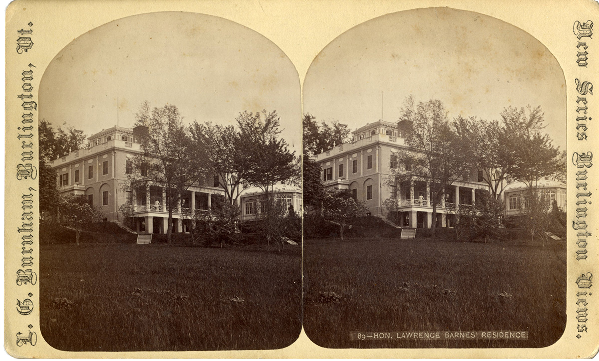
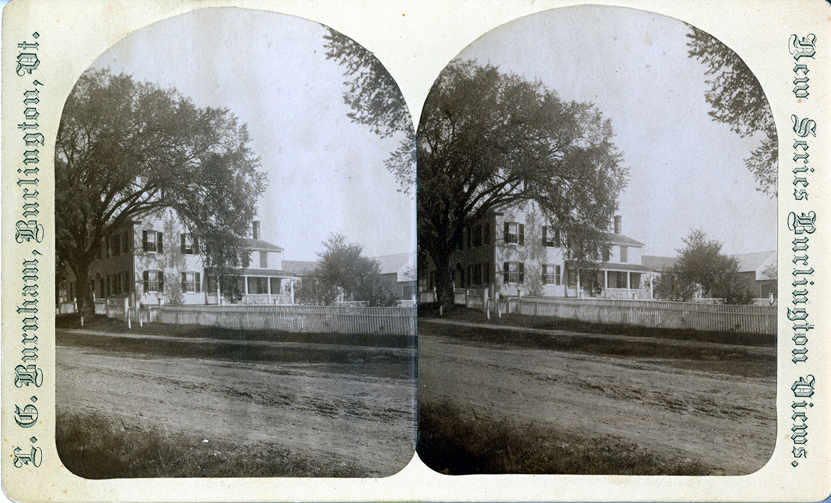
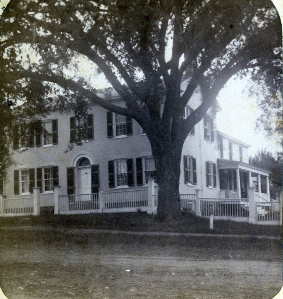
The subject of this stereograph is a beautiful Federal style neo-classical structure. On the front of the stereograph is printed “89-Hon. Lawrence Barnes’ Residence.” A woman appears on the porch in a white dress that might reflect the 19th or early 20th century. Nothing is written on the back of the stereograph, and no additional information is given on the card.
Fig. 1. Stereograph Image 1. Courtesy of University of Vermont Special Collections.
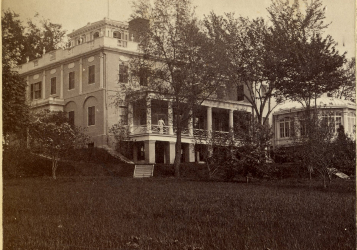
Fig. 2. Cropped Image 1.
Today
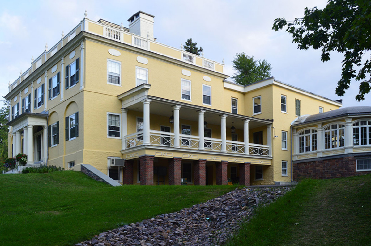
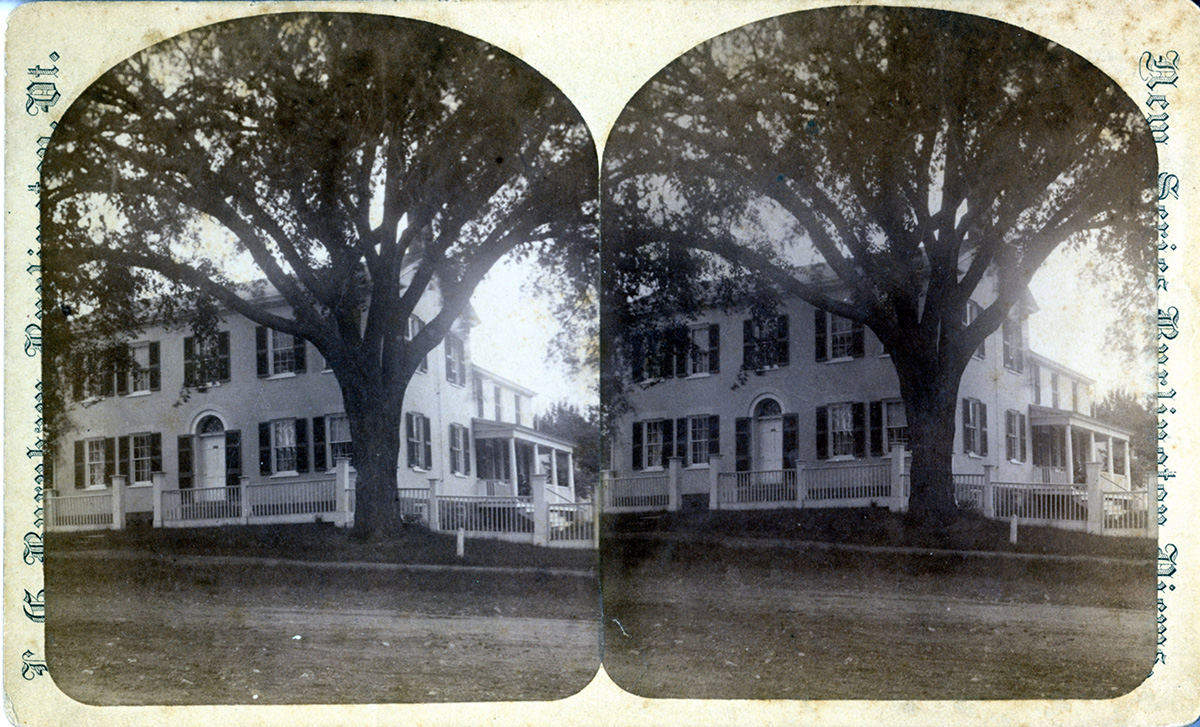
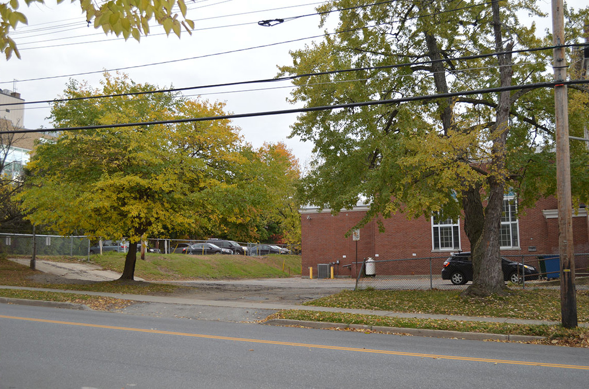
This structure is what became known as Grasse Mount, which still stands at 411 Main Street, Burlington, Vermont. It is a prominent building on Main Street. It is also a University of Vermont building, currently the home of the Office of Development and Alumni Relations.
Fig. 3. Grasse Mount: Office of Development and Alumni Relations, University of Vermont (view looking east-southeast from Main Street). Photo by author, October 2014.
Today’s color image from the same vantage point brings the structure to life. The old home is impressive. It appears to be in as good a condition as it was in the old stereograph. Small changes are apparent, such as a stone drainage basin that now runs down a slope toward Main Street. It also appears that side of the property has been landscaped lower than the vantage point of the stereograph photo. A few trees and shrubs that were apparent in the stereograph are gone. Overall the old and new images look very similar, and the structure itself shows very little change.
History
Grasse Mount was built in 1804 as a private residence by a leading merchant in Burlington named Captain Thaddeus Tuttle.1 It was sold to Vermont’s Governor Van Ness in 1824 and was the site of a “brilliant reception” in 1825 by the Governor for the famous French General LaFayette.2 The home was “at that time considered the most elegant private residence in Burlington.”3 In 1866 the house became the home of Lawrence H. Barnes4, a prominent Burlington businessman who co-owned a lumber company called “Skillings, Whitneys, and Barnes Lumber Co.”5 and was later the President of “Howard National Bank.”6
To find the date the stereograph image was taken, a general time period can be established simply by a general history of photography and stereographs. Stereographs were an early form of three-dimensional photography, professionally produced, that first appeared in 1859 and were most popular during the 1870s and 1880s, continuing until approximately 1910. More specifically the image was taken while L. Barnes was residing there as indicated by the original text printed on the front of the stereograph.
Mr. Barnes was living at the home starting in 1866 according to the Burlington City Directory of that year: “Barnes, Lawrence, firm L. Barnes & Co, h corner Main and Summit streets.”7 The structure is also shown as belonging to L. Barnes on an 1869 Burlington map.8 It is not until the 1881-1883 Burlington City directory that the address of 411 Main Street is given, which is the same address for Grasse Mount today. Mr. Barnes lived at this address until his death in June of 1886: “The death of Mr. Barnes…removes from our community one of its most conspicuous and most esteemed citizens.”9 Mrs. Barnes continued to live at Grasse Mount until her death on November 4th, 1892.10
The date range of the stereograph is therefore between 1866 and 1886. It is possible that the date range can be further narrowed based on research of other stereographs taken from the belvedere at the top of Grasse Mount (see images 8 and 9). It is likely those stereographs were taken at the same time as this one, which would indicate 1877 as the latest possible date, discerned by structures either drawn or not drawn on two different maps of Burlington from 186911 and 1877.12 However, since Image 1 was not confirmed to have been taken at the same time as Image 8 or 9, the date range of this stereograph is best verified as between 1866 and 1886.
Image 2
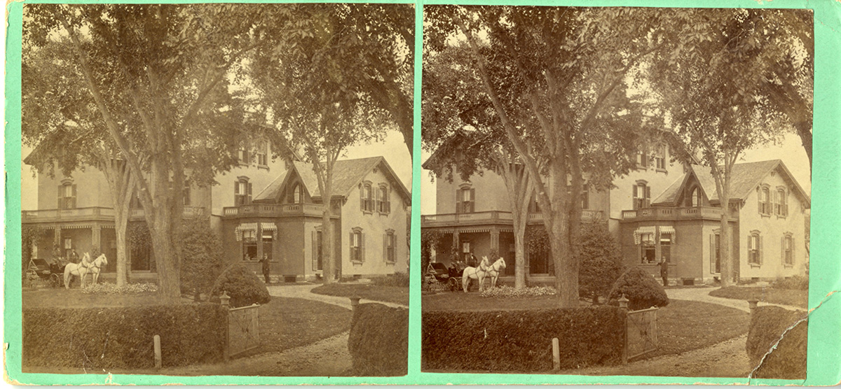
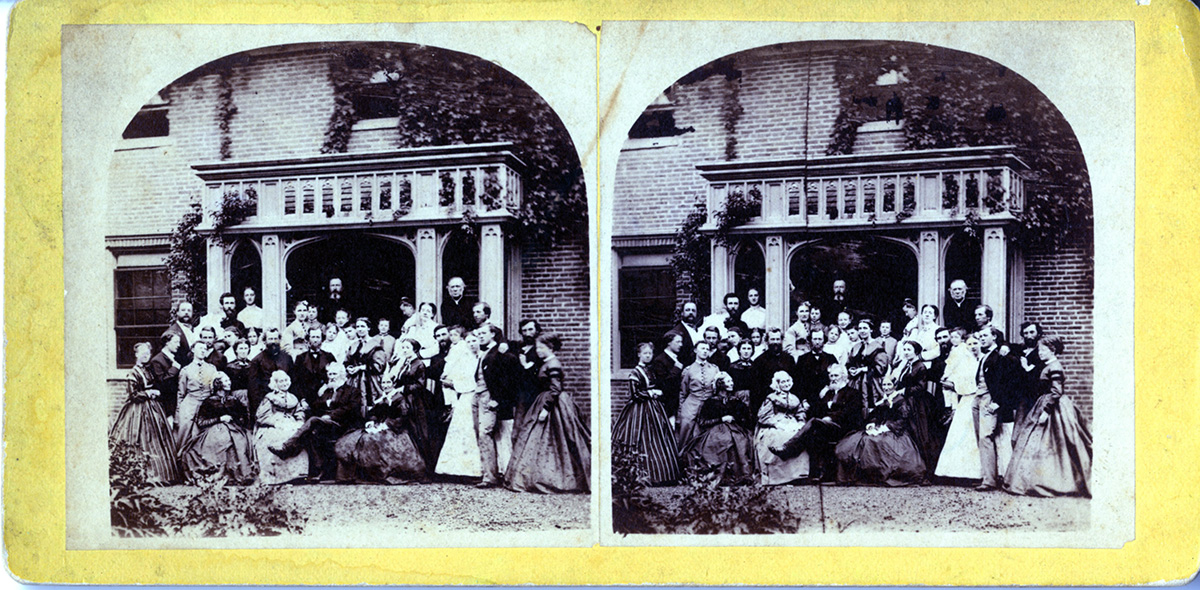
The subject of this stereograph is a large elegant home with a circular drive. Hints of Romantic era styling exist in the ornate woodwork on the flat-roofed veranda, decorative brackets under the roof soffits, and arched window lintels. A single pointed arched window appears in a front gable which gives it a Gothic look. The home appears to be made of smooth masonry or brick.
At the top of the drive is a horse and carriage with its driver and another fellow. Both of the men are well dressed and wearing black top hats. They appear to be waiting for something to happen. Perhaps the owner or someone of note is preparing to depart. Another well-dressed gentleman and a second person in the window at the right look on. The dress suggests the Civil War era into the late 1800s. A well-manicured lawn and hedges indicate a wealthy homeowner. The front of the stereograph has no text. In pencil on the back of the stereograph is handwritten “DC Linsley house…also known as Richardson House.”
Fig. 4. Stereograph Image 2. Courtesy of University of Vermont Special Collections.
Fig. 5. Cropped Image 2.
Today
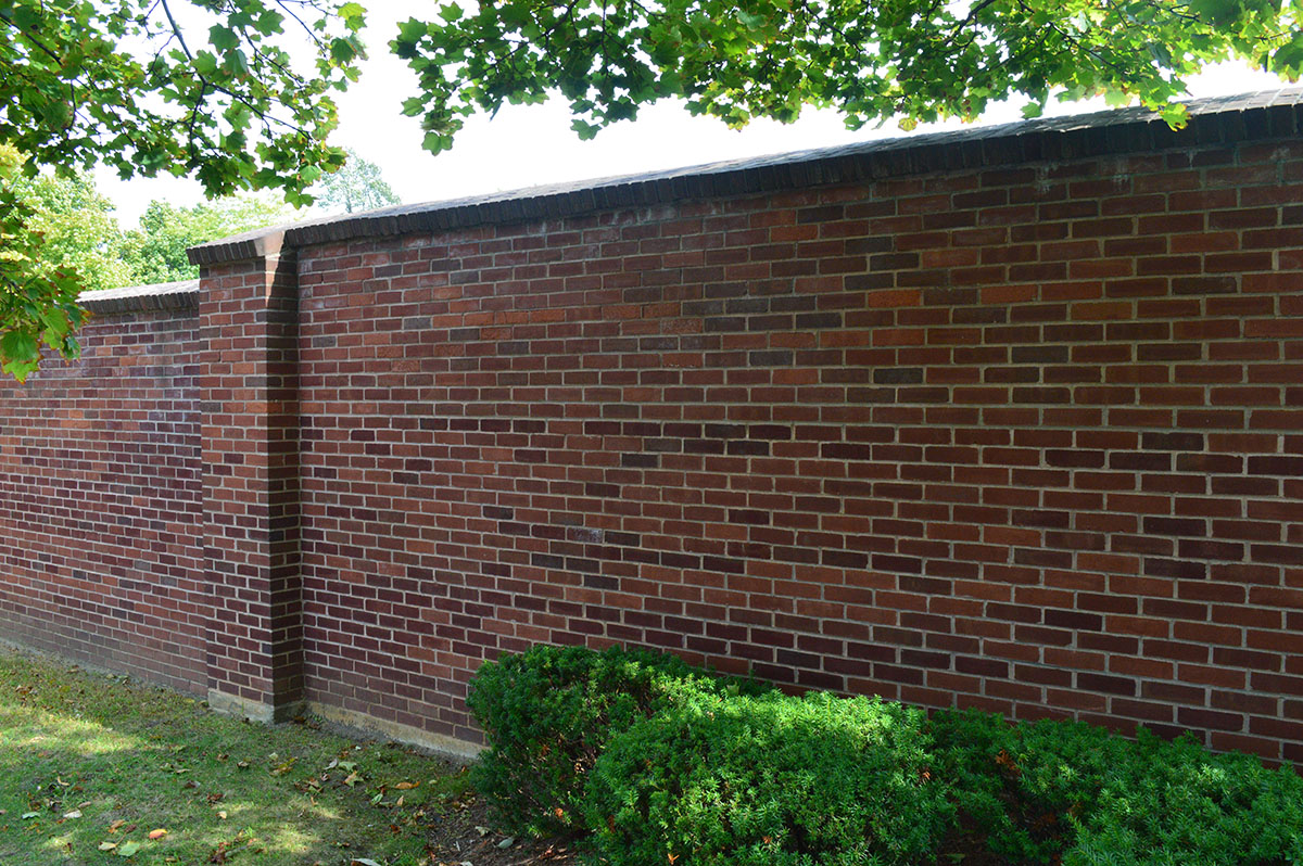
The home formerly stood at what is now 52 Williams Street. A large brick wall extends along the edge of the property and blocks the view of the former location that is now a parking lot for the University Health Care Campus.
Fig. 6. Formerly 52 Williams Street (view looking east-northeast from the eastern boulevard of Williams). Photo by author, October 2014.
History
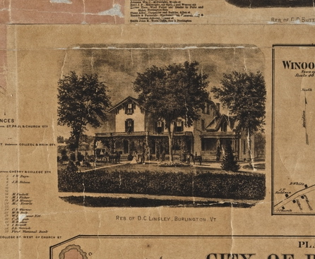
An artist’s rendition of this home perfectly matches the image on an 1869 map, labeled “RES. OF D.C. LINSLEY, BURLINGTON, VT” (see below).13 On the same map is a lot and drawing marked “D.C. Linsley”14 with an exact footprint of the home pictured, including the circular driveway, on the east side of Williams Street. The lot extended all the way from Williams Street east to Green Street, now South Prospect Street. The 1865 Burlington City Directory lists D.C. Linsley as residing at “Williams between College and Pearl Sts”15 which lines up with the location on the map. This was indeed the D.C. Linsley home.
Fig. 7. Image of the home on the 1869 Worley and Bracher Plan of the City of Burlington. (Courtesy of University of Vermont Special Collections.)
D.C. Linsley was a civil engineer and the president of a company called B&LRR located at 33 Maple Street.16 He lived with Fannie Linsley at the home, presumed to be his wife.17 The last years the Linsley’s are listed at this address were 1884-1885. The 1886-1887 directory does not list them at all. If the stereograph was taken while the Linsley’s occupied the home then it was taken prior to 1887. The Linsleys lived there in 1865, but the exact date they moved into the home was not found. The home was not drawn at that location on an 1862 Burlington map and the name listed on the map at that location was “J.S. Adams.”18 Therefore the date range for the stereograph can be verified as after 1862 to as late as 1885.
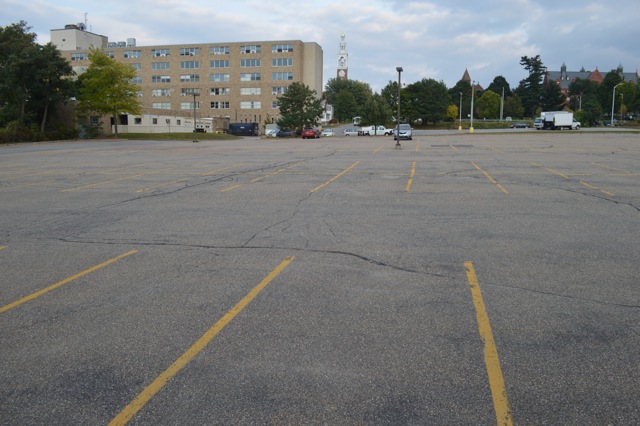
The history of the demise of this structure may be found through a 1978 Vermont State Supreme Court case: Committee to Save the Bishop’s House et al vs. Medical Center Hospital of Vermont, Inc.19 The case describes a struggle to save the home after it was sold to the Medical Center of Vermont by the Catholic diocese of Vermont. It had been most recently the home of the acting Catholic Bishop. Ultimately the court did not rule for the Plaintiffs who sought to protect the structure under a Vermont environmental law known as Act 250. The result was the home’s demolition for a parking lot.
Fig. 8. Parking lot beyond the wall, former site of D.C. Linsley home (view looking east). Photo by author, October 2014.
Image 3
A large group of people is posed in front of a brick structure with a classical portico with romantic stylings that might be a home or business. They appear to be celebrating a special occasion or family gathering. On the back of the stereograph is handwritten “Bishop Hopkins’ Golden Wedding.” The front has no text and no other information is given.
Fig. 9. Stereograph Image 3. Courtesy of University of Vermont Special Collections.
Fig. 10. Cropped Image 3.
Today
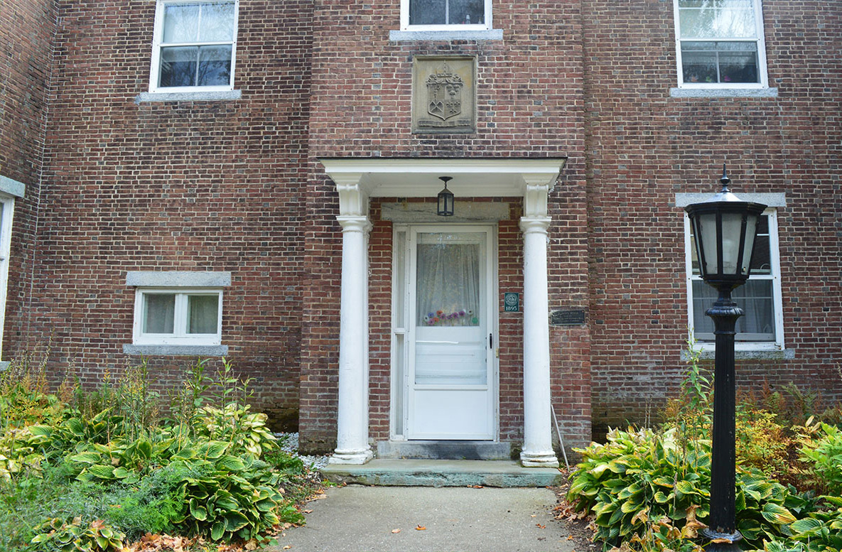
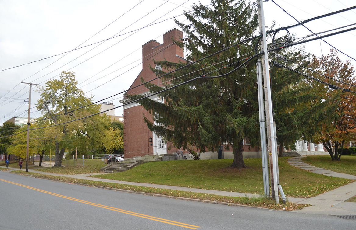
The location was found to be outside the Hill Section. It is north of downtown past the current Burlington High School on Institute Road near what is known as Rock Point. This is the site of the former home of John Henry Hopkins, Bishop of the Vermont Episcopal Church. The home pictured was built in 1894 as a replacement for the older home.
Fig. 11. Bishop's Home, Rock Point School, Institute Road (view looking south-southeast). Photo by author, October 2014.
History
The stereograph is the family of Bishop John. H. Hopkins in front of his home on their 50th wedding anniversary. Bishop Hopkins is pictured front and center with his wife Melusina,20 their nine living children,21 grandchildren, and other relations in surround. It took place in June of 1866, as reported in the Burlington Weekly Free Press: “The golden wedding of the venerable Presiding Bishop of the United States, Bishop Hopkins of Vermont, and his estimable lady, took place at the episcopal and family homestead, at Rock Point, Vermont, on the borders of Lake Champlain, last week, and continued from Wednesday evening to Friday morning.”22 “The Bishop is now in his 76th year, having been married in 1816 and both he and Mrs. Hopkins are in the most robust and excellent health. The exercises consisted of social enjoyment, the relation of family reminiscences, music, etc., and finished by a bounteous old-fashioned standing supper.”23 Among the gifts presented was “a chain made from the Bishop’s hair, given to Mrs. Hopkins – white as silver.”24 “Before separating, the members of the family sang the…Golden Wedding Song, at the conclusion of which there was scarcely a dry eye in the room.”25
Bishop John H, Hopkins founded the Vermont Episcopal Institute in 1832, also known as the Bishop Hopkins School for Boys.26 The location of the first school was his residence at 272 Church Street27 that he had “enlarged…by adding wings with Federal style parapet gables.”28 That home was apparently listed in a later-year historic sites survey as “one of the most historic structures in Burlington.”29 Though it is not the location of the stereograph, the structure remains today as a part of a larger nursing home facility for the elderly.
A new building was eventually built for the institute at Rock Point, a scenic location near Lake Champlain on the north side of Burlington near today’s Burlington High School.30 The institute was also called Bishop Hopkins Hall, which opened in 1860 with the Bishop’s son Rev. Theodore A. Hopkins at the helm. Bishop John H. Hopkins was referred to as “a saintly man” and his Institute “the realization of (his) dreams.”31 It was considered an English, classical studies, and math preparation school. “Daily military drill under a special instructor was required of all pupils. Instruction in military tactics was also given. It was really a very high grade boys’ school.”32 The building stands today on Institute Road, owned by the Rock Point School in current operation.
The Burlington City Directory for 1867-1868 lists Rev J.H. Bishop as residing at “Rock Point, near Episcopal Institute.”33 Today, farther up Institute Road from the former institute is a sign pointing to “Bishop’s House.” After winding through a scenic wooded area one arrives at a late 19th century brick home. “On the rise known as Hemlock Hill, Hopkins built a house where until his death in 1868 he raised his large family, administered the small Episcopal diocese and oversaw the school he founded.”34 The newer home that still stands was built in 1894, “a typical Edwardian brick country house.”35 The home appears to be an administrative building for Rock Point School. It is a large rectangular two-story building with classical features and a brick facade similar to the old home, built at the same location.
Despite reportedly good health during the anniversary in 1866, Bishop Hopkins died in January of 1868: “In the death of Right Reverend John Henry Hopkins…most eminent in his church, and most widely known on both sides of the Atlantic, has suddenly passed away.”36
Images 4 and 5
Pictured in these two stereographs is a dirt road and a two-story home in what could be the Federal style with delicately stated classical features such as the decorative fanlight over the front entrance. Looking closely it appears to be of masonry construction. A well-dressed man sits on the covered porch attached to a large addition at the back. Image 4 shows an entire lot open in the foreground. A large tree stands out front and a straight white picket fence runs the length of a dirt road with a sidewalk next to it. On the back of the stereograph is handwritten “Mr. Stearns’ House.”
Fig. 12. Stereograph Image 4. Courtesy of University of Vermont Special Collections.
Fig. 13. Cropped Image 4.
Today
The location is the corner of Pearl and Williams Streets where the E.B. Taft School now stands.
Fig. 14. Corner of Pearl Street and Williams, side of E.B. Taft School, 14 Williams Street (view looking southeast from Pearl Street). Photo by author, October 2014.
Fig. 15. Stereograph Image 5. Courtesy of University of Vermont Special Collections.
Fig. 16. Cropped Image 5.
Today
The home faced Pearl Street at the back of the current E.B. Taft School.
Fig. 17. Formerly 397 Pearl Street, behind E.B. Taft School (view looking south-southeast). Photo by author, October 2014.
History
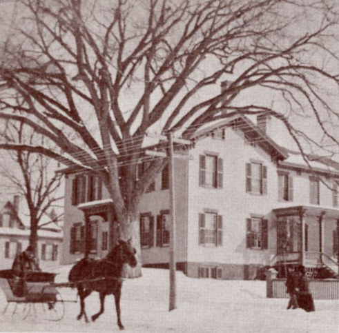
The 1865 Burlington City Directory lists a Nathan Stearns as living on “Pearl Street near William.”37 “N. Stearns” is also shown at that location on an 1862 map of Burlington.38 On the 1869 Beers map of Burlington an N. Stearns is shown at the same location with a structure drawing that matches the footprint of this home. A similar photograph is shown in a secondary source called Bygone Burlington. That book shows a one-horse sleigh coming up along the road with the caption “sleighing past E.B. Taft’s home on the southeast corner of Williams and Main” (see below).39
Fig. 18. Home of E.B. Taft circa 1900.
Williams and Main Street, however, is not the same area as the Nathan Stearns location. Williams meets Main Street head on, and if there were a southeast corner of Williams and Main it would be across Summit Street from Grasse Mount where another 1800’s era home currently stands. Based on the way that home stands on that corner lot and the general lay of the land it simply could not be the correct location of the photograph. The authors must have meant the southeast corner of Williams and Pearl, and indeed that is where one finds the former location of E.B. Taft’s home. The photo in David Blow's book also shows a few added features on the home, such as a front portico, decorative brackets, and other Romantic style details. The tree in front of the house, however, looks exactly the same.
In the 1877-1878 directory is found Elihu B. Taft listed as “bds with Mrs. E Stearns”40 and the 1881-1883 directory lists Mrs. Emily Stearns at 397 Pearl Street, which again coincides with the 1869 map drawing and N. Stearns location. It is not apparent what happened to N. Stearns but a connection between Taft and Mrs. Stearns is evident, as previously E.B. Taft had been living at a different address. It is not until 1892 that we find E.B. Taft listed at number 397 on Pearl Street, although it is the same location since 1877 and he is continually listed at that address until his death in 1929.41
The stereograph is the former home of Nathan Stearns and later, Elihu B. Taft. It was located at 397 Pearl Street that is now the site of the Elihu B. Taft School at 14 South Williams Street. The school faces Williams at the southeast corner of Pearl Street, whereas the house in the stereograph faced Pearl Street. When E.B. Taft died in 1929 he left $125,000 to erect a school on his former property.42
The modern photographs are taken looking east-south east up Pearl Street along the side of the present-day school building. The estimated date of the stereographs are when “Mr. Stearns” (Nathan Stearns) was living at the home, circa 1862 to 1877.
Image 6
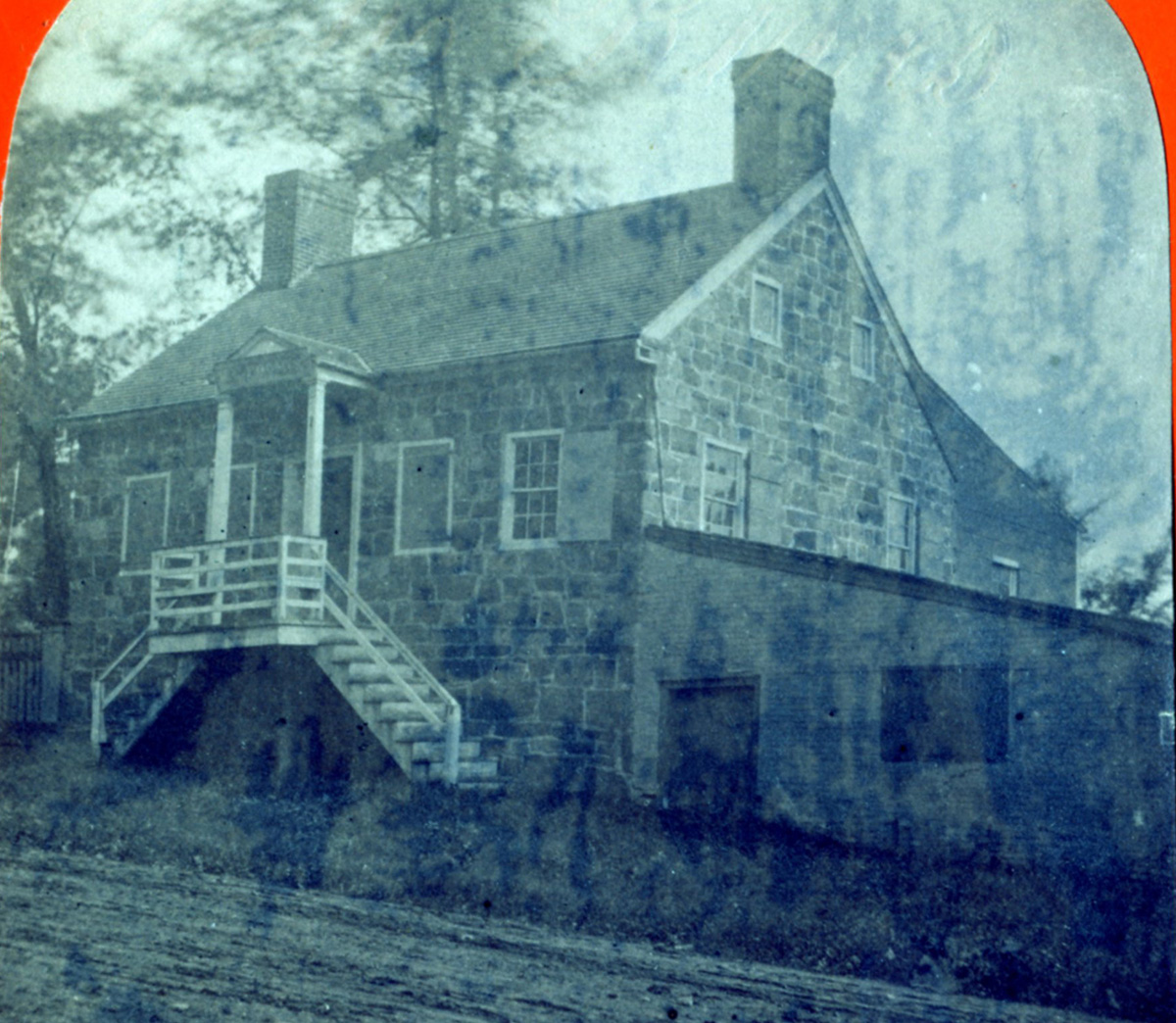
This stereograph is of a stone structure located along a dirt road that heads up a hill to the left side. According to handwriting on the back of the stereograph, this was “The Old Stone Shop, built in 1807 by Horace Loomis. Torn down October 1881, opposite the Klifa Club on Pearl St.” It is an interesting building with irregular cut stone and a simple front portico. At first glance it looks to be a home, but the right side of the building has an addition that looks more business-oriented. With the old stone shop indication the impression is given that this was a business.
Fig. 19. Stereograph Image 6. Courtesy of University of Vermont Special Collections.
Fig. 20. Cropped Image 6.
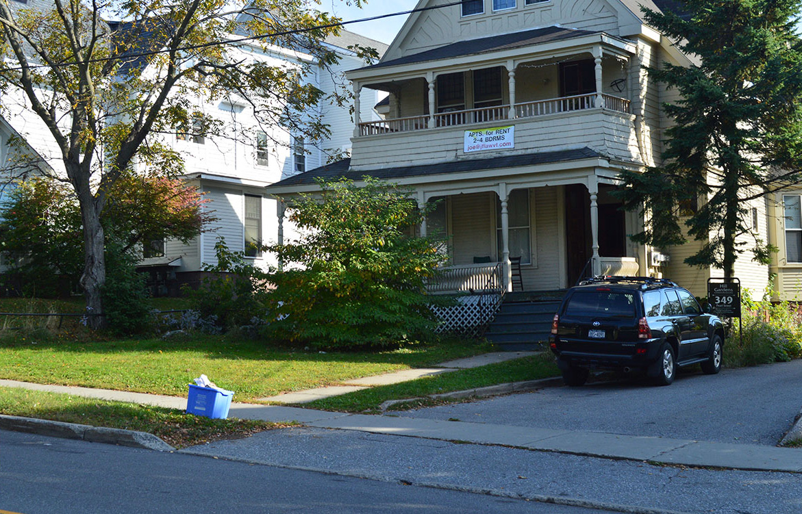
Today
The stone buildling was reportedly torn down in 1881. The location was 349 Pearl Street.
Fig. 21. 349 Pearl Street (view looking south-southeast). Photo by author, October 2014.
History
The Klifa Club was a 20th century women’s organization that no longer exists.43 It was founded in 1900 to “promote social intercourse and an interest in literature, science, art, and the leading questions of the day.”44 Its location was 342 Pearl Street and the building that housed the club still stands. It is a Federal period home owned at one time by an H. (Horace) Loomis as indicated on the 1869 Beers map. That map also shows a structure drawing on the opposite side of Pearl Street, marked as “Office” and indicates yet another building behind it on the same lot as “Tannery.”45
This structure was the office for the tannery that made leather for goods sold by an E.C. Loomis and partners. The firm was listed in the Burlington Weekly Free Press in 1866 as a participant in the county fair: “E.C. Loomis & Co., Burlington, very fine exhibition of the various grades of leather, mostly of their own production.”46 In 1868 a newspaper article confirms his shop was on Pearl Street: “Mr. E.C. Loomis has kept his leather store on Pearl Street since 1832.”47 In 1869 the company is listed as E.C. Loomis & Son, “steam tannery and currying shop, Pearl st.”48
If one looks closely the word "Loomis" can be seen above the doorway. The Beers 1869 map as well as the Burlington City Directory of 1866-1867 indicate E.C. Loomis as residing on Pearl Street right next door east of the structure: “firm Loomis & Co., h corner Pearl and William sts.”49 Also, one of Loomis’ partners, A.W. Allen, is listed as living next door to the structure on the west side, “firm Loomis & Co., h Pearl Street, between Willard and William.”50
By the 1875 Burlington City Directory E.C. Loomis is no longer listed as “firm Loomis & Co.” as it had in previous directories. In 1881 his partner A.W. Allen is listed with another firm, “Allen and Green.” 51 These factors coincide with the “Old Stone Shop” having been torn down in 1881 per the handwritten note on the back of the stereograph. An 1890 Burlington map verifies the shop was not there in that year as different structures are drawn in that location.52 Since Mr. Loomis was doing business at the shop since 1832 the date range of the stereograph can only be narrowed to between the advent of stereographs and when the building was torn down, circa 1859 to 1881.
The vantage point of the image is the front boulevard of 342 Pearl Street (the former Klifa Club) facing south and slightly eastward. The modern photo shows a similar rise of the street as well as current homes in view that match structures and lot lines shown on the 1890 map of Burlington.53
Image 7
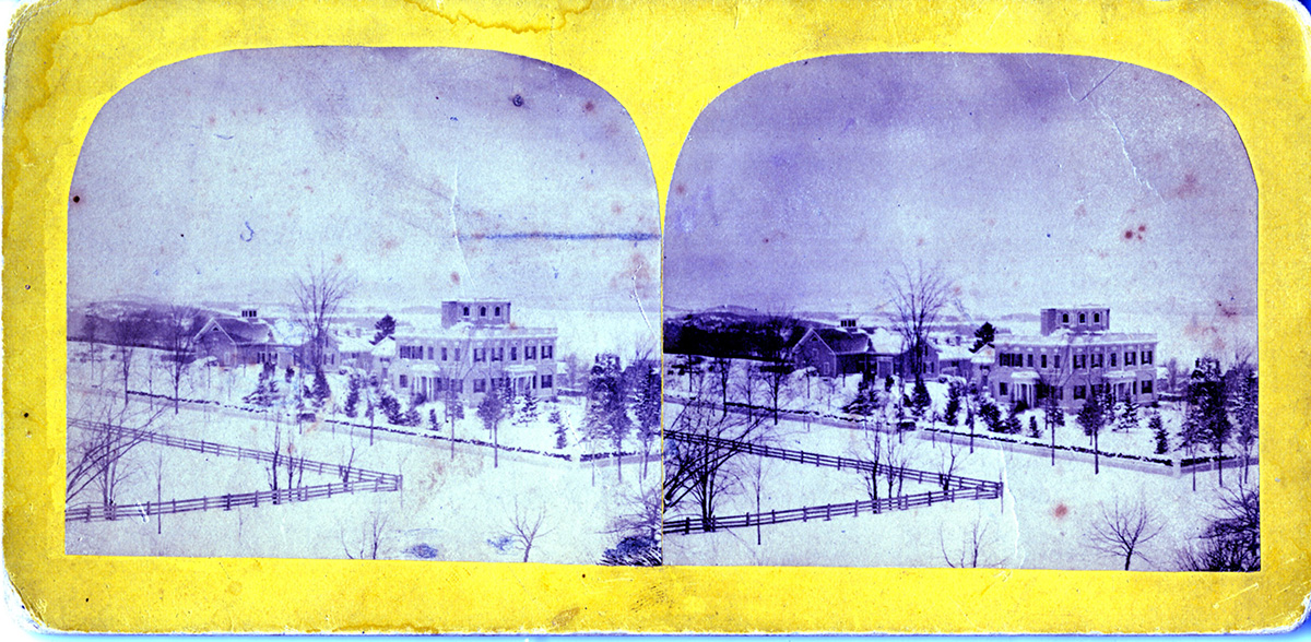
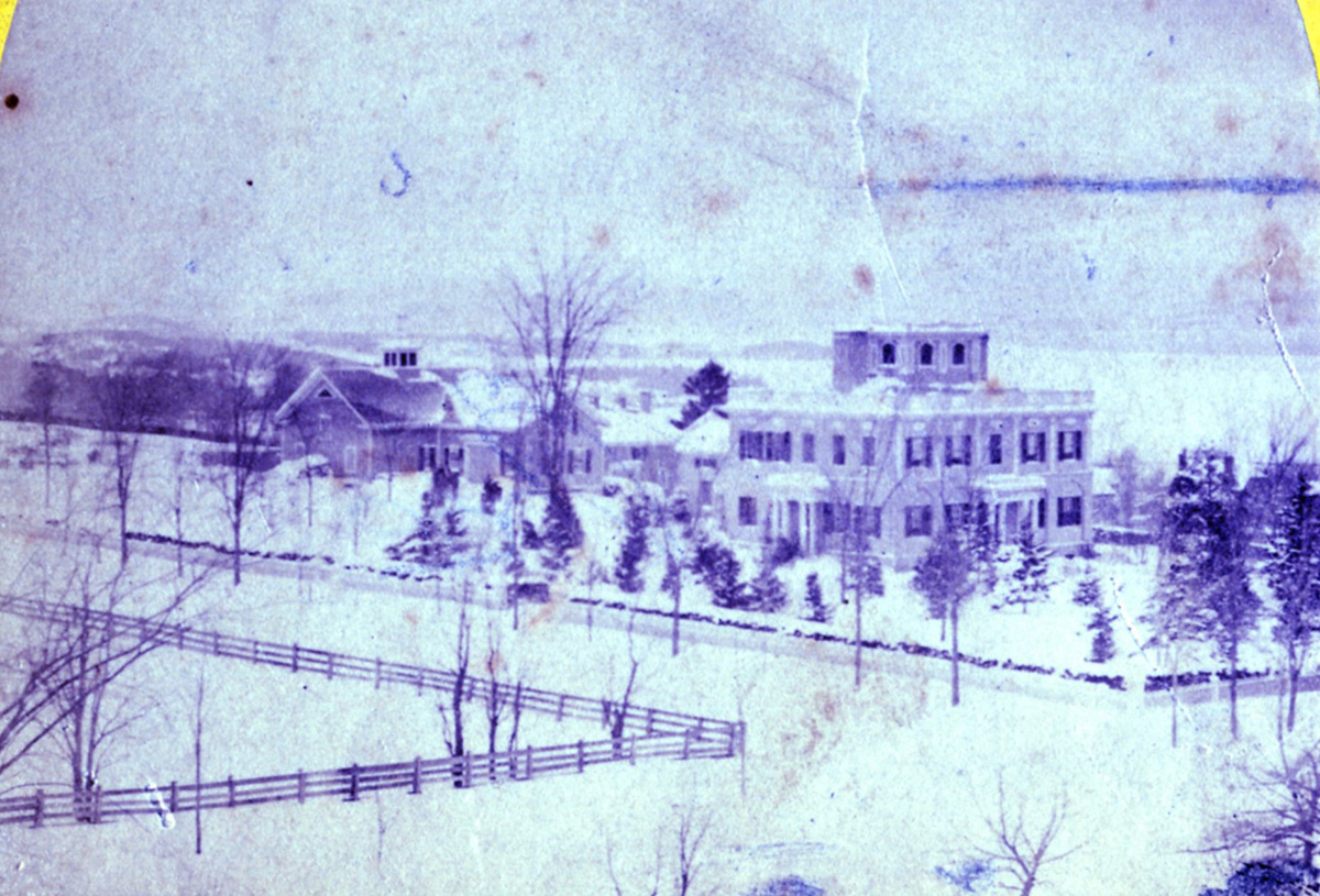
This stereograph is a broad view of the Hill section of Burlington looking southwest toward Lake Champlain. The image appears to be taken from an elevation. In the foreground is the recognizable Grasse Mount home. Very few structures are seen around Grasse Mount and there is an open treeless view of the corner of Main and Summit streets. The scene is wintery and pastoral, and could be a rural scene if not for the tidy fence lines and street formations.
Fig. 22. Stereograph Image 7. Courtesy of University of Vermont Special Collections.
Fig. 23. Cropped Image 7.
Today
The vantage point is the roof balistrade of the Wheeler House at 133 South Prospect Street.
Fig. 24. Hill Section from the top of Wheeler House (view looking southwest). Photo by Dr. Thomas Visser, 2012.
History
The Wheeler house was standing across Main Street from Grasse Mount since at least 1853 as verified in drawings on 1853 and 1869 Burlington maps.
The scene of the area around Summit and Main Streets in the stereograph coincides with the 1869 Beers map showing an absence of structures to the immediate left (east) or uphill from Grasse Mount. However, the large L-shaped structure shown in the image to the left (south) of Grasse Mount was not there in 1869. It appears to be a carriage house with a cupola and a large bay door on the right side, and also looks to belong to Grasse Mount. By 1877 that structure was shown there as were other structures within the lot to the right (west) of Grasse Mount, similar to the image.54 Other structures however are shown farther left (south) of the carriage house on the same block on the 1877 Bird’s Eye Map. Therefore, the date range for the stereograph is between 1870 and 1876.
Access to the top of the Wheeler House on the University of Vermont campus is restricted, however the photograph above taken by Dr. Thomas Visser in 2012 from that exact vantage point closely matches the view, with the top of Grasse Mount identifiable through an abundance of trees.
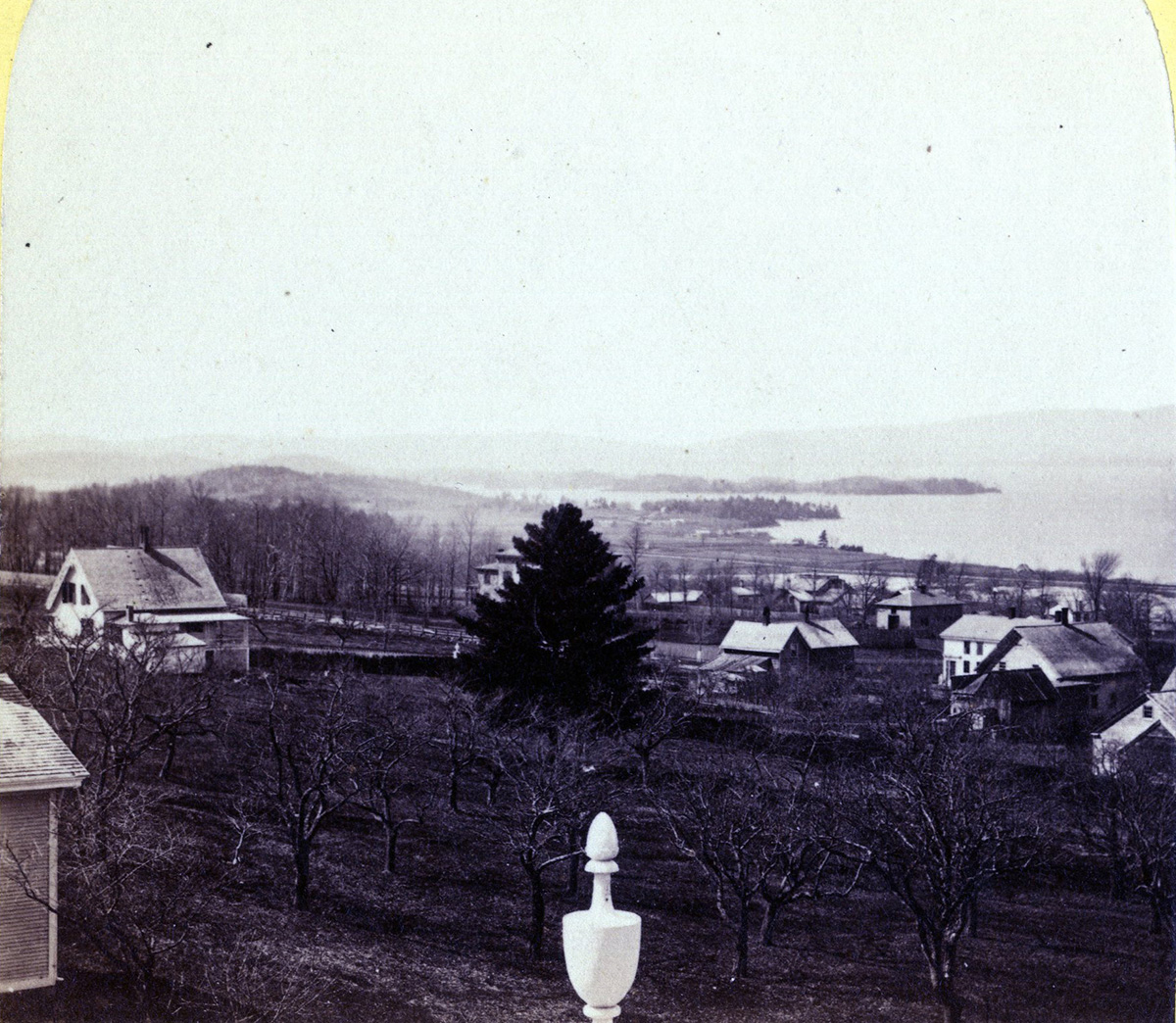
Image 8
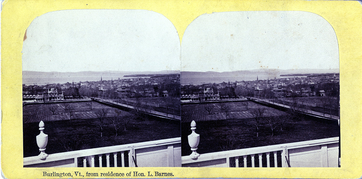
The view of this stereograph is from the belvedere of Grasse Mount (an enclosed lookout at the top of the home), looking west-northwest toward Lake Champlain along Main Street. Similar to Stereograph Image 7 very few structures are seen in the foreground. The entire block adjacent to Grasse Mount down the hill toward the lake is undeveloped.
Fig. 25. Stereograph Image 8. Courtesy of University of Vermont Special Collections.
Fig. 26. Cropped Image 8.
Today
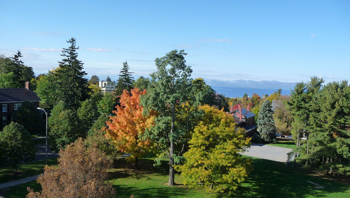
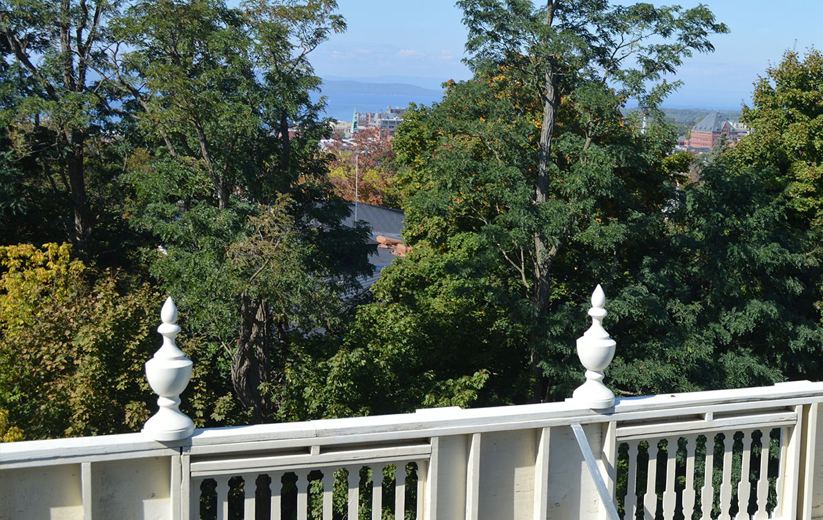
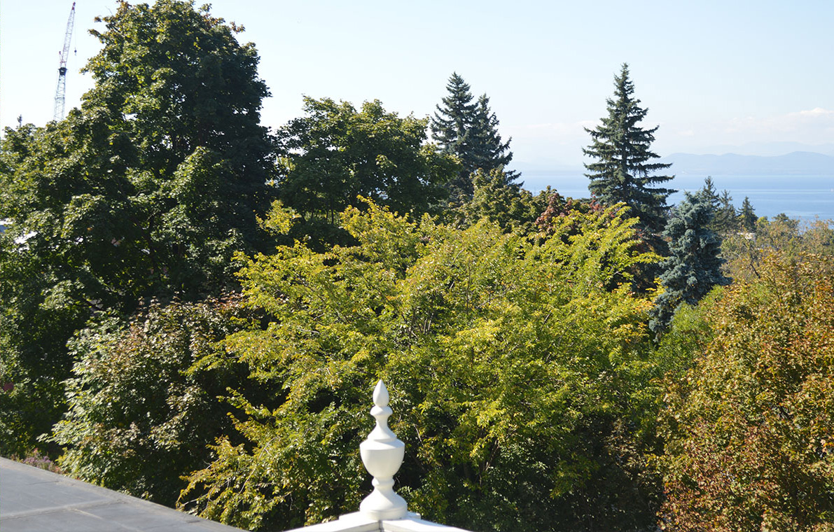
Standing in the belvedere of Grasse Mount today the view down Main Street and Lake Champlain is partially blocked by trees. The modern photo was taken in the same direction down Main Street toward Lake Champlain facing west-northwest. The ornamental finials shown on the belvedere’s balustrade today are similarly placed to those in the stereograph although today’s finials are replacements of the originals.
Fig. 27. Burlington and Lake Champlain from the Belvedere at Grasse Mount, 411 Main Street (view looking west-northwest). Photo by author, October 2014.
History
The foreground of the stereograph matches both the 1853 Presdee map and the Beers 1869 map, showing no structures built between Grasse Mount and the large home standing one block to the west (visible at left-center in the image). The 1877 Bird's Eye map drawing shows additional structures built in that area, so it was taken prior to that year. Since the stereograph view is listed as “Lake Champlain from residence of Hon. L. Barnes,” the date range includes the years Mr. Barnes lived at the home as determined in the history of Image 1 above, i.e., beginning in 1866. Therefore the sterograph was taken between 1866 and 1876.
Image 9
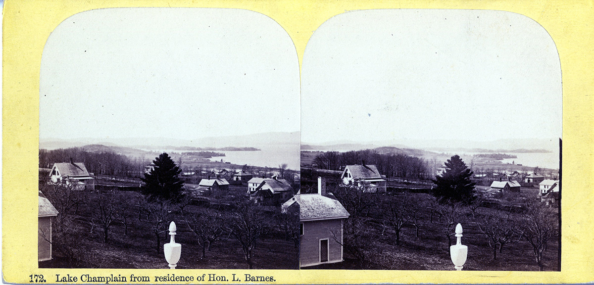
Taken from the belvedere atop Grasse Mount at 411 Main Street.
Fig. 28. Stereograph Image 9. Courtesy of University of Vermont Special Collections.
Fig. 29. Cropped Image 9.
Today
The new photograph shows mostly trees with Lake Champlain in the distance.
Fig. 30. Lake Champlain from the belvedere at Grasse Mount, 411 Main Street (view looking southwest). Photo by author, October 2014.
History
This stereograph is estimated but not confirmed to have been taken at the same time as Stereograph Image 8. In this view a few structures rest between Grasse Mount and the lake, looking west-southwest from the belvedere. The same finials and balustrade are apparent in the image, and both stereographs have a similar yellow border. The structures drawn on the 1869 Beers map could be the ones visible here but it is indeterminable. By 1890 the land on that side of Grasse Mount hadn’t changed much but for a few more structures.55 If this image was taken at the same time as Image 8 the latest year of the stereograph would be 1876. Due to a lack of verifiable structures on the maps, however, as well as the difference in text on the two stereographs (Image 9 is marked "172" whereas no number is indicated on Image 8), the date range is limited to when Mr. Barnes resided at Grasse Mount, between 1866 and 1886.
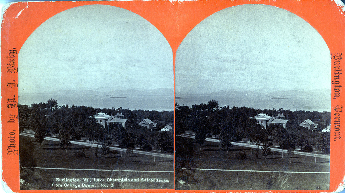
Image 10
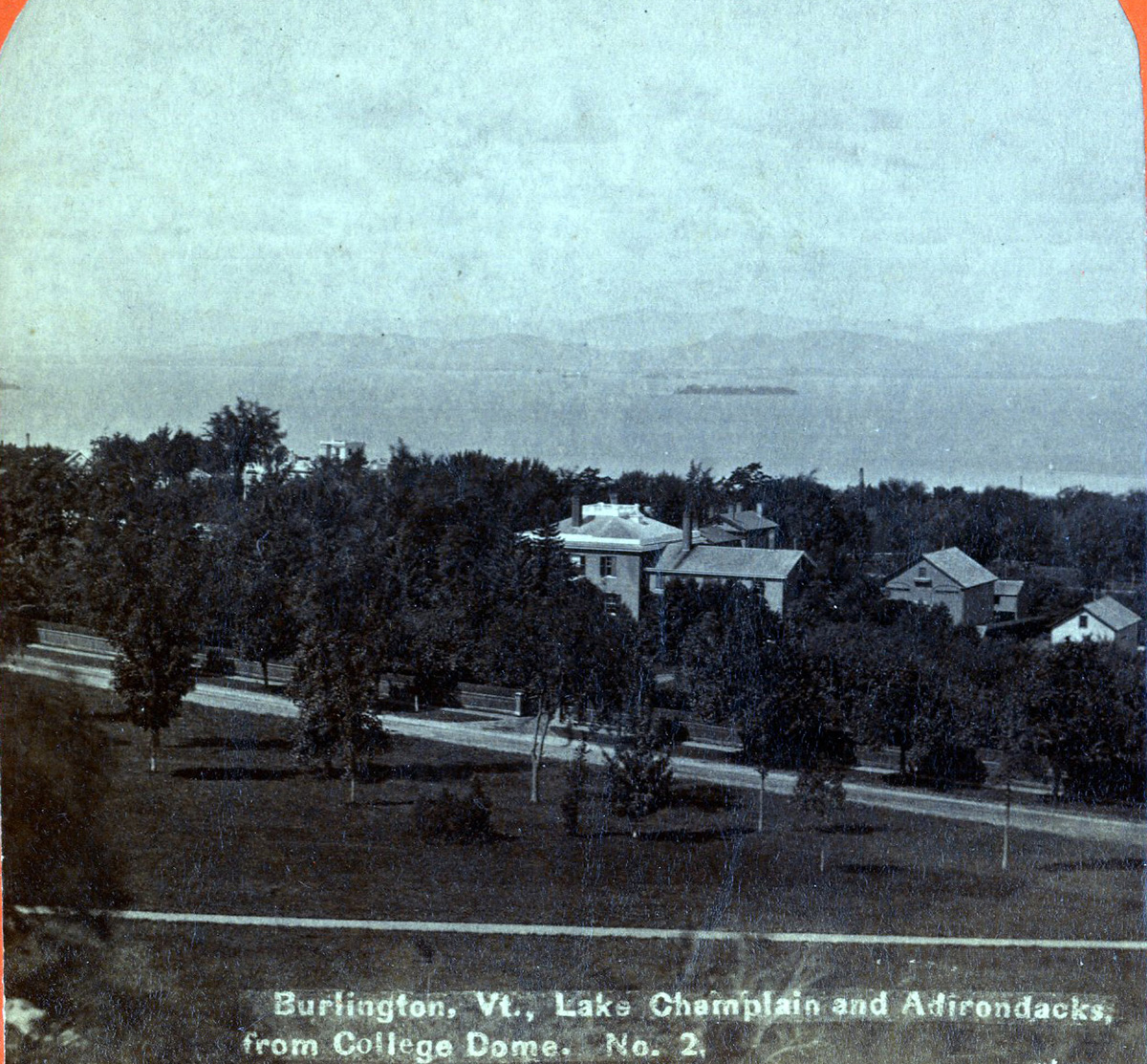
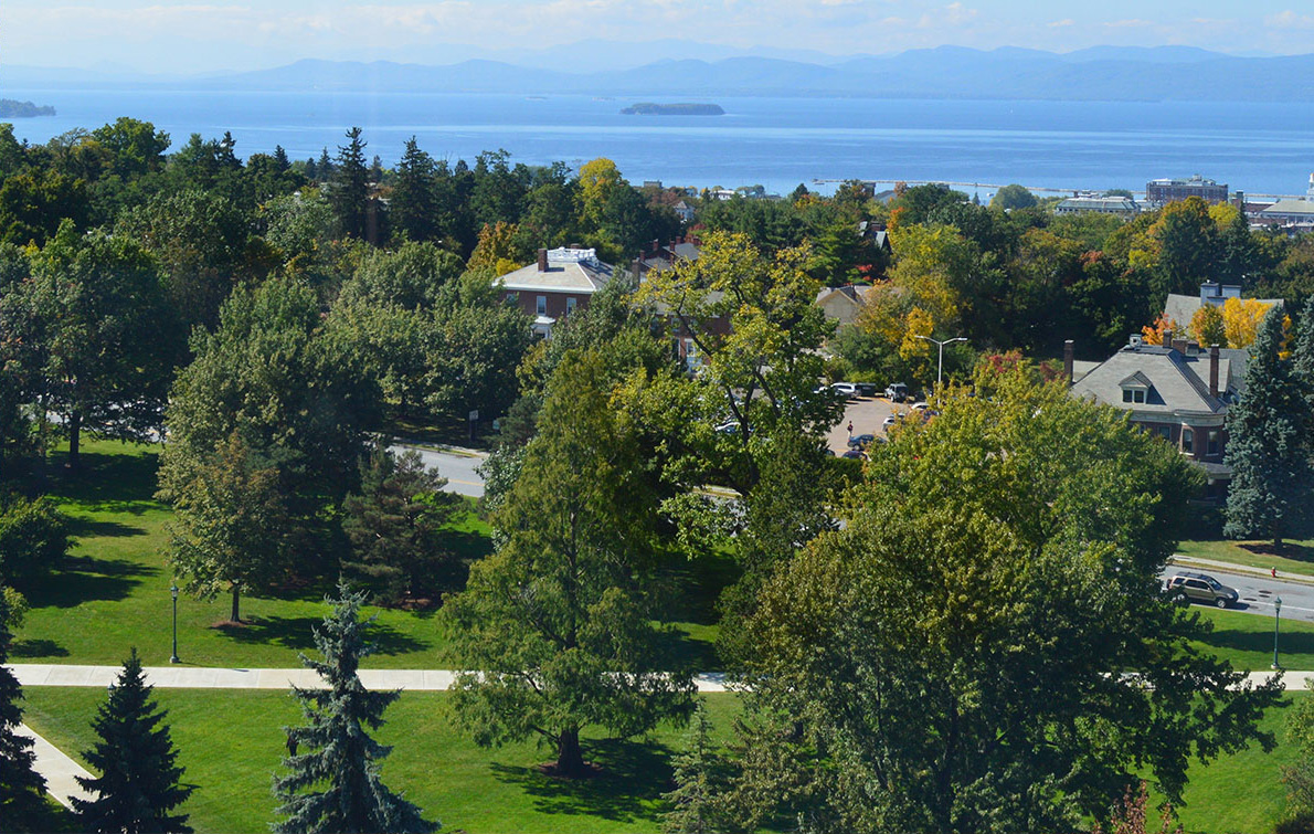
This is an interesting panoramic view of the hill section of Burlington and Lake Champlain taken from the University of Vermont College Dome that existed prior to the current Old Mill belfry that replaced it after reconstruction. The University Green is clearly visible in front of what is now South Prospect Street. UVM's Wheeler House (home of the Historic Preservation Department) is at the center and the top of Grasse Mount is also visible above the trees. Beyond Lake Champlain are the Adirondacks of New York. On the front of the stereograph is printed “Burlington, Vt., Lake Champlain and Adirondacks, from College Dome. No. 2.”
Fig. 31. Stereograph Image 10. Courtesy of University of Vermont Special Collections.
Fig. 32. Cropped Image 10.
Today
The view from the University of Vermont's Old Mill building belfry.
Fig. 33. Burlington, Lake Champlain, and the Adirondacks (view looking southwest from the Old Mill building belfry, University of Vermont). Photo by author, October 2014.
History
The structures in view match the 1862 Presdee Map of Burlington as well as the 1869 Beers map of Burlington. The very latest the stereograph image could have been taken would be when the College Dome was taken down in 1882: “Now that the main college edifice is in process of reconstruction, some account of the various buildings erected for the uses of the University may not be without interest to graduates and friends of the institution, and to the general public.”56
For fifty three years the College Dome was a prominent part of the urban landscape and of great importance to Burlington residents and alumni of the University. “The middle college was erected and nearly completed in 1829 and cost about $9,000. The dome by which it was surmounted and which for more than fifty years served as a beacon for the wide region of country between the Green Mountains and the Adirondacks…came naturally to be regarded by alumni and the permanent residents of Burlington with special interest…that whatever might be done with the rest of the “Old Brick Mill,” its shining dome, the great landmark of the valley, might be preserved in its integrity.”57
Indeed the dome itself was a part of the built landscape and beauty of Burlington as well as a way to observe a panoramic view of the surroundings. But perhaps the beauty of the area and the dome itself were not fully appreciated at the time: “We heard it very justly remarked, the other day, that Burlington people do not seem to appreciate as they ought the charms of natural scenery with which our beautiful city is environed.” “The fact is, we have heard so much about our city’s being “Beautiful for situation,” “sloping with foliage–embowered streets from the University building, which crowns the hill, to the beautiful bay which nestles at its foot,” and so forth, indefinitely, that it has got to be an old story with us, and we are very willing to take it all for granted.” “First…we will turn to the east, and follow College street to the top of the hill, gaze with regret upon the ruins of the old University building, from whose dome we were wont to look out upon a wide-reaching view unsurpassed in story or in art – and not very often in reality.”58
The modern photograph was taken from atop the University of Vermont's Old Mill building inside the belfry. The trees have grown in the foreground and the streets are now paved. Pathways on the University Green still follow the same lines. A fence that ran along the West side of South Prospect in front of Wheeler is gone. A parking lot is now standing to the north of Wheeler house where there had been only green open land with no structures. The Wheeler house carriage house is different today as well, though it stands in the same place and is visible in both old and new images.
A small white carriage house or outbuilding at the far right of the stereograph that belongs to the R.W. Francis estate is drawn at that location on the 1890 Hopkins map, but it is not showing on the 1877 Birds Eye Map. However the Birds Eye Map may have simply omitted the building. Therefore, since the college dome was taken down in 1882, the date range of the stereograph is between 1862 and 1882.
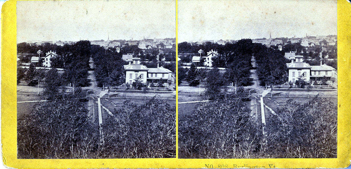
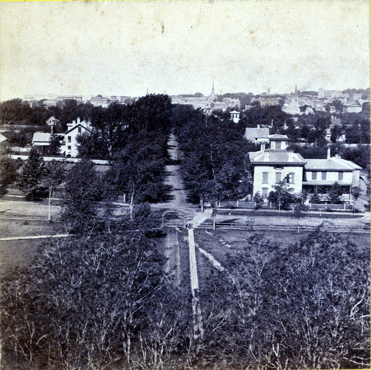
Image 11
This view is also from the College Dome looking east down College Street in Burlington with Lake Champlain in the distance. The streets were then unpaved with no curbs and no traffic signals or signs. A gate at the entryway to the University Green is present as well as a fence running north from the gate along the green. Notably no fountain exists in the middle of the green as it does today. An Italianate style house stands at the northwest corner of College and South Prospect Streets where the Waterman building of the UVM campus stands today.
Fig. 34. Stereograph Image 11. Courtesy of University of Vermont Special Collections.
Fig. 35. Cropped Image 11.
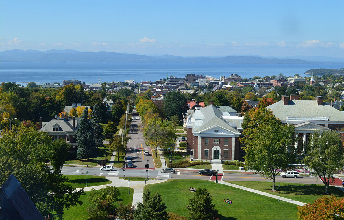
Today
The view from the University of Vermont's Old Mill building belfry.
Fig. 36. University Green, downtown Burlington, and Lake Champlain (view looking east). Photo by author, October 2014.
History
In 1869 the large Italianate style house in the stereograph that stands where the Waterman building is today was owned by an A.C. Spears.59 The first house visible on the left, on the south side of College Street, belonged to an R.W. Francis.60 Both of these structures match the names at those locations on the 1862 Presdee Map as well as names and drawings of those locations on the Beers 1869 Burlington map. The stereograph shows the University Green in the foreground without a fountain. On the 1877 Birds Eye map a circle is drawn in that area indicating the sidewalk had changed, and possibly the fountain had been installed at that location by that time. Whether or not the fountain itself had been built, the sidewalk change indicates the stereograph was taken prior to 1877. Therefore the date range of the stereograph is between 1862 and 1876.
Maps
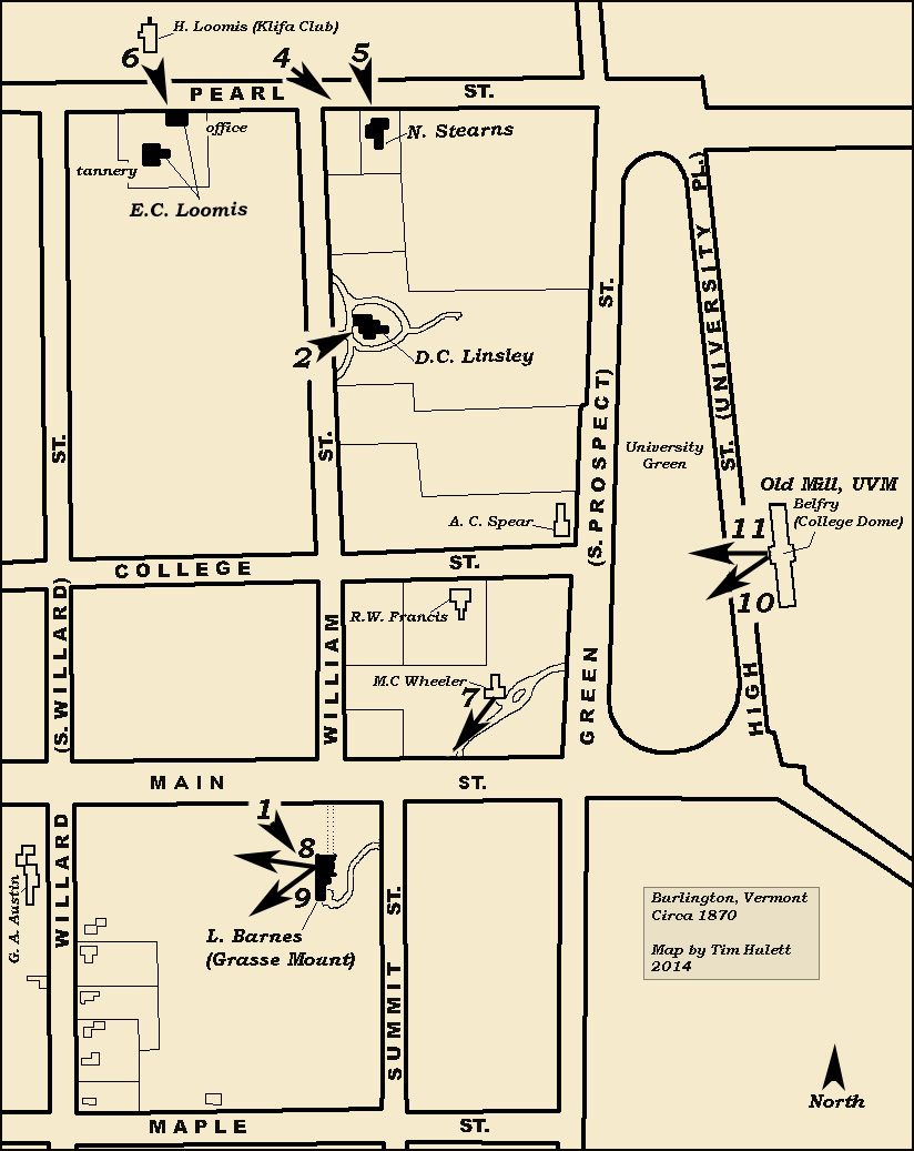
The map below shows the vantage points for all images except for Image 3. The arrow represents where the photographers stood and the direction of the camera.
Fig. 37. Burlington circa 1870. Map by author, November 2014.
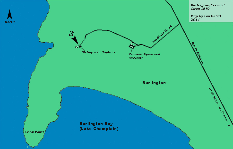
This map shows the vantage point of Image 3, the site of the Bishop's home and wedding anniversary in June of 1866.
Fig. 38. Burlington, Rock Point circa 1870. Map by author, November 2014.
Notes
1. The Pupils of the Second Year English Classes, Burlington Junior High School, 1920-1921, Burlington, Vermont: A Brief Sketch of its History, Educational Facilities, and Industrial Life (Burlington, VT: N.P., 1921), 20.
2. Ibid, 20.
3. Ibid, 21.
4. Burlington City Directory 1866-1867 (Burlington, VT: Hiram S. Hart, Free Press Steam Printing House, 1866), 20.2.
5. Burlington City Directory 1879-1880 (Burlington, VT: The Free Press Association, 1881), 5.
6. Burlington City Directory 1886-1887 (Burlington, VT: Free Press Association, 1886), 10.
7. Burlington City Directory 1866-1867 (Burlington, VT: Hiram S. Hart, Free Press Steam Printing House, 1866), 20.
8. Frederick W. Beers, Plan of the City of Burlington, Chittenden Co., Vt, 1869 (University of Vermont, Special Collections: 1869), map.
9. “Lawrence L. Barnes, A Sketch of His Life and Business Enterprises,” Burlington Weekly Free Press, June 25th, 1886, accessed November 2nd, 2014,
http://chroniclingamerica.loc.gov/
10. Burlington City Directory 1893 (Burlington, VT: L.P. Waite and Co., 1893), 78.
11. Frederick W. Beers, Plan of the City of Burlington, Chittenden Co., Vt, 1869 (University of Vermont, Special Collections: 1869), map.
12. E. Meilbeck, Bird’s Eye Map of Burlington, Vermont, 1877 (University of Vermont, Special Collections: 1877), map.
13.
Worley and Bracher, Plan of the City of Burlington, Chittenden Co., Vt, 1869 (University of Vermont, Special Collections: 1869), map.
14. Ibid.
15. Burlington City Directory 1865-1866 (Burlington, VT: Hiram S. Hart, Free Press Steam Printing Establishment, 1865), 54.
16. Burlington City Directory 1881-1883 (Burlington, VT: The Free Press Association, 1881), 61.
17. Ibid, 61.
18. C. Wainwright, The Village of Burlington, Vt., 1862 (University of Vermont Special Collections, 1862), map.
19. Committee to Save the Bishop’s House et al v. Medical Center Hospital of Vermont, Inc., 388 A.2d 827 (VT 1978), LexisNexis.
20. David J. Blow, Historic Guide To Burlington Neighborhoods, Vol. 1 (Burlington, VT: Chittenden County Historical Society, 1991), 66.
21. “The Golden Wedding,” Burlington Weekly Free Press, June 22nd, 1866, accessed October 15th, 2014,
http://chroniclingamerica.loc.gov
22. Ibid.
23. Ibid.
24. Ibid.
25. Ibid.
26. The Pupils of the Second Year English Classes, Burlington Junior High School, 1920-1921, Burlington, Vermont: A Brief Sketch of its History, Educational Facilities, and Industrial Life (Burlington, VT: N.P., 1921), 2. 26. David J. Blow, Historic Guide to Burlington Neighborhoods, Vol. 1 (Burlington, VT: Chittenden County Historical Society, 1991), 66.
27.
David J. Blow, Historic Guide to Burlington Neighborhoods, Vol. 1 (Burlington, VT: Chittenden County Historical Society, 1991), 16.
28. Ibid, 66.
29.
Ibid.
30.
Joseph Auld, Picturesque Burlington (Burlington, VT: Burlington Free Press Association, 1894), 105.
31.
Ibid.
32.
The Pupils of the Second Year English Classes, Burlington Junior High School, 1920-1921, Burlington, Vermont: A Brief Sketch of its History, Educational Facilities, and Industrial Life (Burlington, VT: N.P., 1921), 21.
33. Burlington City Directory 1867-1868 (Burlington, VT: Hiram S. Hart, Free Press Association, 1867), 47.
34.
David J. Blow, Historic Guide To Burlington Neighborhoods, Vol. 1 (Burlington, VT: Chittenden County Historical Society, 1991), 16.
35.
Ibid, 17.
36.
“Death of Bishop Hopkins,” Burlington Weekly Free Press, January 17th, 1868, accessed October 15th, 2014, http://chroniclingamerica.loc.gov
37. Burlington City Directory 1865-1866 (Burlington, VT: Hiram S. Hart, Free Press Steam Printing Establishment, 1865), 78.
38. C. Wainwright, The Village of Burlington, Vt., 1862 (University of Vermont Special Collections, 1862), map.
39. Burlington Bicentennial Committee, Bygone Burlington (Burlington, VT: N.P., 1976), 45.
40. Burlington City Directory 1877-1878 (Burlington, VT: Free Press Association, 1877), 134.
41. David J. Blow, Historic Guide to Burlington Neighborhoods, Vol. 1 (Burlington, VT: Chittenden County Historical Society, 1991), 109.
42. Ibid, 109.
43. “Klifa Club, Burlington,” The University of Vermont Libraries, Center for Digital Initiatives, accessed October 15th, 2014, http://cdi.uvm.edu/collections
44. Charles E. Allen, About Burlington, Vermont (Hobart J. Shanley & Company: Burlington, Vermont, 1905), 97.
45. Frederick W. Beers, Plan of the City of Burlington, Chittenden Co., Vt, 1869 (University of Vermont, Special Collections: 1869), map.
46. “Mechanical Manufactures,” Burlington Weekly Free Press, September 28th, 1866, accessed November 8th, 2014,
http://chroniclingamerica.loc.gov
47. “The Oldest,” Burlington Weekly Free Press, May 8th, 1868, accessed November 8th, 2014,
http://chroniclingamerica.loc.gov
48. Burlington City Directory 1869-1870 (Burlington, VT: The Free Press Association, 1869), 54.
49. Burlington City Directory 1866-1867 (Burlington, VT: Hiram S. Hart, Free Press Steam Printing House, 1866), 49.
50. Ibid, 18.
51. Burlington City Directory 1881-1883 (Burlington, VT: The Free Press Association, 1881), 2.
52. G.M. Hopkins, Map of the City of Burlington, Vermont 1890 (University of Vermont Special Collections, 1890), map.
53. Ibid.
54. E. Meilbeck, Bird’s Eye Map of Burlington, Vermont, 1877 (University of Vermont, Special Collections: 1877), map.
55. G.M. Hopkins, Map of the City of Burlington, Vermont 1890 (University of Vermont Special Collections, 1890), map.
56.
“The University Buildings of the Past. Sketch of the Old Structures,” Burlington Weekly Free Press, August 18th, 1882, accessed November 9th, 2014,
http://chroniclingamerica.loc.gov
57. Ibid.
58. “Pleasant Places About Burlington,” Burlington Weekly Free Press, July 7th, 1882, accessed November 9th, 2014, http://chroniclingamerica.loc.gov
59. Burlington City Directory 1869-1870 (Burlington, VT: The Free Press Association, 1869), 78.
60. Ibid, 39.