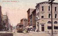
Church St. looking north from College St.
Postmarked: August 5, 1910
Church St. looking north from College St.
Postmarked: 1916
Church Street
From College Street to Bank Street
One block south of the Union-Central Building Block two other significant historic buildings come into view on the westerly side of Church Street. The postcard titled, 'Church St. looking north from College St.', mailed on August 1910, presents a street view dominated by the Sherman Building and the Howard Opera House. The three-story Sherman Building, circa 1847, is located at the front of the block on the northwesterly corner of Church Street and College Street. To the north are a four two- to four-story structures, used at the time for small business operations, and all constructed prior to 1880. (1) A billboard for "Celery Compound" calls attention to the four-story Howard Opera House, circa 1878. In the background, one can faintly make out the roof of the Masonic Temple and the Unitarian Church at the head of the street. Three- and four-story brick buildings occupied the east side of the block between Bank Street and College Street. At the time of this postcard the northerly most building on the block contained a store; heading south, the next few buildings contained dwellings, a hardware store, a lighting supply store, a telegram office, a clothier, and a grocer. Finally, the building in the immediate foreground was the Howard Bank, constructed in 1902. (2)
Compared with the 1916 postcard 'Church St. looking north from Bank St.,' this image displays a busier streetscape. The storefront awnings are down over the wide sidewalks, which are scattered with pedestrians and utility poles. These clues suggest the image was taken in the late morning or early afternoon; since the east facing buildings are shaded and the west facing stores are in full light it is safe to conclude the postcard image was indeed captured in the afternoon. Where a car appears in the postcard sent in 1916, here, six years earlier, a horse and buggy ride down the paved street. This further illustrates the many changes Church Street has undergone throughout its history.
Postcards from the early twentieth century show a fully developed streetscape with building facades lining the easterly and westerly sides of Church Street, but this was not always the case. An 1830 map of Burlington reveals a far less developed neighborhood. (3) The highest concentration of buildings was between College Street and Bank Street, followed by a sparse scattering of structures from Bank Street continuing north to Pearl Street. (4) The Unitarian Church is the only building massing found on this map as it appears in the postcard photographs. The rapidly changing Burlington landscape of the mid-to-late-nineteenth century elicited observation in an 1844 article from the Burlington Union, "Buildings to the north of us, buildings to the east of us, buildings to the south of us, buildings to the west of us. It is worth while to take a stroll about town and see the new buildings going up." (5) This period of development in Burlington significantly contributed to the numerous and diverse structures of today's downtown.
In the current photograph (below), taken on the corner of Church Street and College Street, looking north, the Howard Opera House and subsequent northerly blocks are obstructed from view by the addition of trees. Modern glass-plated awnings, a banner for the city's Halloween parade, and a stop sign on the lamppost indicate some of the recent changes Church Street has experienced. The delivery truck on the pedestrian way is telling of both the early time at which the photograph was taken, and points to a more modern association. Finally, the contemporary touch of a neon-lit sign, that says "camera," peaks through a tree between the Leunig's Building and the Howard Opera House Building.
Church St. looking north from College St.
October 19, 2012, 8 a.m.
1. Church Street Historic District, National Register of Historic Places Nomination, National Park Service, 2009, 80-86; accessed at www.burlingtonvt.gov/PZ/Historic-Preservation/National-Register-of-Historic-Places/
2. Sanborn Fire Insurance Maps, Burlington, VT, 1906.
3. Ammi B. Young, Map of Burlington Village, 1830.
4. Ibid.
5. "Locals," Burlington Union, vol. 1 no. 7 (May 9, 1884): 2.