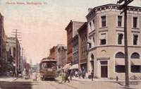
City Hall Park near College Street circa 1904, looking south-southeast. Postcard courtesy of Special Collections, UVM Bailey-Howe Library.
City Hall Park at College Street, November 14, 2012 looking SSE. Photo by Suzanne Mantegna.
In addition to the Fletcher Free Library cupola, and original City Hall, this image gives a glimpse of Main Street from street numbers 139 to 163. In the center of the park is the fountain that was donated by John Purple Howard in 1881.(1) The Sanborn Insurance maps for the City of Burlington for 1894 show the layout of the park to be rectangular with a fountain in the center with two diagonal walking paths from corner to corner and a path that runs north-south and one that runs east-west. The map also shows a reservoir. In the postcard there appears to be a cast iron column capped by an urn in the location of the reservoir. There are benches lining one side of each walkway. According to an advertising pamphlet for the Van Ness House, in summer the Sherman Military Band would play music in the evenings in the park.(2)
At the Burlington Proprietor's Meeting held on June 26, 1798, a two and a half acre lot was set aside for a common and governmental buildings. However, several buildings including the original log County Courthouse were built on the common. In 1830, the owner of a house on Main Street, John Norton Pomeroy, was upset at all the buildings that were being built on what should have been common land and filed suit against the city. Pomeroy won and all the buildings that were in City Hall Park were removed, leaving a one and three-quarter acre lot for the park and the remaining acreage on Church Street for governmental buildings.(3) The Sanborn Insurance map for the City of Burlington for 1869 shows the shape of the common was an oval. It remained an oval until after the Civil War. In 1874, the City Council passed a resolution to put in curbs to stop the using of the park as a shortcut and in 1875 money was spent to install stone curbs.(4) However, the owner of the building at the corner of College and Church Street abutting City Hall Park was unhappy with the proposed installation of curbs and brought suit against the city. He lost and the curbs were installed and the shape of the common became rectangular.(5)
The buildings from 163 to 139 Main Street have been there since the mid 1800's. The small two-story brick building on the left at 161-3 Main Street was built prior to 1850 and had a gable roof with a fan louver.(6) The building to the right at 155-159 Main Street was listed on the Sanborn Insurance map for the City of Burlington for 1869 as a three-story brick building with a slate roof and frame cornice. The next building to the right (149-153 Main Street) is the location of the City Hotel and was a four-story brick building with a slate roof.(7) The final building visible is from 139-145 Main Street and is all that remains of The American Hotel that was built on this site. Former Gov. Cornelius Van Ness founded The American Hotel in 1824 and built the three-story brick wing in 1844. The American Hotel burned December 16, 1906 and one woman died in the fire. Burlington Wine and Liquor Store was on the main level of The American Hotel and the heat from the flames caused the liquor to explode and the northern wall (Main Street) to collapse.(8)
The City Hall building dating from 1928 replaces the previous City Hall and the old Fletcher Free Library. The fountain donated in 1881 was removed and a new 60 foot poured concrete reflecting pool was dedicated on July 4, 1976. In 1994, the fountain that formerly was at the foot of College Street and built in 1905 was installed as the centerpiece of the fountain.(9) Since 1875, City Hall Park has retained the same rectangular shape, however the north-south path has been removed. There are still benches but not as many as in the postcard.
Several of the buildings from the postcard remain on Main Street today. The two-story building at 161-163 Main Street still stands although it has been significantly altered and is the home to Ahli Baba's Kabob Shop. Next-door at 155-159 Main Street is the three-story brick building with the frame cornice that Ruben James and the Kountry Kart Deli call home. The biggest change on Main Street is the building that comes next, the Flynn Theatre at 149-153 Main Street. The Flynn opened for the first time on November 26, 1930 and was the first theatre that was built for "talkies" in Burlington. The Boston architecture firm of Newell and Rand designed the Art Deco building.(10) It operated primarily as a movie house until 1972 when Merrill Jarvis acquired The Flynn and realized that it would also be a great venue for live performances. He replaced the fixed screen with a moveable one and in 1974 the Lyric Theatre Company started performing live musicals there.(11) In 1981, the Flynn Center for the Performing Arts, spearheaded by the Lyric Theatre, purchased and renovated the building.(12) The building continues to be the main venue in Burlington for live performances. The building at 139-143 Main Street is the east wing of what was the American Hotel. Today it is the site of various stores including The Bern Gallery and JR's Pub with apartments above.
Notes:
1. City of Burlington, Seventeenth Annual Report for the City of Burlington, Vermont for the year ending December 31, 1881 (Burlington, VT: Free Press Printing, 1882) 43.
2. The Van Ness, (Burlington, VT: Hays Advertising Agency Pamphlet, circa 1912).
3. David J. Blow, Historic Guide to Burlington Neighborhoods, vol. 2 (Burlington, VT: Chittenden County Historical Society, 1997), 43-7.
4. City of Burlington, Eleventh Annual Report of the City Government for the City of Burlington, Vermont for the year ending December 31, 1881 (Burlington, VT: Free Press Book and Job Printing House, 1882) 82.
5. David J. Blow, Historic Guide to Burlington Neighborhoods, vol. 2 (Burlington, VT: Chittenden County Historical Society, 1997), 43-7.
6. National Park Service, National Register for Historic Places Nomination Form: Court House Square, prepared by John C. Page, 1982, p. 6.
7. Sanborn Insurance Map for the City of Burlington (Sanborn Insurance Company, 1894), sheets 16-18.
8. "Woman Perished in Ruins," Burlington Free Press (Burlington, VT), December 20, 1906.
9. City of Burlington, One hundred and Eleventh Annual Report of the City of Burlington, Vermont for the year ending June 30, 1976 (Burlington, VT: Free Press Association, 1976) 22-52.
10. David J. Blow, Historic Guide to Burlington Neighborhoods, vol. 2 (Burlington, VT: Chittenden County Historical Society), 48.
11. National Park Service, National Register for Historic Places Nomination Form: Court House Square, prepared by John C. Page, 1982, p. 7.
12. History of the Flynn, Accessed October 28, 2012, http://www.flynncenter.org/about-us/history.html.